Catalogue des publications
- Pour effectuer une commande, remplissez votre panier puis terminez votre commande. Vous pourrez effectuer un paiement sécurisé et être livré dans le monde entier. J’ai un code promotionnel
- To perform an order, fill your cart then proceed the order. You will be driven to a secured page for the electronic payment which includes worldwide shipping fees. I have a promotional code.
Fouilles de l’Institut français d’archéologie orientale (FIFAO)
La collection Fouilles de l’Institut français d’archéologie orientale (FIFAO) se consacre à la publication scientifique des travaux archéologiques conduits sur l’ensemble des chantiers de l’Ifao. Elle est constituée de plusieurs séries : Balat, Tebtynis, Karnak-nord, Archéologie islamique, etc.
ISBN 9782724705669
2012 IFAO
Collection: FIFAO 62
Langue(s): français
1 vol. 249 p.
89 € (4450 EGP)
Frédéric Colin (éd.)
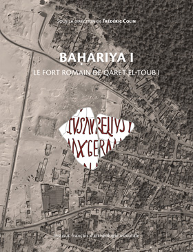
Baḥariya I. Le fort romain de Qaret el-Toub I
Qaret el-Toub est un des rares sites du nord de l’oasis de Bahariya à avoir échappé aux prospections archéologiques menées par Ahmed Fakhry dans les années 1930-1940. Le substrat rocheux y accueille un cimetière utilisé de la fin de l’Ancien Empire au Haut-Empire romain, qui fait partie de la vaste couronne de nécropoles entourant l’agglomération de Psôbthis, chef-lieu antique de la « Petite Oasis ». Dans le dernier quart du IIIᵉ siècle, des castra furent installés par-dessus les tombes, à l’aboutissement des pistes caravanières en provenance du sud (Darb el-‘Arbayin) et du nord-ouest (oasis de Siwa). Ce premier volume de la publication des fouilles de Qaret el-Toub s’attache à identifier la nature du site, à diagnostiquer le potentiel scientifique de son gisement archéologique et à établir le cadre chronologique dans lequel fut construite, entretenue et remployée la fortification d’oasis chargée de manifester localement et de protéger les institutions publiques de l’État romain. Comme le fort fut occupé sans discontinuer depuis sa fondation, sous Dioclétien et Maximien, jusqu’au Xᵉ siècle de notre ère, la séquence des habitats qu’il abrite constitue un observatoire privilégié pour l’étude de la période de transition entre l’Antiquité tardive et l’époque arabe.
Qaret el-Toub is one of the few sites in the northern Bahariya oasis that escaped the archaeological surveys conducted by Ahmed Fakhry in the 1930s and 1940s. A graveyard settled on the bedrock was used from the end of the Old Kingdom until the early Roman Period. It belongs to the large ring of cemeteries surrounding the urban area of Psôbthis, ancient chief town of the “Small Oasis”. In the last quarter of the 3rd century AD, military castra were installed over the graves in the incoming area of the caravan routes from the south (Darb el-‘Arbayin) and from the northwest (Siwa Oasis). This first volume of the final archaeological reports of the excavations at Qaret el-Toub attempts to identify the nature of the site, to make an assessment of the scientific potential of its archaeological field, and to determine the overall chronology of the history of this oasis fortress, that was built in order to embody locally and to protect the public institutions of the Roman State. As the fort was occupied continuously, from its building under Diocletian and Maximian until the 10th century AD, the sequence of occupation levels which it provides makes it an ideal research field for the study of the transitional period leading from late Antiquity to Arabic times.
- Frédéric Colin (
 : 117476145)
Professeur d’égyptologie, UMR 7044, université de Strasbourg
ISBN 9782724705881
2012 IFAO
Collection: FIFAO Fouilles franco-italiennes 68
Langue(s): français
1 vol. 410 p.
69 € (3450 EGP)
Pascale Ballet, Anna Południkiewicz
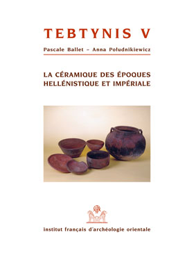
Tebtynis V. La céramique des époques hellénistique et impériale
Le cinquième volume des fouilles de Tebtynis, conduites par l’Institut de papyrologie de l’université de Milan et l’Institut français d’archéologie orientale, ouvre la série des études consacrées au mobilier de l’un des sites égyptiens les plus riches en matériel archéologique, du tournant de la conquête d’Alexandre le Grand jusqu’à la fin du IIᵉ s. apr. J.-C. Au moyen d’une analyse typo-chronologique de la céramique et complétée par la présentation de quelques contextes clos, l’étude met en lumière la production des céramiques et des amphores dans l’oasis du Fayoum ainsi que les importations en provenance d’autres régions d’Égypte et de Méditerranée. On dispose enfin du premier catalogue systématique portant sur la céramique à l’échelle du Fayoum et de la province égyptienne.
Dans cet ouvrage, sont soulignés, outre les grandes étapes de l’évolution du mobilier céramique, les rapports entre les mondes égyptien, grec et romain sur près de cinq siècles de consommation et, par voie de conséquence, les questions d’acculturation propres à l’Égypte hellénistique et impériale.
>>Lire l'avant propos.pdf- (0.3 Mb)
This fifth volume dedicated to the excavations jointly conducted at Tebtynis by the Institute of Papyrology of the University of Milan and the French Institute of Oriental Archaeology, introduces a series of studies devoted to the archaeological mate-rial from one of the richest Egyptian sites dating from the conquest of Alexander the Great to the end of the 2nd century AD, as regards archaeological artifacts. Through a typo-chronological analysis of the pottery, supplemented by the presenta-tion of a number of closed assemblages, the study puts the focus on the production of ceramics and amphorae in the Fayum Oasis as well as the imports from other areas of Egypt and the Mediterranean world. It is the first systematic catalogue on the ceramics of the Fayum Oasis and the province of Egypt.
Besides, highlighting the major stages in the evolution of ceramic artifacts, the book stresses the importance of the relationships within the Egyptian, Greek and Roman worlds over nearly five centuries and subsequently discusses the process of ac-culturation specific to Hellenistic and Roman Imperial Egypt.- Pascale Ballet ( : 030162734)
Pascale Ballet est professeure d’histoire de l’art et archéologie du monde romain à l’université Paris Nanterre. Membre du laboratoire ArScAn, UMR 7041 (équipe ESPRI-LIMC), elle dirige la mission archéologique de Bouto en Égypte en collaboration avec l’Institut archéologique allemand (Le Caire) et l’Institut français d’archéologie orientale (Le Caire). Elle codirige un programme de l’Ifao sur les contextes et les mobiliers. Ses recherches portent sur le commerce et la culture matérielle de l’Égypte gréco-romaine et byzantine et des régions voisines. - Anna Południkiewicz ( : 159068738)
ISBN 9782724705829
2011 IFAO
Collection: FIFAO 64
Langue(s): français
1 vol. 434 p.
45 € (2250 EGP)
Hélène Cuvigny (éd.)
Didymoi. Une garnison romaine dans le désert Oriental d’Égypte - 1. Les fouilles et le matériel.
Praesidia du désert de Bérénice IV
Didymoi – la Didyme de l’Itinéraire Antonin – fait partie de la douzaine de fortins (praesidia) construits par les Romains pour contrôler la route caravanière de Koptos, sur le Nil, à Bérénice, sur la mer Rouge. Son nom se réfère à ses divinités tutélaires, les Dioscures, invoqués par ses occupants dans leurs lettres privées, même si le matériel issu de la chapelle montre que le dieu principal était, comme dans toute la région depuis Trajan, Zeus Hèlios Grand Sarapis. Trois saisons de fouilles, menées entre 1997 et 2000 et financées par le ministère des Affaires étrangères et l’Ifao, ont mis en évidence les temps forts de l’histoire de Didymoi : fondation en 76/77 à l’instigation du préfet Iulius Ursus, renforcement des capacités de stockage d’eau sous Domitien, abandon probable dans le troisième quart du IIᵉ siècle, effondrement du puits, reconstruit en 176/177, l’année qui suit le séjour de Marc-Aurèle à Alexandrie. Mais bientôt l’occupation du fortin change d’allure : à la place des anciens casernements, régulièrement nettoyés, prolifèrent des locaux minuscules où les ordures s’amoncellent. C’est l’époque où les nomades (barbaroi), qui collaborent désormais avec l’armée romaine, viennent se ravitailler en pain et en vin dans les praesidia. Didymoi est définitivement abandonné vers le milieu du IIIᵉ siècle.
Dans ce premier volume sont présentés les résultats des fouilles et le matériel anépigraphe (à l’exception de la vaisselle céramique et des amphores). Didymoi s’est révélé un site exceptionnel pour les cuirs et pour les textiles. Les milliers de chiffons sortis des dépotoirs témoignent de la virtuosité des tisserands et des teinturiers égyptiens et de l’élégance vestimentaire des élites métropolitaines de la vallée du Nil ; ils révèlent en outre l’étonnante variété des produits textiles, de provenances très diverses, disponibles alors en Égypte.
Les inscriptions lapidaires et les ostraca grecs et latins sont publiés dans le second volume.
Didymoi – the Didyme of the Itinerarium Antoninianum – is one of the dozen fortlets (praesidia) that the Romans built to guard the caravan road from Coptos on the Nile to Berenice on the Red Sea. The name derives from its tutelary deities, the Dioscuri, who were invoked by the inhabitants in their private letters, although the finds from the chapel show that the pricipal god of the place, as in the whole region since the reign of Trajan, was Zeus Helios Great Sarapis. Three excavation campaigns between 1997 and 2000, campaigns that were financed by the French Ministry of Foreign Affairs and the Ifao, have brought to light the evidence for the important points of the history of Didymoi: the foundation in A.D. 76/77 ordered by the prefect Iulius Ursus, the enlargement of the facilities for storing water under Domitian, the probable abandon in the third quarter of the second century, the foundering of the well and its reconstruction in A.D. 176/77, the year that followed Marcus Aurelius’ visit to Alexandria. But soon after this the pattern of occupation changes: instead of the old barrack-rooms which were regularly cleaned, there are now a multitude of small rooms where rubbish abounds. This is the period when the nomads (barbaroi), who henceforth collaborate with the Roman army, come to the praesidia to obtain bread and wine. Didymoi is definitively abandoned towards the middle of the third century.
This first volume contains the results of the excavations and the uninscribed finds with the exception of ceramic tableware and amphorae. Didymoi is a remarkable site for leather and textiles. The thousands of rags that have been brought to light from the rubbish dump show the virtuosity of the Egyptian weavers and dyers and the sartorial elegance of the upper classes in the towns of the Nile valley. Furthermore, they show the extraordinary variety of the textile products, often imported from far away, that were then available in Egypt.
The inscriptions and the ostraca in Greek and Latin are published in the second volume.- Hélène Cuvigny ( : 028856988)
Papyrologue, directrice de recherche au CNRS (IRHT), directrice de l’Institut de papyrologie de la Sorbonne.
ISBN 9782724705850
2011 IFAO
Collection: FIFAO 66
Langue(s): français
1 vol. DVD+224 p.
45 € (2250 EGP)
Mahmoud Abd el-Raziq, Georges Castel, Pierre Tallet, Philippe Fluzin
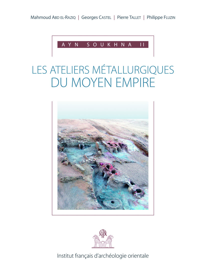
Ayn Soukhna 2.
Les ateliers métallurgiques du Moyen Empire
L'une des découvertes les plus importantes effectuées ces dernières années sur le site d'Ayn Soukhna, côte ouest du golfe de Suez, a été celle d'un important complexe d'ateliers métallurgiques bien datés du Moyen Empire égyptien, trouvés la plupart du temps dans un état exceptionnel. Ces ateliers présentent plusieurs petits espaces, délimités par des murs de pierre sèches, dans lesquels il est possible de suivre les différentes étapes du traitement du minerai de cuivre, de sa réduction – qui s'effectue dans des batteries de fours à ventilation naturelle – à la refusion du métal en creuset – phase finale du processus – dans des foyers en fer à cheval qui sont attisés par des cannes à souffler. La première partie de la présente étude, « Rapport archéologique », s'attache à faire la description précise de tous les éléments livrés par la fouille. La seconde partie, « Études archéométallurtiques », est la présentation d'un travail effectué sur une plate-forme expérimentale aménagée sur le site par les soins de l'UMR 5060 « Métallurgie et culture » . La combinaison de ces deux approches permet de mieux comprendre quelles étaient les conditions réelles de la production du cuivre à l'époque pharaonique.
L'ensemble de ce travail a, entre autres, été rendu possible par l'aide de plusieurs entreprises françaises installées en Égypte, qui ont souhaité soutenir des recherches portant plus
particulièrement sur l'études des techniques égyptiennes de l'Antiquité ; Total-Égypte, Air Liquide, Métro du Caire ligne 3 (Bouygues, Vinci), Colas Rail, Gaz de France, Électricité de France. C'est leur aide généreuse qui a permis, année après année, la poursuite de la fouille archéologique et des études sur le terrain.One of the most important discoveries of recent years on the Ayn Soukhna site on the west coast of the Gulf of Suez has been that of a complex of metallurgical workshops firmly dated to the Egyptian Middle Kingdom, that have for the most part been found in an exceptional state of preservation. These workshops comprise several small spaces delineated by walls of dry stone, in which it is possible to follow the different stages of treatment of the copper ore from its reduction /extraction, which was done in batteries or furnaces with natural ventilation, to the remelting of the metal in a crucible – the final phase of the process – in horseshoe hearts fanned by blow pipes. The first part of the present study, "Archaeological report", gives a precise description of all the elements revealed by the excavation. The second part, "Metallurgical study", presents the work undertaken within an experimental context set up on the site through the involvement of the unit UMR 5060 "Metallurgy and Cultures". The combination of these two approaches allowed for a better undestanding of what were the real conditions for the production of copper in the Pharaonic era.
The ensemble of this work was made possible by, among other factors, the aid of several French businesses established in Egypt that wished to support research aimed in particular at the study of Egyptian techniques in antiquity: Total-Égypte, Air Liquide, Cairo Metro Line 3 (Bouygues, Vinci), Colas Rail, Gaz de France, Électricité de France. It has been through their generous assistance that, year after year, the archaeological excavations and the on-site sutides have continued.- Mahmoud Abd el-Raziq ( : 092191029)
- Georges Castel ( : 026771314)
Architecte de fouilles et archéologue à l’IFAO, Georges Castel a dirigé ou codirigé de nombreux programmes de fouilles en Égypte, dont la mission d’Ayn Soukhna de 2001 à 2016. - Pierre Tallet ( : 07926817X)
Ancien élève de l’École normale supérieure (Ulm), agrégé d’histoire et ancien adjoint aux publications de l’IFAO, Pierre Tallet est actuellement titulaire de la chaire d’égyptologie de la Sorbonne. Depuis 2001, dans le cadre d’un programme consacré aux expéditions minières égyptiennes en mer Rouge, il a dirigé ou co-dirigé les missions archéologiques d’Ayn Soukhna et du ouadi el-Jarf – deux ports pharaoniques récemment identifiés sur la côte du golfe de Suez – et mené une prospection au sud de la péninsule du Sinaï. - Philippe Fluzin ( : 034861335)
ISBN 9782724705683
2011 IFAO
Collection: FIFAO 63
Langue(s): français
2 vol. 164 + 220 p.
49 € (2450 EGP)
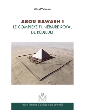
Michel Valloggia
Abou Rawash I. Le complexe funéraire royal de Rêdjedef ( texte + planches ).
Étude historique et architecturale
Depuis près d’un demi-siècle, l’étude des complexes funéraires royaux de l’Ancien Empire a constamment été nourrie par la découverte de nouveaux monuments ainsi que par la reprise des fouilles sur des sites déjà explorés. Curieusement, l’emplacement d’Abou Rawash, au nord-ouest du Caire, n’a fait l’objet d’aucune enquête systématique depuis les brefs travaux que lui avait consacrés É. Chassinat au début du xxᵉ siècle. Or, il est aujourd’hui reconnu que ces vestiges comptent au nombre des rares maillons manquants dans la série des ensembles réétudiés. Cet oubli est d’autant plus surprenant qu’ils regroupent tous les éléments constitutifs des grands tombeaux des souverains de la IVᵉ dynastie.
En dépit des destructions subies et de l’exploitation intensive qui en a été faite depuis l’époque romaine par les carriers, les vestiges conservés offrent l’immense intérêt de présenter de nombreuses ressemblances avec un chantier en construction. Au terme de treize campagnes (1995-2007), une image cohérente de ce lieu de mémoire se dégage désormais, et nombre d’hypothèses anciennes demandent à être reconsidérées.
>>Télécharger le vient-de-paraîtreAbouRawash.pdf (1.02 Mb)
For nearly half a century, the study of royal funerary complexes of the Old Kingdom is constantly being enriched by the discovery of new monuments and by recent excavations on sites, which have been already explored. Oddly enough, since the time of É. Chassinat’s brief work at the beginning of the 20th century, the site of Abu Rawash (North-West of Cairo), has featured very little within this field of study. Yet today, the literature undoubtedly recognizes that these remains constitute a rare and hitherto missing link into the understanding of these complexes. This gap is even more surprising when we consider that Abu Rawash contains all the constitutive elements for large royal tombs of the 4th Dynasty.
Since the Roman period this site been intensively exploited and quarried; however, the preserved remains are of great importance as they represent significant similarities to other building sites.
As a result of thirteen seasons of excavation (1995-2007), the author has amassed comprehensive data on this heritage site, enough to show that previous evaluations will have to be revised.- Michel Valloggia ( : 027175146)
ISBN 9782724705522
2010 IFAO
Collection: FIFAO 61
Langue(s): français
1 vol. 71 p.
29 € (1450 EGP)
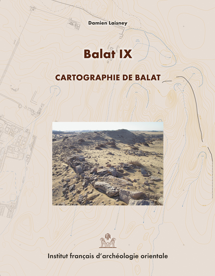
Damien Laisney
Balat IX. Cartographie de Balat
Neuvième volume de la série des fouilles de Balat, cet ouvrage s'articule autour de la publication du plan topographique du site d'Ayn Asil, résidence des gouverneurs de l'oasis de Dakhla à la fin de l'Ancien Empire (vers 2350-2100 av. J.-C.). Bénéficiant des résultats archéologiques acquis depuis le début des fouilles de l'Ifao en 1977, commentée et illustrée de plans, coupes et photographies, cette présentation cartographique du site et de son terroir propose une lecture du terrain ainsi que des phénomènes naturels et anthropiques qui l'ont modelé au cours du temps.
>> Lire la préface.pdf (0.13 Mb)
Published as the ninth volume of the Balat excavations; this book presents the topographical map of the site of Ayn Asil, then residence of the governors of the oasis of Dakhla at the end of the Old Kingdom (ca. 2350-2100 BC). Based on the results of Ifao excavations from 1977 onwards, with the help of comments and illustrations (maps, sections and photographs), this cartographic presentation of the site and its surroundings offers an insight on natural and human prenomena, which have shaped them throughout time.
- Damien Laisney ( : 122830687)
Damien Laisney, topographe, a été membre de l’Institut français d’archéologie de 1996 à 2010. Il a dans ce cadre participé à la plupart des missions archéologiques de l’Ifao, aussi bien dans la Vallée du Nil que dans les déserts arabique et libyque et le Sinaï. Il est rattaché à la Maison de l’Orient et de la Méditerranée de Lyon (CNRS FR 3747).
ISBN 9782724705300
2010 IFAO
Collection: FIFAO 59
Langue(s): français
1 vol. 375 p.
68 € (3400 EGP)
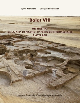
Sylvie Marchand, Georges Soukiassian
Balat VIII.
Un habitat de la XIIIᵉ dynastie – 2ᵉ Période Intermédiaire à Ayn Asil
Ayn Asil was the residence of the Governors of the oasis during the VIth dynasty and was subsequently abandoned around 2100 BC. During the XIIIth dynasty, the southern part of the site is reoccupied with houses constructed upon Old Kingom ruins that have been covered by sand. The fragmentary remains from this settlement consist of three groups of buildings including a large number of storage and food production areas, mostly silos and bakeries. The evidence suggests that these houses represent a hamlet and that it was occupied during a period of relatively slow and partial evolution as determined by the associated ceramic material. The first phase of this evolution can be dated to approximately 1700 BC continuing until a second phase, which can be accurately dated to about 1600 BC.
The comprehensive catalogue of vessels presented, allows us to compare ceramic material from Dakhla with those coming from other well known Egyptian regions, such as they are defined for the Second Intermediate Period.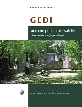
ISBN 9782724705430
2010 IFAO
Collection: FIFAO Archéologie Islamique 60
Langue(s): français
1 vol. 302 p.
54 € (2700 EGP)
Stéphane Pradines
Gedi, une cité portuaire swahilie. Islam médiéval en Afrique orientale
Gedi est une cité médiévale localisée sur les rivages du Kenya actuel, fondée au XIᵉ et abandonnée au début du XVIIᵉ siècle. À l'instar de Zanzibar et de Kilwa, en Tanzanie, Gedi a joué un rôle essentiel dans les relations maritimes de l'océan Indien occidental. Les ports et les cités-États swahilis doivent leur urbanisation aux marchands islamisés perses et arabes venus chercher en Afrique subsaharienne de l'or, de l'ivoire et des esclaves. La ville de Gedi est représentative de la culture swahilie et de l'Islam médiéval en Afrique orientale jusqu'à l'arrivée des Portugais. Les recherches archéologiques de Gedi ont été financées par la Commission des fouilles du ministère des Affaires étrangères et ont reçu un soutien administratif et logistique des Musées nationaux du Kenya et de l'Institut britannique en Afrique de l'Est.
Gedi is a medieval city located ont the coast of the current Kenya. Like many cities such as Zanzibar and Kilwa, in Tanzania, Gedi played an essential role in the maritime relationship of the Western Indian Ocean. The harbours and the Swahilis cities-states owe their urbanization to the Persian an Arabic islamized merchants who came in sub-Saharan Africa to search for gold, ivory and slaves. The city of Gedi was founded in the XIth century and abandoned in the beginning of the XVIIth century. This city is representative of the Swahili culture and medieval Islam in Eastern Africa until the arrival of the Portuguese navigators. The archaeological research in Gedi was founded by the French Ministry of Foreign Affaires (Commission des fouilles) and received an administrative and logistial supprot from the National Museums of Kenya and the British Institute in Eastern Africa.
- Stéphane Pradines ( : 060719532)
Stéphane Pradines est archéologue et professeur d’art et d’architecture islamique à l’Université Aga Khan, Institut pour l’étude des civilisations musulmanes à Londres. Il a dirigé de nombreuses fouilles archéologiques dont les fouilles des murailles du Caire et d’autres fouilles dans l’océan Indien et en Afrique orientale. Il est spécialiste du commerce médiéval dans l’océan Indien, de l’islamisation en Afrique subsaharienne et des cultures matérielles de guerre en Afrique musulmane.
ISBN 9782724704679
2008 IFAO
Collection: FIFAO Fouilles franco-italiennes 55
Langue(s): anglais
1 vol. 370 p.
70 € (3500 EGP)
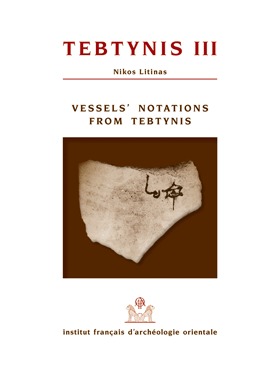
Nikos Litinas
Tebtynis III. Vessel's Notations from Tebtynis (Fouilles franco-italiennes)
This book is the edition of any kind of text written or incised on various types of vessels found at Tebtynis during the excavations of the joined Mission of Università di Milano and Ifao under the directorship of Professor Claudio Galazzi. At present this publication includes treatment of 820 pieces found from 1997 to 2003 mostly in ancient debris deposits of in destroyed layers by the work of previous excavators or farmers.
Considering that this is the first book to group and present these texts, the introduction contains a list of published or described notations of this type from Egypt and a method to identify a text as a "vessel's notation". The majority of these texts consist solely of personal or place names, dates and indications of the content of the vessel, the capacity etc. The date ranges from the second half of the third century BC to the third century AD (with a few in the fourth and fifth century AD). The absolute dating proposed here has been established base on palaeographical details (considering the small amount of texts or the fragmentary character of many of the texts), the stratigraphy and the pottery.
The volume includes photographs of all the published pieces and, where it was possible, a drawing of the vessel type has been made.- Nikos Litinas ( : 128854839)
Nikos Litinas has undertaken research on many aspects of the Classical world, working on a wide variety of topics and utilizing a variety of methodologies and approaches. His research interests include Greek and Latin Documentary and Literary Papyri, Epigraphy, and Classical Philology. He is the author of many books, and has published in several journals, edited volumes, and conference proceedings.
ISBN 9782724704921
2008 IFAO
Collection: FIFAO 58
Langue(s): français
1 vol. 168 p.
30 € (1500 EGP)
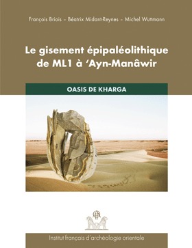
François Briois, Béatrix Midant-Reynes, Michel Wuttmann
Le gisement épipaléolithique de ML1 à 'Ayn-Manâwir. Oasis de Kharga
Le site épipaléolithique ML1 à ‘Ayn Manâwir correspond à un campement localisé sur le rebord oriental d'un petit plateau gréseux dominant le bassin de Douch. La présence de quelques foyers dispersés atteste d'une occupation épisodique, probablement saisonnière, dans le cadre de déplacements sur le territoire de l'oasis de Kharga.
L'outillage lithique, très richement documenté, indique que des activités de débitage de lamelles et de microlamelles pour la fabrication de microlithes géométriques ont été pratiquées sur place pour confectionner des projectiles à éléments composites. Les caractères technologiques de cette production ont été enrichis par de nombreux remontages qui ont permis de préciser les chaînes opératoires. Une industrie de parure en test d'œuf d'autruche est également attestée.
Deux datations 14C placent le site de ‘Ayn Manâwir au milieu du VIIe millénaire. Le faciès microlithique de ML1, où les triangles scalènes et les microburins occupent une place essentielle, est comparable, typologiquement, à la composante «El Ghorab» du Néolithique du Sahara oriental, qui apparaît plus ancienne, au milieu du VIIIe millénaire.
Les puits artésiens, qui ont fonctionné de manière intermittente dans cette région, ont, quelles que soient les conditions climatiques, joué un rôle majeur dans le développement de l'économie de subsistance des populations de chasseurs de cette époque.- François Briois ( : 073320773)
- Béatrix Midant-Reynes ( : 030156963)
Béatrix Midant-Reynes s’est spécialisée dans l’étude de la préhistoire égyptienne. Elle a dirigé, dans le cadre de l’Ifao, plusieurs chantiers de fouilles en Égypte, tous centrés sur la période prédynastique : Adaïma, en Haute Égypte (nécropoles et habitat), Kom el-Khilgan, dans le Delta oriental (nécropole), Tell el-Iswid, dans le Delta oriental (habitat). En 2015, elle a transmis la direction de la fouille de ce site à Nathalie Buchez. De 2000 à 2015, elle a codirigé le volet préhistoire du programme de prospection du bassin sud de Douch (oasis de Kharga). De 2010 à 2015, elle a été directrice de l’Institut français d’archéologie orientale. Elle est actuellement directrice de recherche émérite au CNRS. Parmi les ouvrages publiés, deux sont adressés à un plus large public : Prehistory of Egypt, From the First Egyptians to the First Pharaohs, Londres, 2000, et Aux origines de l’Égypte. Du Néolithique à l’émergence de l’État, Paris, 2003. - Michel Wuttmann ( : 059426268)