Tell el-Herr
| 10.34816/ifao.02cf-768a | |
| 055306985 | |
| Missions Ifao depuis | 1986 |
Mission archéologique franco-égyptienne de Tell-el-HerrAction spécifique 19117
Responsable(s)
![]() Catherine Defernez (CNRS, UMR 8167 (Orient et Méditerranée), équipe « Mondes pharaon)
Catherine Defernez (CNRS, UMR 8167 (Orient et Méditerranée), équipe « Mondes pharaon)
![]() Nathalie Favry (Sorbonne Université - Lettres – UMR 8167 – équipe Mondes Pharaonique)
Nathalie Favry (Sorbonne Université - Lettres – UMR 8167 – équipe Mondes Pharaonique)
Partenaires
Cofinancements
Dates des travaux
octobre - novembre
Rapports de fouilles dans le BAEFE
2022 : 10.4000/baefe.9011
2021 : 10.4000/baefe.6113
2020 : 10.4000/baefe.2870
2019 : 10.4000/baefe.772
Participants en 2026
| Catherine Defernez | archéologue | CNRS, UMR 8167 (Orient et Méditerranée), équipe « Mondes pharaon | |
| Nathalie Favry | égyptologue, ingénieur d'études | Sorbonne Université - Lettres – UMR 8167 – équipe Mondes Pharaonique |
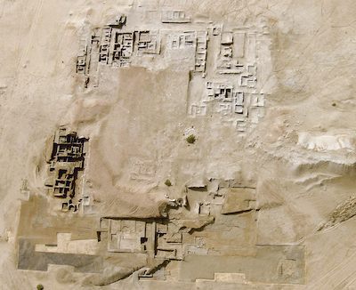
Aerial view of the Tell during Spring 2010.
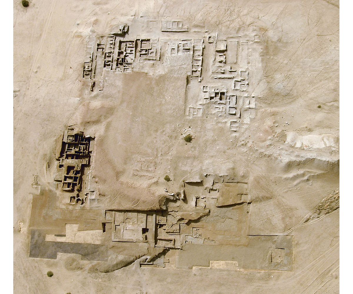
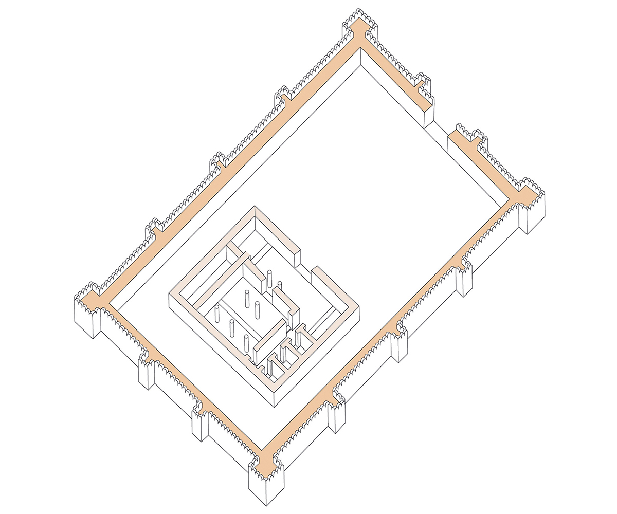
Reconstruction of the Tell el-Herr palace complex.
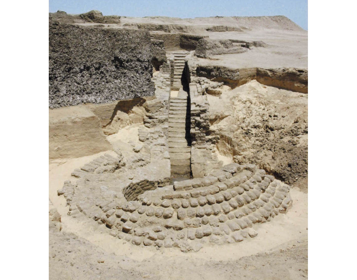
Hypogeum construction of the first half of the 5th century BC, north-east corner of the Tell.
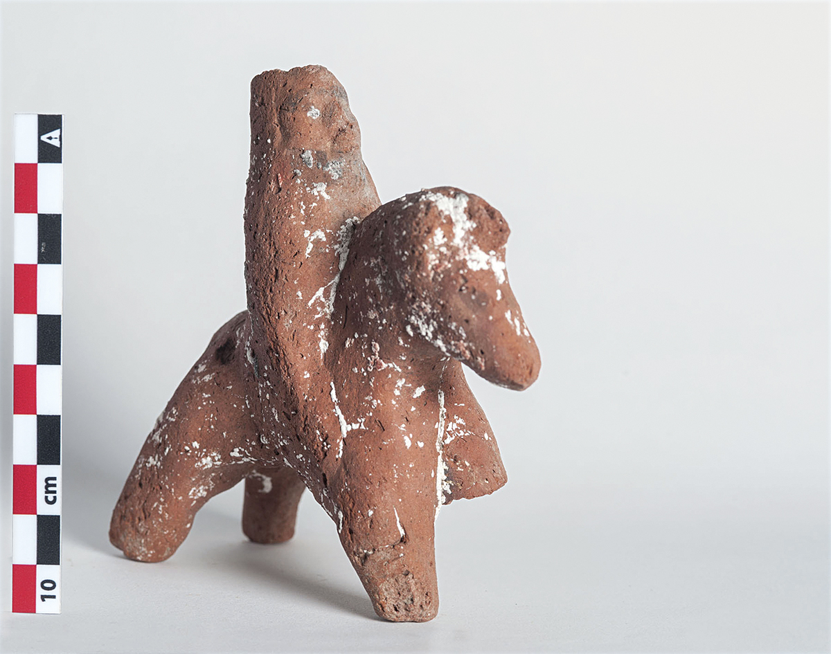
Persian rider in terracotta.
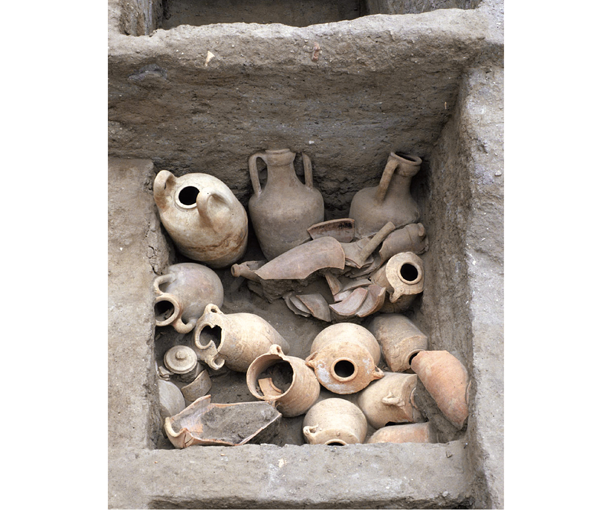
Amphorae deposit from the middle of the 5th century BC.
© Mission franco-égyptienne de Tell el-Herr.
C’est dans le cadre du North Sinai Agricultural Development Project (NSADP), mis en œuvre en 1986, en faveur du développement de terres agricoles et irrigables dans la région, et la construction du canal de la paix (El-Salam canal) – reliant la ville actuelle d’El-Arish au delta du Nil – que la mission franco-égyptienne, sous la coresponsabilité de Dominique Valbelle et du Dr. Mohamed Abd el-Maksoud, a débuté ses activités sur le site de Tell el-Herr puis, plus extensivement, en 1992, dans la basse région pélusiaque, sous l’égide de l’Unesco et du ministère des Antiquités égyptiennes (projet archéologique de sauvetage du Nord-Sinaï). Favorisée par une position géographique privilégiée, à proximité du littoral méditerranéen, de la branche pélusiaque et de la route terrestre reliant l’Égypte à la Palestine (les « Chemins d’Horus »), la région accueillit, dès les débuts de son histoire, un réseau de fortins destiné à protéger la frontière la plus orientale du Delta des incursions venues de l’Est. Une succession de postes-frontières s’est ainsi développée progressivement le long du cordon littoral, en bordure des lagunes saumâtres formées lors de la transgression flandrienne, à proximité de l’actuelle ville de Qantara (Tell Héboua et Tell el-Borg, notamment), dans un premier temps, puis, plus à l’est, non loin de l’antique cité de Péluse, dans un second temps. Au cours du Ier millénaire, s’établirent donc successivement les garnisons de Tell el-Ghaba, de Kédoua/T. 21 et de Tell el-Herr.
Situé à 35 km à l’est du canal de Suez, à proximité du village actuel de Gilbana, le site de Tell el-Herr est avant tout un poste-frontière (Migdol/Magdolum), édifié au cours de la première moitié du ve s. av. J.-C., sous la XXVIIe dynastie achéménide. Les investigations conduites sur le site, dès les débuts du NSADP, en 1986, par la mission franco-égyptienne, ont révélé plusieurs forteresses successives, associées à des quartiers d’habitations et des bâtiments imposants, édifiés en briques crues, au cours des ve et ive s. av. J.-C.
La première enceinte, à redans, formant un quadrilatère d’environ 140 m de côté, probablement mise en œuvre au début du ve s. av. J.-C., fut partiellement dégagée sur son pourtour oriental, lors des premières campagnes de fouilles, tout comme les unités d’habitation, sanctuaires de plan atypique (niches axiales et autel central) et vastes complexes de stockage contemporains (dont des celliers pouvant contenir des dizaines d’amphores à vin et à huile), mis au jour dans les secteurs particulièrement éprouvés par les destructions des occupations militaires récentes. Entièrement bâtie en briques cylindriques, la seconde forteresse, agrandie (200 m de côté), qui lui succéda dans les dernières décades du ve s. av. J.-C. et qui connut plusieurs réfections au ive s. av. J.-C., abrita plusieurs îlots d’habitations accessibles par un réseau régulier de rues, des espaces cultuels ainsi que d’imposants bâtiments sur plateforme cellulaire, de nature religieuse ou administrative. Dans son angle nord-ouest, un édifice de type palatial aux caractéristiques architecturales atypiques, proche-orientales, introduit par une cour à portiques desservant une longue salle d’apparat et ses annexes, ainsi qu’une série de magasins, fut aménagé.
En 2010, juste avant l’arrêt momentané des travaux sur le terrain, le dégagement et l’étude de l’entrée principale de la forteresse perse, à l’est du tell, ont conduit à la découverte d’une construction hypogée de forme circulaire, en brique crue, abritée par une coupole et accessible par une longue rampe d’escaliers de 5 m de haut. Contemporain de la fondation de la forteresse dans le deuxième quart du ve s. av. J.-C., cet édifice évoquant fortement les tholoï de type macédonien a, semble-t-il, été pillé lors de la construction de la seconde enceinte qui le scellait partiellement.
Outre des vestiges de l’époque perse, une nécropole, un bain et une vaste agglomération, datés de l’époque ptolémaïque, couvrant une quinzaine d’hectares en contrebas du tell, puis un fortin romain du Bas-Empire, sur le haut du tell, ont été mis au jour.
De par sa position stratégique, en connexion des réseaux maritimes et fluviaux sis à proximité, le site de Tell el-Herr a, semble-t-il, assumé dès sa fondation une double vocation, militaire et économique. La documentation abondante collectée, à l’issue des dégagements de divers secteurs du tell, suggère des activités économiques et commerciales denses entre la basse région pélusiaque et les centres majeurs du bassin méditerranéen oriental. La variété des artefacts (bijoux, amulettes, lithique, coroplathie, armes, etc.) et des productions céramiques témoigne de la richesse de la culture matérielle de ce site (grecque, phénicienne, perse, égyptienne, chypriote).
En raison de la situation d’insécurité qui prévaut dans le nord du Sinaï depuis 2011, les interventions sur le terrain sont momentanément interrompues. La mission concentre donc ses efforts sur la préparation des publications d’une phase importante de l’histoire du site, relative aux niveaux de la fin du Ve et du IVe s. av. J.-C. Elle a pour objectif, depuis l’automne 2016, de poursuivre l’étude du mobilier archéologique, aujourd’hui conservé dans les magasins des Antiquités égyptiennes de la ville actuelle de Sân el-Hagar.
Dans le cadre des activités de la mission, une coopération soutenue avec l’inspectorat du Nord-Sinaï (MoA), opérant sur les sites de Tell Héboua I, Tell Héboua II et Tell el-Farama, est toujours assurée. Cette collaboration s’est récemment manifestée, en marge de l’inauguration du doublement du canal de Suez, par l’organisation commune de trois expositions et d’un ouvrage.
Catherine Defernez (CNRS, UMR 8167)
It was from 1986, under the co-directorship of Dominique Valbelle and Dr. Mohammed Abd el-Maksoud, that the Franco-Egyptian mission began its activities at the site of Tell el-Herr as part of the framework of the North Sinai Agricultural Development Project (NSADP). The aim of this programme was to aid the development of land for agriculture and irrigation in the region and the construction of the canal of peace (El-Salam canal) linking the current town of El-Arish with the Nile Delta. More extensive activities were conducted in 1992 in the lower Pelusiac region under the aegis of UNESCO and the Egyptian Ministry of Tourism and Antiquities (the archaeological rescue project of North-Sinai). With its significant geographic position near the Mediterranean coast, the Pelusian branch of the Nile and the overland route linking Egypt to Palestine (the “Ways of Horus”), from the beginning of its history, the region had featured a network of forts created to protect the most easterly frontier of the Delta from incursions from the East. A succession of frontier-posts was therefore progressively constructed along the coastal strip, on the edge of brackish lagoons formed during the first phase of the Holocene glacial retreat, close to the town of Qantara (in particular Tell Hebua and Tell el-Borg); and during a second phase, more to the east, not far from the ancient city of Peluse. During the 1st millennium BC garrisons at Tell el-Ghaba, Kedua/T.21 and Tell el-Herr were established, one after the other.
Situated 35 km to the east of the Suez Canal, near the modern-day village of Gilbana, the site of Tell el-Herr functioned above all as a frontier-post (Migdol/Magdolum) which was constructed during the first half of the 5th century BC, during the Achaemenid 27th Dynasty. The investigations conducted by the Franco-Egyptian mission at the site in 1986 (from the start of the NSADP), revealed several successive fortresses which included imposing mud-brick buildings built during the course of the 4th and 5th centuries BC.
The first stepped enclosure, which formed a quadrilateral with sides about 140 m long, was probably constructed at the beginning of the 5th century BC. This was partially cleared on its eastern periphery during the first seasons of excavation. Also cleared were residential areas, temples with an atypical plan (axial niches and central altar) and huge, contemporaneous storage facilities whose cellars could contain dozens of wine and oil amphorae (these were unearthed in areas which had been particularly subject to destruction by recent military occupation). Entirely constructed of cylindrical bricks, a second, enlarged fortress, (with sides measuring 200 m) succeeded it in the last decades of the 5th century BC. This experienced several enlargments in the 4th century BC, and incorporated several blocks of dwellings accessed through a regular network of streets, cultic spaces as well as imposing buildings with a religious or administrative nature built on a cellular platform-foundation. At the north-west corner, a palatial-type of structure, with atypical, Near-Eastern, architectural characteristics, was accessed through a porticoed court which led to a long ceremonial room with annexes, as well as to a series of magazines.
In 2010, just before the temporary cessation of field work, the clearing and study of the main entrance to the Persian fortress at the east of the tell led to the discovery of a hypogeum structure, circular in shape, made of mud-bricks, covered by a dome and accessed by a long set of stairs reaching to a height of 5 m. Contemporary with the foundation of the fortress in the second quarter of the 5th century BC, this structure strongly resembles the Macedonian type of tholoï. This apparently had been looted when the construction of the second enclosure wall partly sealed it.
Besides the remains of the Persian period, a necropolis, bath and a huge settlement were unearthed below the tell which date to the Ptolemaic period and cover about fifteen hectares, as well as a Roman fort of the Late Empire on top of it.
Due to its strategic position, being connected closely to maritime and fluvial networks, the site of Tell el-Herr, from its foundation, had apparently played a double role: military and economic. The abundant data gathered through the clearance of different areas of the tell, suggest intense economic and commercial activity between the lower Pelusiac region and major centres of the eastern Mediterranean basin. The variety of artefacts (jewellery, amulets, lithic implements, clay figurines, weapons etc.) and ceramic items attest to the diversity of material culture at this site that was Greek, Phoenician, Persian, Egyptian and Cypriot.
Due to the insecure situation which has prevailed in northern Sinai since 2011, fieldwork excavations have temporarily been suspended. The mission therefore is concentrating its efforts on preparing the publication of an important phase of the site’s history relating to the end of the 5th and the 4th century BC. Since 2016 its aim has been to conduct a study of the archaeological material today stored in Egyptian Antiquities’ magazines in the town of San el-Hagar.
Within the framework of the mission’s activities, in co-operation with the North-Sinai Inspectorate (MoTA), work at the site of Tell Hebua I, Tell Hebua II and Tell el-Farama has been sustained. During the recent inauguration of the enlargement of the Suez Canal, this collaboration was been highlighted by the joint organisation of three expositions and a monograph.
Catherine Defernez (CNRS, UMR 8167)
في إطار مشروع شمال سيناء للتنمية الزِّراعيَّة، والذي بدأ تنفيذه في عام ١٩٨٦ بهدفِ تطويرِ الأراضي الزراعيَّةِ والصالحةِ للرَّيّ في المنطقة، وشقِّ ترعةِ السلام - لربطِ مدينة العريش الحاليَّة بدلتا النيل - بدأت البَعْثَةُ الفرنسيَّة-المصريَّة، تحت المسئوليَّةِ المشتركةِ لكُلٍّ من دومينيك ﭬﺎلبيل ود. محمد عبدالمقصود، أنشطتَها في موقعِ تَلِّ الحِير، ثم على نطاقٍ أوسع، في عام ١٩٩٢، في المنطقةِ السُّفلَى من بيلوز (الفَرَما حاليًّا)، تحت رعايةِ مُنظَّمةِ اليونسكو ووزارةِ الآثارِ المصريَّة (المشروع الأثريَ لإنقاذ شمال سيناء). وبفضلِ موقعِ هذه المنطقةِ الجغرافيّ المُتميِّز، ووقوعِها على مقربةٍ من ساحلِ البحرِ المتوسط، من الفرعِ البيلوزي، ومن الطريق البرِّيّ الذي يربط مصر بفلسطين («طريق حورس»)، استقبلت المنطقةُ، منذ بدايةِ تاريخها، شبكةً من التحصيناتِ المُخصَّصةِ لحمايةِ أقصى الحدودِ الشرقية للدلتا من الغاراتِ القادمةِ من الشرق. وتطوَّرت، في هذا السياق، سلسلةُ من المراكز الحُدوديَّة تدريجيًّا على طولِ اللسانِ الساحليّ، عند حافَةِ البُحيراتِ المالحةِ التي تشكّلت إبَّانَ فترةِ الطغيانِ الفلاندريّ، بالقربِ من مدينةِ القنطرةِ الحاليَّة (تل حبوة، وتل البرج على وجه الخصوص)، ذلك في مرحلةٍ أولى، ثم في مرحلةٍ ثانيةٍ شرقًا، بالقربِ من مدينة بيلوز القديمة. وعلى مدارِ الألفيَّةِ الأولى، أُقيمت تِباعًا حامياتُ تلِّ الغابة، وكدوة/ت ٢١ وتل الحِير.
يقعُ موقعُ تلِّ الحِير على بُعد ٣٥ كيلومترًا، شرقَ قناةِ السويس، بالقربِ من قريةِ جلبانة الحاليَّة، وهو قبل كُلِّ شيء، مركزٌ حدوديٌّ (مجدول/ماجدولوم)، بُنِيَ خلالَ النصفِ الأولِ من القرنِ الخامسِ قبل الميلاد، في عهدِ الأسرة السابعة والعشرين الأخمينيَّة. كشفت المُسُوحاتُ التي أُجرتها البَعْثةُ الفرنسيَّة-المصريَّة في الموقع، منذ بدايةِ مشروعِ شمال سيناء للتنمية الزراعيَّة عام ١٩٨٦، عن الكثير من الحُصُون المتتالية، المرتبطةِ بأحياء سكنيَّةٍ ومبانٍ ضخمة، بُنيت من الطوب اللَّبِن، خلال القرنين الخامس والرابع ق. م.
السورُ الأولُ ذو حَيْدٍ [بروز في سورِ حصن]، له شكلٌ رباعيٌّ، حيثُ يبلغُ قياسُ كُلِّ جانبٍ قرابة ١٤٠ مترًا، ربما بُنِيَ في أوائلِ القرنِ الخامسِ قبل الميلاد. وقد تم إظهاره جُزئيًّا في محيطهِ الشرقيّ أثناءَ بعثاتِ التنقيبِ الأولى. كذلك، تم إظهار الوحداتُ السكنيَّة، والأماكن المُقدَّسة ذات التخطيط غير النَّمطيّ (كَوَّات مِحْوريَّة ومَذْبَح مركزيّ)، ومُجمَّعات معاصرة واسعة مُخصَّصة للتخزين (بما في ذلك بيوت المُؤَن التي قد تحتوي على العشرات من أمفورات الخمر والزيت)، والتي كُشِفَ عنها في المناطقِ المتأثرةِ بشكلٍ خاصٍّ بتدميرات الاحتلال العسكرىّ الأخير. بُنِيَ الحصنُ الثاني بالكاملِ من الطوبِ الأسطوانيّ، تمَّ توسيعه (٢٠٠ متر من كل جانب). حلَّ هذا الحصنُ الثاني محلَّ الحصنِ الأولِ في العقودِ الأخيرةِ من القرن الخامس قبل الميلاد، وشهد الكثيرَ من الإصلاحاتِ خلالَ القرن الرابع قبل الميلاد؛ حيث كان يضمُّ عدَّةَ مجموعاتٍ من المساكنِ التي يمكنُ الوصولُ إليها عن طريقِ شبكةٍ منتظمةٍ من الشوارع، والأماكن الشعائريَّة؛ وكذلك مبانيَ ضخمةً مُقامةً على مِنصَّةٍ خلويَّةٍ ذاتِ طابَعٍ دينيّ أو إداريَ. وفي الركنِ الشماليّ الغربيّ، تمَّ تجهيزُ بناءٍ على طرازٍ فخمٍ بمميَّزاتٍ معماريَّةٍ غير نمطيَّة، ذي علاقةِ بالشرقِ الأدنى، يسبقه فناءُ بأروقةٍ يخدمُ قاعةَ احتفالاتٍ طويلةً وملحقاتها؛ وكذلك سلسلةٌ من المخازن.
في عام ٢٠١٠، قُبَيل التوقُّف المؤقَّت للعمل الميدانيّ، أسفر الكشف عن ودراسةُ المدخل الرئيس للحصن الفارسيّ، شرق التَّلِّ، عن اكتشافِ بناءٍ جوفيٍّ بشكلٍ دائريٍّ من الطوب اللَّبِن مُحاطًا بقُبَّة، ويمكن الوصولُ إليه من خلال دَرَجٍ طويلٍ مُنحدر، بارتفاع ٥ أمتار. هذا البناءُ معاصرٌ لتأسيس الحصنِ خلال الرُّبْع الثاني من القرن الخامس قبل الميلاد، ويشير بقوَّةٍ إلى اﻟـ « ثولوس» [مقبرة على شكل خليَّة نحل] من الطِّراز المقدونيّ، ويبدو أنه نُهِبَ أثناء بناء السور الثاني الذي كان يُغلقُه جزئيًّا.
بالإضافة إلى بقايا الحقبة الفارسيَّة، فقد تمَّ الكشفُ عن جبَّانة، وحمَّام، وتَجمُّعات سكانيَّة كبيرة، تؤرِّخ للعصر البطلميّ، وتغطي خمسةَ عشرَ هكتارًا أسفل التل، ثم حصنٍ رومانيٍّ صغيرٍ على قمَّة التل يرجعُ إلى المرحلة الأخيرة للإمبراطوريَّةِ الرومانيَّة.
وبسبب موقعه الاستراﺘﻴﭼﻰّ، متصلًّا بالشبكاتِ البَحْريَّة والنَّهْريَّة القريبة الكائنة، يبدو أن موقعَ تَلِّ الحِير قد تولَّى منذ تأسيسه مَهمَّةً ذات بُعدين: عسكرىّ واقتصادىّ. تشيرُ الوثائقُ الوفيرةُ التي جٌمعت، بعد الانتهاء من كشف مناطق مختلفة من التل، إلى أنشطةٍ اقتصاديَّةٍ وتجاريَّةٍ كثيفةٍ بين المنطقة البيلوزيَّة السُّفلَى والمراكز الرَّئيسةِ لحوضِ شرق البحر المتوسط. يشهدُ تنوُّعُ مجموعةِ القطعِ الأثريَّة (مجوهرات، وتمائم، وحجريَّات، وطين محروق، وأسلحة، إلخ) والمنتجات الخَزَفيَّة، على ثراء الثقافة الماديَّة لهذا الموقع (يونانيَّة، فينيقيَّة، فارسيَّة، مصريَّة، قبرصيَّة).
وبسبب الأوضاعِ غير الآمنة في شمال سيناء منذ عام ٢٠١١، توقَّفت الأنشطةُ الميدانيَّة بصورةٍ مؤقَّتة. وتُركِّز البَعْثةُ جهودَها على نشر مرحلةٍ مُهمَّةٍ من تاريخِ الموقع، متصلة بنهاية القرنين الخامس والرابع قبل الميلاد. ومنذُ خريفِ ٢٠١٦، تهدفُ البعثةُ إلى مواصلةِ دراسةِ المنقولات الأثريَّة، المحفوظةِ الآن في مخازنِ الآثارِ المصريَّةِ لمدينةِ صان الحجر الحاليَّة.
وفي إطارِ أنشطةِ البعثةِ، هناك دائمًا تعاونٌ مع تفتيشِ آثارِ شمالِ سيناءَ العاملِ في مواقعِ تَلِّ حَبْوَة الأول، تَلِّ حَبْوَة الثاني، وتل الفَرَما. وقد تجسَّدت هذه المشاركةُ مؤخَّرًا من خلالِ تنظيمٍ لثلاثةِ معارضَ مًشترَكة وإعدادِ مطبوعات على هامشِ افتتاحِ قناةِ السُّويْسِ الجديدة.
كاترين ديفرنيز (المركزُ الوطنيُّ للبحث العلميّ، UMR 8167)
Bibliographie
- D. Valbelle, J.-Y. Carrez-Maratray ; avec la collaboration de C. Bonnet, contributions de P. Ballet, L. Chaix, G. Wagner et J.-M. Willot, Le camp romain du Bas-Empire à Tell el-Herr. Mission franco-égyptienne de Tell el-Herr (Nord-Sinaï), Paris, 2000.
- D. Valbelle (dir.) ; avec les contributions de M. Abd el-Maksoud, P. Ballet, J.-Y. Carrez-Maratray, L. Chaix, M. Chauveau, C. Defernez, D. Dixneuf, N. Favry, T. Fournet, F. Leclère, S. Marchi, E. Fathy, M.-D. Nenna, G. Nogara, B. Redon et D. Valbelle, Tell el-Herr. Les niveaux hellénistiques et du Haut-Empire. Mission franco-égyptienne de Tell el-Herr (Nord-Sinaï), Paris, 2007.
- A. Minaut-Gout, N. Favry, N. Licitra, Une résidence royale égyptienne. Tell Abyad à l’époque ramesside, Passé-Présent, Paris, 2012.
- S. Marchi, L’habitat dans les forteresses de Migdol (Tell el-Herr) durant les ve et ive siècles avant J.-C. Étude archéologique, Passé-Présent, Paris, 2014.
- C. Defernez, G. Nogara, D. Valbelle ; avec les contributions de P. Ballet, L. Chaix, N. Favry, S. Marchi, J. Masquelier-Loorius et É. Rotté, Tell el-Herr. Les niveaux de la fin du ve siècle et du ive siècle av. J.-C. I. Un palais oriental à Migdol. Mission franco-égyptienne de Tell el-Herr, Passé-Présent, Paris, 2017.