Qous
| 10.34816/ifao.d2e3-d15a | |
| 127638016 | |
| Missions Ifao depuis | 2017 |
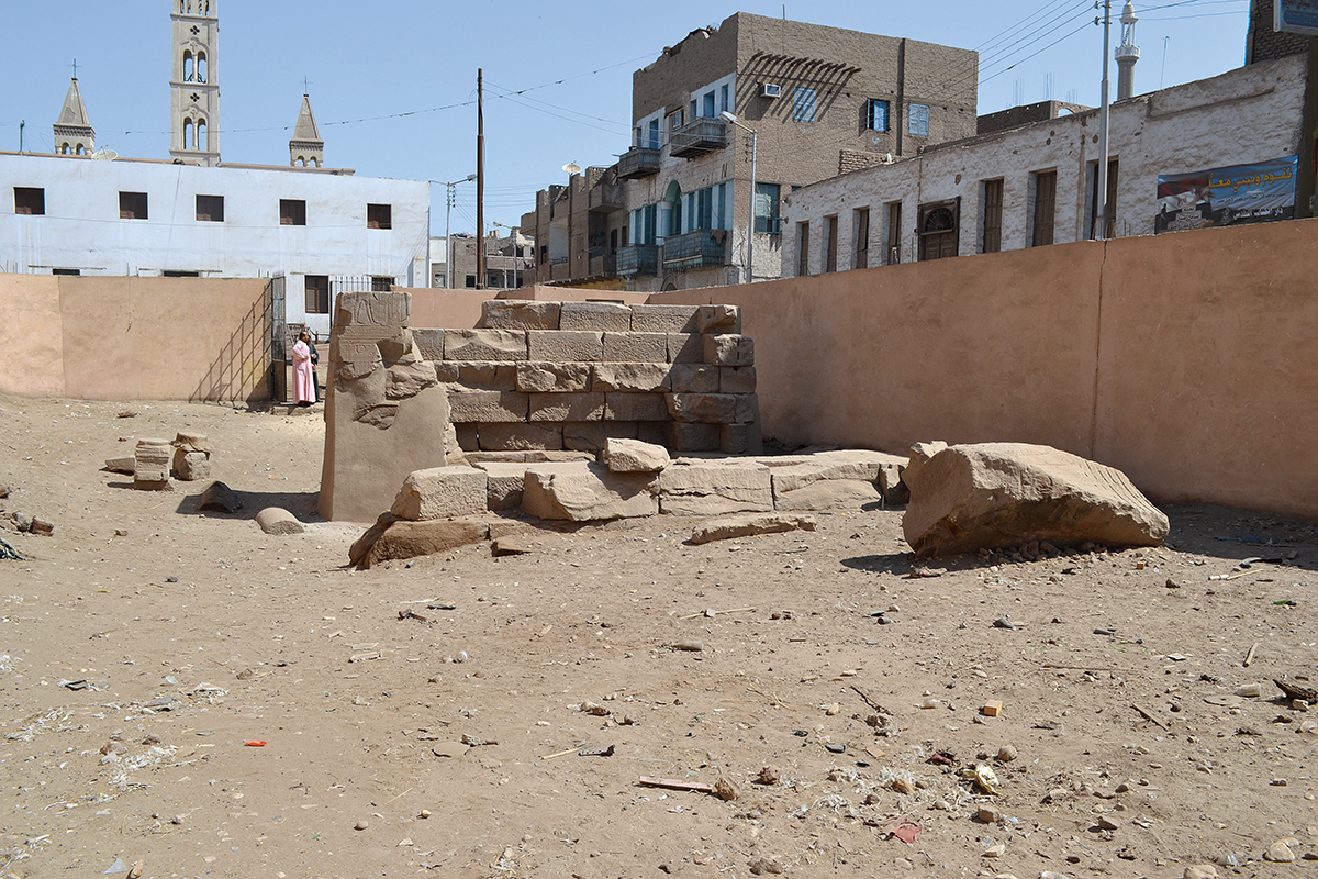
Qus, east-west view of the Western Gateway (2nd century BC–1st century AD).
Qus, west-east view of the Western Gateway (2nd century BC–1st century AD.
© Mission Qous.
Qus, north-south view of the Eastern Gateway (2nd century BC).
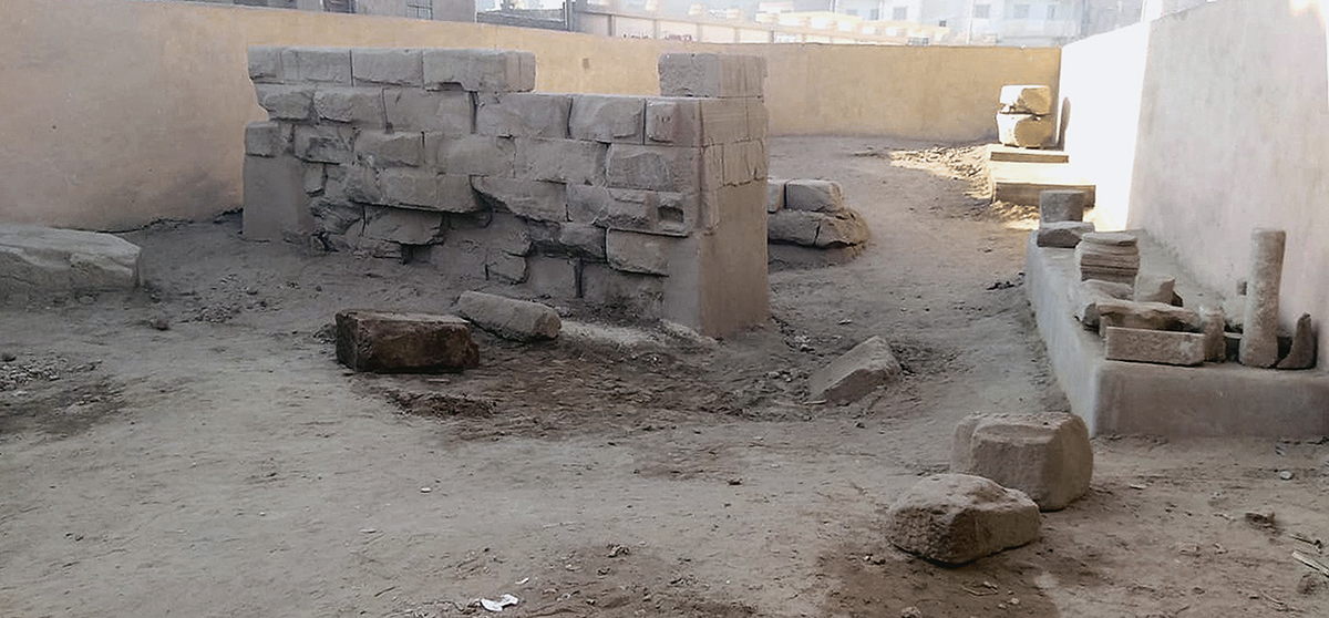
Qus, south-north view of the Eastern Gateway (2nd century BC).
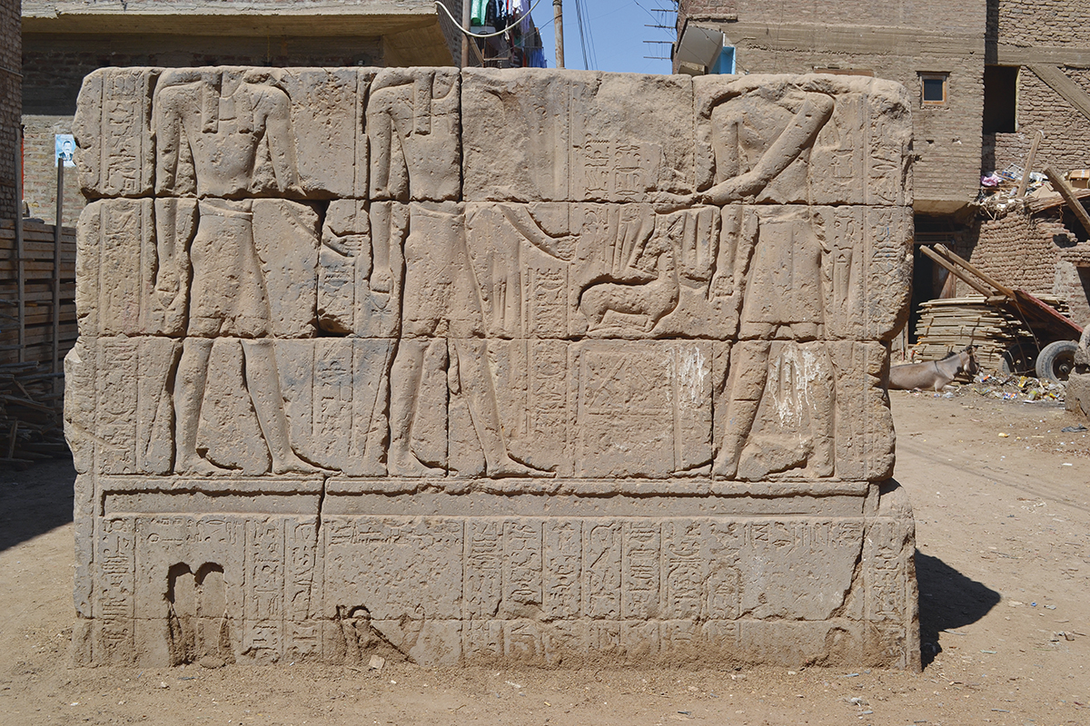
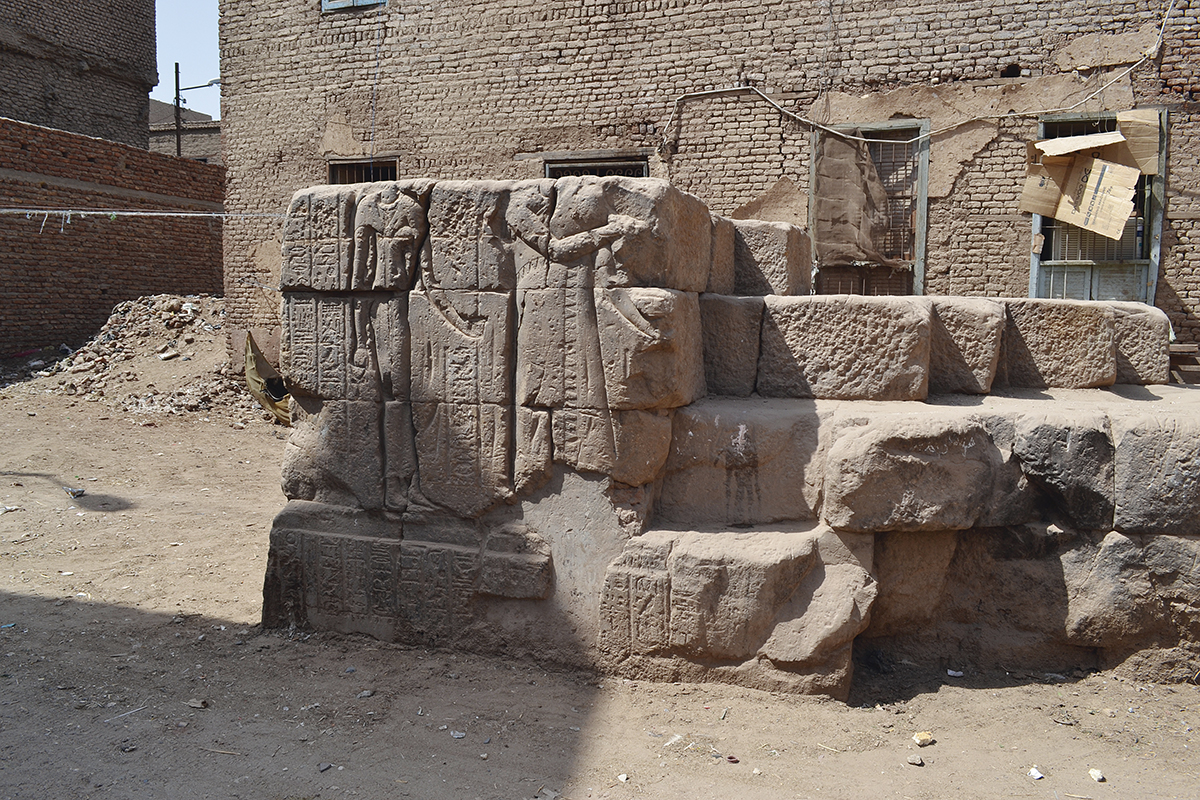
Qus, western half of the southern frame of the Western Gateway: scene of offering to the ancestral Ptolemies.
Environnement géographique
Qous, dont le nom actuel vient du toponyme antique Gesy, hérita des temps anciens sa prospérité et les avantages de sa localisation. Grâce à la déviation du Nil formant un coude, la distance entre la Vallée et la mer Rouge est, en ce point, la plus réduite de toute la côte maritime. La dépression naturelle du Ouadi Hammamat, depuis longtemps aménagé de puits et de voies de circulation, facilitait la traversée du désert montagneux. Située à l’entrée du ouadi, Qous profitait de l’exploitation de ses mines d’or et de ses carrières de pierres dures (granit, quartz, grauwacke), ainsi que des expéditions commerciales vers le Pays de Pount, d’où l’on ramenait notamment les précieux arbres à encens. Bien que Coptos était la capitale du 5e nome de Haute Égypte à l’époque pharaonique, Qous fut sans doute la seconde ville de la province. Elle conserva un rôle prépondérant jusqu’à l’époque médiévale, se trouvant au carrefour de la route des épices entre l’Inde et l’Europe et sur le chemin des pèlerins de l’Afrique du nord.
Dieux et mythes
De l’ancienne ville pharaonique, on n’observe plus aujourd’hui que les ruines du temple du dieu local Haroéris. Frère d’Osiris et d’Isis, Haroéris fait partie des figures majeures du panthéon égyptien. Il a donné son nom à la ville à l’époque grecque que l’on nommait alors Apollinopolis Micra. Les vestiges visibles de son temple datent des époques ptolémaïque et romaine (150 av.-50 apr. J.-C.), mais d’autres sources attestent le culte du dieu dès 1500 av. J.-C. Huit autres divinités étaient également vénérées à Qous : Héqet, Khonsou, Osiris, Isis, Nephthys, Chou, Tefnout et Sobek.
Le temple d’Haroéris était consacré à la naissance du dieu, mis au monde par sa mère la déesse-grenouille Héqet. Il s’inscrit dans le groupe formé par les cinq lieux de naissance des cinq enfants de Geb et de Nout : Thèbes (Osiris), Qous (Haroéris), Ombos (Seth), Dendara (Isis) et Hou (Nephthys). Seuls Karnak, Dendara et Qous ont conservé les vestiges des sanctuaires associés. La théorie de ces cinq lieux de naissance, mise en regard avec celle des jours épagomènes – dates de naissance des dieux –, constitue un cas intéressant de géographie religieuse.
Le patrimoine archéologique
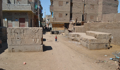
Au cœur de la ville moderne de Qous, on peut observer deux portes monumentales marquant l’entrée du temple d’Haroéris, aujourd’hui enseveli sous un kôm occupé par de vieux habitats du XIXe s. Distantes d’environ 50 m, elles sont partiellement enterrées et ont perdu leur partie supérieure. Leur décor a été réalisé aux noms de Ptolémée VIII Évergète II, de Ptolémée X Alexandre Ier et de l’empereur Claude.
À une vingtaine de mètres des portes, l’ancien kôm archéologique a livré les vestiges d’un baptistère et d’habitats byzantins ayant remployé plusieurs blocs pharaoniques. Sa localisation par rapport aux portes suggère que ce secteur renferme au moins une partie du temple d’Haroéris. La mosquée el-Amri, toute proche, possède également des remplois de chapiteaux et de colonnes romaines.
Historique des fouilles
Aux XVIIIe et XIXe s., les voyageurs n’ont observé qu’une seule des deux portes, conservée dans sa totalité. En 1898, Ahmed Bey Kamal procéda à un dégagement partiel des deux portes qui avaient déjà perdu leur partie supérieure. Il releva également les inscriptions hiéroglyphiques des deux registres de scènes préservés. À l’exception des travaux réalisés dans le secteur byzantin par une équipe égyptienne dans les années 1990, aucune fouille n’a été menée sur le site, en particulier autour des portes ptolémaïques aujourd’hui menacées par la proximité des habitations modernes.
Créée en 2016 et codirigée par Anaïs Tillier (université Montpellier 3) et Dr. Ali Abdelhalim Ali (université d’Ayn Chams), la Mission Qous a pour objectif l’étude, la protection et la mise en valeur de son patrimoine antique. Ses résultats seront publiés dans les collections scientifiques et, à terme, le programme de restauration et de valorisation des monuments offrira des perspectives sociales et économiques à la ville avec l’ouverture du site au public et son intégration dans les circuits touristiques.
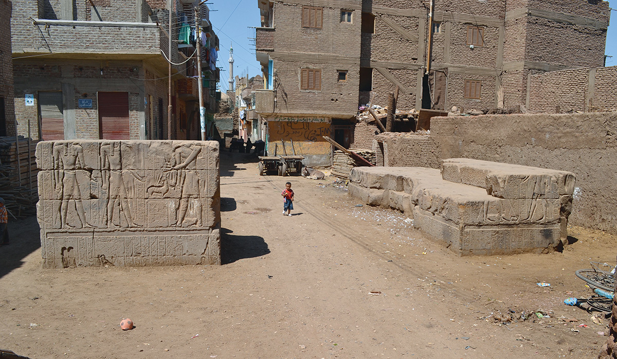
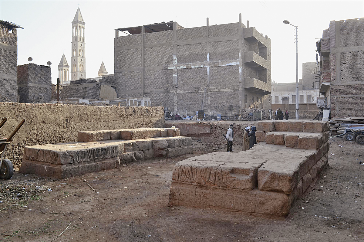
Deux missions ont été menées en 2017 et 2019 grâce aux appuis financiers et logistiques de l’Ifao, du fonds Khéops pour l’archéologie et du CFEETK. Les travaux menés sur le terrain ont permis de commencer le déplacement des blocs épars situés dans le secteur de la porte orientale. Des banquettes ont été construites pour accueillir les imposants fragments de la corniche à gorge qui ornait le sommet de la porte. Ces travaux seront achevés pendant la prochaine campagne, en janvier 2020. Son objectif sera également d’acquérir de la documentation en vue de la publication des inscriptions et du décor des monuments.
Anaïs Tillier (université Montpellier 3, UMR 5140)
Geographic environment
Qus, whose modern name derives from the ancient toponym Gesy, inherited from ancient times its prosperity and the benefits of its location. Thanks to a deviation in the Nile, which forms a bend, the distance between the Valley and the Red Sea along the maritime coast is at its shortest at this point. The natural depression of the Wadi Hammamat, with its wells and roadways, for a long time has facilitated the crossing of the mountainous desert. Located at the entrance of the wadi, Qus profited from the exploitation of its gold mines and its quarries of hard stone (granite, quartz and greywacke) as well as commercial expeditions heading towards the Land of Punt from where precious incense trees would be brought back. Although Coptos was the capital of the 5th nome of Upper Egypt during the Pharaonic period, Qus was without doubt the second-most important town of the province. Being located at the crossroads of the spice route between India and Europe and on the way for pilgrims of North Africa, it preserved its significant role up to the Medieval period.
Gods and myths
Today the only remains still visible of the pharaonic city are the ruins of the temple of the local god Haroeris. Brother of Osiris and Isis, Haroeris was a major figure in the Egyptian pantheon. He gave his name to the city during the Greek period when it was called Apollonopolis Micra. The visible remains of his temple date to the Ptolemaic and Roman periods (150 BC-AD 50), although other sources attest to the cult of the god from 1500 BC. Eight other divinities were also venerated at Qus: Heqet, Khonsu, Osiris, Isis, Nephthys, Shu, Tefnut and Sobek.
The temple of Haroeris was dedicated to the birth of the god, brought into the world by his mother, the frog-goddess Heqet. It is incorporated within the group formed by the five birth-places of the five children of Geb and Nut: Thebes (Osiris), Qus (Haroeris), Ombos (Seth), Dendara (Isis) and Hu (Nephthys). Only at Karnak, Dendara and Qus do remains of their associated temples survive. The theory relating to the five birth-places, which link with the five epagomenal days (the birth dates of the gods), constitutes an interesting example of religious geography.
Archaeological heritage
In the middle of the modern city of Qus two monumental gateways can be observed which mark the entrance to the temple of Haroeris, which is today buried under a kom occupied by old dwellings of the 19t century. Approximately 50 m apart, they are partially buried and have lost their upper sections. Their decoration bears the names of Ptolemy VIII Euergetes II, Ptolemy X Alexander I and the Emperor Claudius.
About 20 m from the gateways, the ancient archaeological kom includes remains of a baptistry and Byzantine dwellings in which several pharaonic blocks were reused. Its proximity to the gateways suggests that this area incorporates at least part of the temple of Haroeris. The nearby El-Amri mosque, similarly incorporates reused items, including capitals and Roman columns.
History of excavations
In the 18th and 19th centuries, travellers only commented on one of the two gateways, which was then completely preserved. In 1898 Ahmed Rey Kamal undertook a partial clearance of the two gateways which had by then lost their upper portion. He recorded the hieroglyphic inscriptions of the two preserved registers of scenes. With the exception of the work conducted in the Byzantine area by an Egyptian team in the 1990s, no excavation has been conducted at the site, especially around the Ptolemaic gateways, which are today threatened by their proximity to modern dwellings.
Created in 2016 and co-directed by Anaïs Tillier (University of Montpellier) and by Dr. Ali Abdelhalim Ali (University of Ain Shams), the Mission Qus aims to study, protect and enhance its ancient heritage. Its findings will be published in scholarly publications, and a programme of restoration and enhancement of the monuments will offer social and economic perspectives on the city. In the future, the site could be opened to the public and integrated within the tourist circuit.
In 2017 and 2019, two missions were conducted thanks to the financial and logistical support of the IFAO, the CFEETK and financial assistance from Kheops Fund for Archaeology. Fieldwork has enabled scattered blocks situated in the area of the eastern gateway to be moved. Benches have been constructed to accommodate the substantial fragments of the cornice that once adorned the top of the gateway. This work will be completed during the next season in January 2020. Its aim will also be documentation with a view to the publication of the monuments’ inscriptions and decoration.
Anaïs Tillier (University of Montpellier, UMR 5140)
البيئة الجغرافيَّة
ورثت قوص، التي يأتي اسمُها الحالىُّ من الاسم الجغرافيّ القديم چيسي، من العصور القديمة ازدهارها ومزايا موقعها. وبفضل انحراف النيل آخذًا شكل مُنحنًى، فإن المسافة بين الوادي والبحر الأحمر هي، في هذه النقطة، الأصغر على مدار الساحل البَحْرىّ بأكمله. أما المُنخفَض الطبيعى لوادي الحمَّامات، والمُزوَّد منذ فترة طويلة بالآبار والطرق القديمة، فمن شأنه أن يسهل عبور الصحراء الجبليَّة. وهكذا استفادت قوص الواقعة عند مدخل الوادي من استغلال مناجم الذهب ومَحَاجِر الأحجار الصلبة (الجرانيت، الكوارتز، والجرواق)؛ وكذلك من الحملات التجاريَّة إلى «بلاد بونت»، حيث كان يتم جلب أشجار البَخُور الثمينة على وجه الخصوص. وعلى الرغم من أن قوص كانت عاصمةَ المقاطعةِ الخامسةِ لمصر العليا خلال الفترة الفرعونية، فإنها بلا شك كانت ثاني أكبرِ مدينةٍ في الإقليم. فقد احتفظت بدور بارز حتى العصور الوسطى؛ حيث كانت على مفترق طريق التوابل ما بين الهند وأوروبا، وكذلك على طريق حجاج شمال أفريقيا.
الآلهة والأساطير
من المدينة الفرعونيَّة القديمة، نرى اليوم فقط أطلال معبد الإله المحلِّي حارويريس وهو شقيق أوزيريس وإيزيس، ويُعد إحدى الشخصيَّات الرئيسة في مجمع الآلهة المصري. وقد منح اسمه للمدينة في العصر اليونانيّ التي كانت تُسمَى آنذاك أپولينوپوليس ميكرا. يرجع تاريخ الأطلال الظاهرة لمعبده إلى العصرين البطلميَّ والرومانيّ (١٥٠ ق. م. إلى ٥٠ م.)؛ لكنَّ هناك مصادر أخرى تشهد على عبادة الإله بدءًا من عام ١٥٠٠ ق. م.، وكان هناك ثمانية معبودات أخرى في قوص: حقات، خونسو، أوزيريس، إيزيس، نفتيس، شو، تفنوت وسوبك.
كان معبد حارويريس مُخصَّصًا لميلاد الإله الذي جلبته والدته الإلهة-الضِّفْدَع حقات إلى العالم. وهو مُدوَّن ضمن المجموعة المُكوَّنة من خمسة أماكن ولادة لأبناء جب ونوت الخمسة: طِيبَة (أوزيريس)، قوص (حارويريس)، أومبوس (ست)، دندرة (إيزيس) وحو (نفتيس). والكرنك ودندرة وقوص فقط هي التي حافظت على أطلال الأماكن المُقدَّسة المرتبطة بها. تشكل نظرية أماكن الولادة الخمسة هذه، مقارنةً بنظريَّة «الأيام النسيء» التي تمثل تواريخ ميلاد الآلهة، حالةً مثيرة للاهتمام في الجغرافيا الدينيَّة.
التراث الأثريّ
في قلب مدينة قوص الحديثة، يمكن ملاحظة بوابتيْن أثريَّتيْن تُحدِّدان مدخل معبد حارويريس، وهو مدفون اليوم تحت كوم تحتله مساكن قديمة من القرن التاسع عشر. والبوابتان متباعدتان بقُرَابَة ٥٠ مترًا، وهما مدفونتان جزئيًّا وفقدتا الجزء العلوي منهما. تحمل زخارف البوابتين أسماء بطليموس الثامن «يورچيتيس الثاني»، وبطليموس العاشر الإسكندر الأول، والإمبراطور كلوديوس.
على بُعد قُرَابَة عشرين مترًا من البوابتين، أسفر الكوم الأثريّ عن بقايا المعمودية ومساكن بيزنطيَّة حيث أُعيد استخدام الكثير من الكُتَل الفرعونيَّة. ويشير موقعه فيما يتعلق بالبوابتين إلى أن هذه المنطقة تحتوي على جزء على الأقل من معبد حارويريس. كذلك، يضم المسجد العامريّ الواقع على مسافة قريبة، تيجان أعمدة وأعمدة رُومانيَّة أُعيد استخدامها.
تاريخ الحفائِر
خلال القرنين الثامن عشر والتاسع عشر، لم يلحظ الرحَّالة سوى بوابةٍ واحدةٍ فقط محفوظة بالكامل. وفي عام ١٨٩٨، شرع أحمد بك كمال في إظهار جُزْئيّ للبوابتين اللتين كانتا قد فقدتا جزأيهما العلوي بالفعل. كما قام أيضًا برفع النقوش الهيروغليفيَّة لسجِلَّيّ المَشاهِد المحفوظة. وباستثناء الأعمال التي قام بها فريق مصري في المنطقة البيزنطيَّة في تسعينيَّات القرن الماضي، لم تُجرَ أيَّة أعمال تنقيب في الموقع؛ خاصة حول البوَّابتين البطلميتيْن المُهدَّدتيْن اليوم نتيجةً لقربهما من المساكن الحديثة.
تكونت بعثة قوص عام ٢٠١٦ ويشارك في إدارتها آناييس تيلييه (عالِمَة مصريَّات، جامعة مونبلييه ٣) وعلي عبدالحليم علي (أستاذ، جامعة عين شمس، القاهرة). تهدف بعثة قوص إلى دراسة وحماية وتطوير تراثها القديم. وسوف يتمُّ نشر نتائج البعثة في المجموعات العلمية، وفي نهاية المطاف، سوف يقدم برنامج الترميم والنهوض بالآثار آفاقًا اجتماعيَّة واقتصاديَّة للمدينة، مع فتح الموقع للجمهور وإدراجه ضمن المزارات السياحيَّة.
وقد تم تنظيم بَعثتيْن خلال عامَيّْ ٢٠١٧ و٢٠١٩ بفضل الدعم الماليّ واللوﭼستيّ للمعهد الفرنسيّ للآثار الشرقيَّة، وصندوق خوفو لعلم الآثار والمركز الفرنسيّ-المصريّ لدراسة معابد الكرنك. أتاحت الأعمال الميدانيَّة البدءَ في نقل الكُتَل المتناثرة في منطقة البوَّابة الشرقيَّة. كما تم بناء مصاطب لاستيعاب الأجزاء الضخمة من الإفريز ذي العُنُق الذي كان يزين الجزءَ العُلْويَّ من البوابة. وسيتم الانتهاء من هذه الأعمال خلال البَعْثَة القادمة في يناير ٢٠٢٠ والتي سوف يتركَّز هدفها على الحصول على مجموعة وثائق بهدف نشر النقوش الكتابيَّة وزخارف الآثار.
آناييس تيلييه (جامعة مونبلييه ٣، UMR 5140)
Bibliographie
- A. Bey Kamal, « Le pylône de Qous », ASAE 3, 1903, p. 215-235.
- J.-C. Garcin, Un centre musulman de la Haute-Égypte médiévale : Qûs, TAEI 6, Le Caire, 1976, 2005 (2e éd.).
- A. Tillier, « Enquête sur le nom et les graphies de l’ancienne Gsy (Qous) », BIFAO 113, 2013, p. 433-447, en ligne, https://www.ifao.egnet.net/bifao/113/19/.
- A. Tillier, « Le lieu de naissance des enfants de Nout », CdE 89/177, 2014, p. 51-70.