Taposiris Magna et Plinthine
| Variantes | Abousir (Abūṣīr); Kom el-Nougous |
| Noms anciens | Taposiris Magna, Ταποσιρις Μαγνὰ; Plinthine, Πλινθίνη |
| 10.34816/ifao.d2bd-e4fc | |
| 177004908 | |
| Missions Ifao depuis | 1998 |
Taposiris Magna et Plinthine, deux villes de MaréotideOpération de terrain 17111
Responsable(s)
![]() Joachim Le Bomin (HiSoMA UMR 5189)
Joachim Le Bomin (HiSoMA UMR 5189)
![]() Bérangère Redon (CNRS, UMR 5189 HiSoMA MOM)
Bérangère Redon (CNRS, UMR 5189 HiSoMA MOM)
Partenaires
![]() 🔗 Institut français d’archéologie orientale (IFAO)
🔗 Institut français d’archéologie orientale (IFAO)
![]() 🔗 Commission consultative des recherches archéologiques à l’étranger (MEAE - Commission des fouilles)
🔗 Commission consultative des recherches archéologiques à l’étranger (MEAE - Commission des fouilles)
![]() 🔗 Histoire et sources des mondes antiques (HiSoMA, CNRS, UMR 5189)
🔗 Histoire et sources des mondes antiques (HiSoMA, CNRS, UMR 5189)
🔗 Honor Frost Foundation
🔗 Fondation Max van Berchem
Cofinancements
![]() 🔗 Commission consultative des recherches archéologiques à l’étranger (MEAE - Commission des fouilles)
🔗 Commission consultative des recherches archéologiques à l’étranger (MEAE - Commission des fouilles)
![]() 🔗 Histoire et sources des mondes antiques (HiSoMA, CNRS, UMR 5189)
🔗 Histoire et sources des mondes antiques (HiSoMA, CNRS, UMR 5189)
Dates des travaux
mai - juin
Rapports de fouilles dans le BAEFE
2023 : undefined
2022 : 10.4000/baefe.7850
2021 : 10.4000/baefe.5575
2020 : 10.4000/baefe.2825
2019 : 10.4000/baefe.884
➣ Site(s) de la mission
https://taposiris.hypotheses.org/
https://archeologie.culture.gouv.fr/monde/fr/plinthine-et-taposiris-magna
Participants en 2026
| Joachim Le Bomin | archéologue, IR | HiSoMA UMR 5189 | |
| Bérangère Redon | historienne archéologue, chargé de recherche | CNRS, UMR 5189 HiSoMA MOM | |
| Charlene Bouchaud | archéobotaniste | Museum d’Histoire Naturelle (Paris) | |
| Marie-Françoise Boussac | historienne helléniste, professeur des universités émérite | Université Paris Ouest Nanterre, ArScAn | |
| Gonca Cankardes Senol | amphorologue, professeur | Université d’Izmir | |
| Marion Claude | égyptologue, Membre Scientifique | IFAO | |
| Simon Connor | Membre Scientifique, Chercheur | IFAO | |
| Maël Crépy | géographe géomorphologue, membre scientifique | ||
| Louis Dautais | archéologue égyptologue, master 2 | Université Montpellier | |
| Sylvain Dhennin | archéologue, chargé de recherche | IFAO,CNRS, UMR 5189 HiSoMA | |
| Mennat-Allah El Dorry | archéobotaniste, Professeur | IFAO - Université Ayn Shams | |
| Thomas Faucher | archéologue numismate, chargé de recherche | CEAlex | |
| Paul François | architecte, modélisation 3D | CNRS, LA3M | |
| Valentina Gasperini | archéologue, Céramologue | IFAO | |
| Matjaž Kačičnik | Photographe, Photographe | IFAO | |
| Lyubomir Malinov | Archéologue, Doctorant | Université Paul-Valery Montpellier 3 - ASM UMR 5140 | |
| Julie Marchand | céramologue | ULB KMKG-MRAH | |
| Séverine Marchi | archéologue | IFAO,UMR 8167 Équipe « Mondes Pharaoniques » | |
| Anne-Sophie Martz | céramologie, chercheuse indépendante | ||
| Nicolas Morand | archéozoologue | MNHN/CEAlex | |
| Clémence Pagnoux | archéobotaniste | MNHN, UMR 7209 AASPE | |
| Mikaël Pesenti | céramologue archéologue | Aix-Marseille Université | |
| Alexandre Rabot | archéologue géomaticien | Université Lumière Lyon 2 HiSoMA-MOM ASI | |
| Clément Venton | architecture, architecte, doctorant | Université Lyon 2, UMR 5189 HiSoMA |
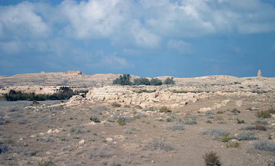
Panoramic view of the kom of Plinthine.

Interior of the east rotunda of the Greek baths at Taposiris Magna.

View of the port of Taposiris Magna with the Roman bridge in the foreground and the “Tower of the Arabs” and the temple of Osiris in the background.

The reused stele of Seti II found on the kom of Plinthine.

The Saite wine press at Plinthine.

© MFTMP/Ifao/G. Pollin.

© MFTMP/Ifao/G. Pollin.

Histoire des sites
Séparées par seulement 2,2 km à vol d’oiseau, Taposiris Magna et Plinthine font partie, à l’époque ptolémaïque (331-30 av. J.-C.), d’une multitude de bourgades localisées sur les rives du lac Maréotis, dans la région d’Alexandrie, et peuplées, en partie, de colons gréco-macédoniens arrivés sous l’impulsion d’Alexandre et ses successeurs, les Lagides. Les vestiges de surface les plus remarquables remontent à cette période et ont accaparé les premiers travaux effectués sur les sites.
Toutefois, les travaux de la Mission française de Taposiris Magna et Plinthine (MFTMP) ont démontré que l’histoire des deux villes était plus complexe. Ils connaissent un destin contraire, lié à des facteurs politiques et environnementaux : Taposiris Magna est attestée du IIIe s. av. J.-C. à la conquête arabe, décolle au IIe s. av. J.-C. et connaît un pic d’activité à l’époque romano-byzantine ; Plinthine est occupée depuis au moins le Nouvel Empire, s’épanouit à l’époque saïto-perse (milieu du VIIe s.-début du Ve s. av. J.-C.) puis à l’époque hellénistique (331-30 av. J.-C.), avant de disparaître au Ier s. apr. J.-C.
Historiographie
Le site d’Abousir est identifié dès le XIXe s. à la Taposiris Magna des sources anciennes (Strabon, Ptolémée, etc.). Le site voisin de Kôm el-Nogous est quant à lui assimilé à la localité de Plinthine, que mentionne indirectement Hérodote, en raison de leur proximité géographique. Mais il faut reconnaître que cette identification n’est pour le moment qu’une hypothèse, contrairement à celle d’Abousir avec Taposiris Magna, qui a été confirmée par la découverte in situ d’inscriptions et ostraca portant la mention du toponyme ancien.
Au début du XIXe s., Abousir et Kôm el-Nogous ont été visités par les savants de l’expédition d’Égypte, qui en ont laissé de précieuses descriptions et relevés. Les premières fouilles furent ensuite réalisées par deux directeurs du Musée gréco-romain d’Alexandrie, Evaristo Breccia et Achille Adriani, qui ont exploré les vestiges les plus remarquables des deux sites dont ils avaient compris l’intérêt : temple ptolémaïque dédié à Osiris, « tour des Arabes » (en réalité un monument funéraire érigé au cours de l’époque hellénistique, qui imite la forme du phare d’Alexandrie) et terrasse Breccia (bains, nécropole d’animaux momifiés, chapelle) à Taposiris Magna, nécropole et ville hellénistiques de Plinthine. Le service des Antiquités a engagé dans la seconde moitié du XXe s. des travaux de restauration du temple, et des opérations de fouille furent conduites dans les années 1980, sans publication, dans la nécropole de Plinthine.
Travaux de la Mission française de Taposiris Magna et Plinthine (MFTMP)
Depuis 1998, la MFTMP, fondée et dirigée par Marie-Françoise Boussac jusqu’en 2018, a repris l’étude de ces deux sites et de leur environnement. C’est pour mieux comprendre leur rôle au fil du temps et le phénomène de bascule entre Plinthine et Taposiris Magna, et plus largement pour reconstituer l’histoire de la zone nord-ouest de la Maréotide, que leur exploration s’est toujours faite en parallèle.
La MFTMP a commencé ses travaux en se concentrant sur les vestiges gréco-romains des deux bourgades, dans la droite ligne des explorations précédentes : l’équipe française a ainsi exploré la zone portuaire de Taposiris Magna, constamment réaménagée du début de l’époque romaine à la fin de l’époque byzantine, qui fait de la ville un verrou fiscal et sans doute administratif à l’ouest d’Alexandrie. Nos travaux ont aussi concerné la terrasse Breccia située en contrebas du temple d’Osiris, avec la fouille des bains grecs les mieux conservés du monde, à proximité d’une petite nécropole d’animaux momifiés, révélant ici la juxtaposition de pratiques culturelles si caractéristiques de l’Égypte ptolémaïque (bain collectif à la grecque, culte égyptien aux animaux sacrés). À Plinthine, c’est la nécropole hellénistique qui a été l’objet de notre attention ; son exploration a permis d’illustrer l’évolution des pratiques funéraires d’une petite communauté grecque installée dans la chôra égyptienne sur plus de trois siècles.
Depuis 2012, la MFTMP s’efforce de déterminer la nature des occupations les plus anciennes du site de Plinthine, dont la découverte a été une surprise : rien en effet ne laissait supposer (sauf les témoignages peu clairs d’Hellanicos et Hérodote) que le site remontait à la période pré-ptolémaïque. En lançant la fouille du Kôm el-Nogous, imposant kôm en forme de fer-à-cheval de plus de 11 m de haut, qui domine au nord la ville hellénistique, nos travaux ont révélé l’importance, dès le Nouvel Empire, de la bande côtière de la Maréotide que l’on croyait oubliée par les pharaons et investie seulement par les Lagides. De fait, Plinthine a livré sur son territoire des traces d’occupation des XVIIIe et XIXe dynasties dont une stèle dédiée par Séthi II et des blocs portant le cartouche de Ramsès II. La présence royale se manifeste encore sous la XXVIe dynastie (664-525 av. J.-C.), par la découverte d’un cartouche de Néchao II sur le site, où se développe un habitat prospère, dont la vitalité est liée à la viticulture.
À l’autre extrémité du spectre chronologique, nos travaux récents sur les thermes romano-byzantins de Taposiris Magna et sur des entrepôts tardifs de la zone portuaire ont mis en lumière la vigueur des échanges en Maréotide aux Ve-VIIe s. Ils ont révélé l’impact du nouveau rôle de porte occidentale de l’Égypte joué par Taposiris Magna depuis le Haut-Empire au moins et les conséquences de l’invasion arabe au VIIe s. sur la ville : elle semble encore occupée et les thermes sont refaits et toujours en utilisation au moins jusqu’au VIIIe s. Contrairement à ce que l’on pensait jusqu’alors, la conquête arabe n’a pas signifié la fin abrupte de l’occupation de Taposiris Magna, dont l’abandon est intervenu plusieurs décennies après.
Bérangère Redon (CNRS, UMR 5189)
History of the sites
Separated by only 2.2 km as the crow flies, Taposiris Magna and Plinthine are among numerous villages located on the banks of Lake Mareotis in the region of Alexandria, during the Ptolemaic period (331-30 BC). They were partly inhabited by colonies of Greek-Macedonians who arrived through the encouragement of Alexander and his successors, the Lagides. The most remarkable surface remains date to this period and became the focus of the first investigations undertaken at the site.
However, the work of the Mission française de Taposiris Magna et Plinthine (MFTMP) has demonstrated that the history of the two towns was complex. They experienced a differing destiny which was linked to political and environment factors: Taposiris Magna is attested from the 3rd century BC until the Arab Conquest, with a peak of activity in the Romano-Byzantine period; Plinthine, which was occupied at least from the New Kingdom, continued on through the Saite-Persian period (the middle of the 7th century to beginning of the 5th century BC), then into the Hellenistic period (331-30 BC), before disappearing in the 1st century AD.
Historiography
From the 19th century the site of Abusir was identified as the town of Taposiris Magna evoked by ancient sources (e.g. Strabo, Ptolemy etc.). The neighbouring site of Kom el-Nogus is thought to be the Plinthine mentioned indirectly by Herodotus, due to its proximity to Taposiris Magna. But admittedly, this identification is currently only a hypothesis, unlike the correlation of Abusir with Taposiris Magna which has been confirmed by the discovery of inscriptions and ostraca in situ which mention the ancient toponym.
At the beginning of the 19th century, Abusir and Kom el-Nogus were visited by scholars of the Expedition of Egypt who brought away from there valuable descriptions and recordings. The first excavations were then conducted by Evaristo Breccia and Achille Adriani, two directors of the Graeco-Roman Museum in Alexandria, in the early 20th century. At the two sites, they explored the most remarkable remains which took their interest. At Taposiris Magna that consisted of the Ptolemaic temple dedicated to Osiris, the Tower of the Arabs (in fact a funerary monument erected during the Hellenistic period which imitated the shape of the Lighthouse of Alexandria); baths, mummified animal necropolis and a chapel on the Breccia Terrace. At Plinthine it was the Hellenistic necropolis and town. In the second half of the 20th century, the Antiquities Service undertook restoration work at the temple, and in the 1980s they conducted excavation activities in the necropolis of Plinthine, as yet unpublished.
Work of the Mission française de Taposiris Magna et Plinthine (MFTMP)
Since 1998, the MFTMP, which was founded and directed by Marie‑Françoise Boussac until 2018, resumed the study of these two sites and their environmental context. Investigation of these two sites is always conducted in tandem so as to understand better their role over time with the seesawing phenomenon between Plinthine and Taposiris Magna and to reconstruct in broader terms the history of the north-west zone of the Mareotis area.
The MFTMP began its work by focussing on the Graeco-Roman remains of the two villages, continuing the previous lines of investigation. The French team thus explored Taposiris Magna’s harbour area, which was constantly redeveloped from the beginning of the Roman to the end of the Byzantine period, and which made the town of fiscal, and undoubtedly administrative, significance in the area west of Alexandria. Our work also focused on the Breccia Terrace situated below the temple of Osiris, excavating the best-preserved Greek baths in the world in the vicinity of a small necropolis of mummified animals, thus revealing a juxtaposition of cultural practices so characteristic of Ptolemaic Egypt (Greek collective baths and the Egyptian cult to sacred animals). At Plinthine it is the Hellenistic necropolis which has been the subject of our attention. Its exploration has enabled us to determine the evolution over more than three centuries of funerary practices of a small Greek community settled in the Egyptian chôra.
Since 2012, the MFTMP has shifted its focus and is questioning the nature of the most ancient occupation of the site of Plinthine (whose discovery had been a surprise). Indeed, nothing had led us to believe (apart from obscure mentions by Hellanicos and Herodotus) that the site had existed in the pre-Ptolemaic period. While excavating Kom el-Nogus, an imposing horseshoe-shaped mound more than 11 m high which rises to the north of the Hellenistic town, our work revealed the importance of the Mareotis coastal strip from New Kingdom times. The belief had been that this location was ignored by the pharaohs and only of interest to the Lagides. In fact, over the site of Plinthine traces dating back to the 18th and 19th Dynasties were revealed, including a stela dedicated by Seti II and blocks bearing the cartouche of Ramesses II. A royal presence at the site appears again, this time dating to the 26th Dynasty (664-525 BC), with the discovery of a cartouche of Necho II, when the settlement prospered through activities linked to viticulture.
At the other end of the chronological spectrum, our recent work on the Romano-Byzantine baths at Taposiris Magna and its Late Antique warehouses in the harbour area have shed light on the dynamism of commerce in Mareotis from the 5th to 7th centuries AD. It has revealed the impact of the new role played by Taposiris Magna as a western harbour of Egypt from at least the Early Roman period and the consequences on the city of the Arab invasion in the 7th century. Apparently, it continues to be occupied and the baths are refurbished and constantly in use at least until the 8th century. Contrary to what was previously thought, the Arab Conquest did not signify an abrupt end to the occupation at Taposiris Magna, whose abandonment took place several decades later.
Bérangère Redon (CNRS, UMR 5189)
تاريخ الموقعيْن
تُقدَّر أقصر مسافة بين تاپوزيريس ماجنا وپلانتين بـ 2,2 كم فقط. وهما من القرى التي كانت منتشرة على بحيرة مريوط خلال العصر البطلميّ (331-30 ق. م.)، وكان من بين سكانهما مستوطنون يونانيون-مقدونيون قَدِموا إلى تلك المنطقة بتشجيعٍ من الإسكندر ومن جاء بعده من الحكام البطالمة. لذا؛ فإن أبرز البقايا الأثريَّة تعود إلى هذا العصر، وهي التي تناولتها الحفائر الأولى في الموقعيْن.
وقد برهنت الحفائر التي أجرتها البعثةُ الأثريّةُ الفرنسيَّة في مدينتيّْ تاپوزيريس ماجنا وپلانتين، على أن تاريخ الموقعيْن أكثر تعقيداً من المتوقع، فقد شهدتا مصيرًا معاكسًا في القدَم كنتيجة لعدة عوامل سياسية وبيئيَّة. فشهدت تاپوزيريس ماجنا، منذ القرن الثالث ق. م. وحتى الفتح العربي، انطلاقًا ملحوظًا خلال القرن الثاني ق. م. ووصلت إلى قمَّة نشاطها في العصر الرومانيّ-البيزنطيّ. بينما تم إشغال قرية پلانتين منذ بداية عصر الدولة الحديثة على أقل تقدير، وازدهرت في العصر الصاويّ-الفارسيّ (الذي يمتدُّ من منتصف القرن السابع وحتى بداية القرن الخامس ق. م.)، ثم الحقبة الهِلِّينستيَّة (331-30 ق. م.)، ذلك قبل أن تندثر في القرن الأول الميلاديّ.
نتاج التأريخ
في القرن التاسع عشر، تم تحديد موقع «أبو صير» على أنه تاپوزيريس ماجنا التي ورد ذكرها في المصادر القديمة (عند سترابون، وبطليموس، وغيرهما)، وتأكَّدت هذه الفرضية مرات عدة بفضل اكتشاف نقوش وشقفات في الموقع تحمل اسمه القديم، ذلك بخلاف قرية كوم النجوس التي، نظرًا لقربها من موقع تاپوزيريس، تم تحديدها أنها مدينة پلانتين القديمة (التي ذُكرت بشكل غير مباشر بدءًا من هيرودوت). وعلينا أن نعترف أن هذا التعريف لا يزالُ مجرد فرضية.
وفي بداية القرن التاسع عشر، زار علماءُ الحملة الفرنسيَّة مدينتيّْ «أبو صير» وكوم النجوس، وقاموا بعدة عمليات رفع وقدموا وصفًا قيِّمًا عنهما. ثم تمت أول عمليَّات تنقيب في الموقعيْن على يد اثنين من مُديري المُتْحَف اليوناني-الرومانيّ بالإسكندرية، وهما، إيڤارستو بريشيا، وأشيل أدرياني، واللذان اكتشفا أهم البقايا الأثريَّة بالموقعيْن، وذلك بعد أن أدركا أهميتهما: معبد بطلمىّ مُخصَّص لأوزيريس، و«برج العرب» (وهو في الحقيقة مبنًى جنائزيّ شُيِّد خلال العصر الهِلِّينستيّ يحاكي فنار الإسكندرية)، ومنطقة بريشيا والتي تضمُّ حمَّامات، وجبَّانة حيوانات مُحنَّطة، وكنيسة صغيرة. وفي تاپوزيريس ماجنا، عُثِر على جبانة ومدينة هِلِّينستيَّة قديمة. ثم قامت هيئة الآثار، خلال النصف الثاني من القرن العشرين، بأعمال ترميم في المعبد. كما أجرت أعمال تنقيب في جبَّانة پلانتين في ثمانينيَّات القرن الماضي، ولكن دون نشر نتائج هذه الأبحاث.
أعمال البَعْثة الفرنسيَّة في موقعَيّ تاپوزيريس ماجنا وپلانتين (MFTMP)
منذ عام 1998، استأنفت البعثةُ الأثريَّةُ الفرنسيَّةُ (MFTMP) برئاسة ماري فرانسواز بوساك - مُؤسِّسة البعثة والتي ترأَّستها حتى عام 2018 - دراسة الموقعيْن والبيئة المحيطة بهما. فكان التنقيب في هذين الموقعيْن يتم على نحوٍ مُتوازٍ بُغية التوصل إلى فهمٍ أفضل لدوريهما على مر العصور، ولظاهرة التبادلية بين تاپوزيريس ماجنا وپلانتين. وبصورة أوسع كانت البعثةُ تهدفُ إلى التوصل للصياغة الكاملة لتاريخ منطقة شمال غرب بحيرة مريوط.
بدأت البعثةُ الأثريَّةُ أعمالها بالتركيز على البقايا الأثريّة من العصر اليونانيّ-الرومانيّ، سائرةً على نهج عمليَّات الاسكتشاف السابقة: فقامت البعثة باستكشاف منطقة ميناء تاپوزيريس، والتي شهدت تحديثات دائمة طوال الفترة الممتدة من بداية العصر الرومانيّ وحتى نهاية العصر البيزنطيّ، وهو ما جعل ذلك الميناء-المدينة بمثابة واحة ضريبيَّة وإداريَّة، غرب مدينة الإسكندريَّة. كما شملت أعمال التنقيب منطقة بريشيا الواقعة أسفل معبد أوزيريس؛ حيث أجرت البعثة عمليَّةَ تنقيبٍ في الحمَّامات اليونانيَّة والتي تُعدُّ الحمامات اليونانية الأفضل حِفظاً على مستوى العالم، وتقع على مقربة من جبَّانة صغيرة للحيوانات المُحنَّطة؛ مما يُنْبئ بتجاور الممارسات الثقافية المختلفة التي كانت تتَّسم بها مصر خلال العصر البطلميَّ (حمَّام جماعيّ على الطراز اليوناني، وإحدى العقائد المصرية القديمة الخاصة بالحيوانات المقدسة). وفيما يتعلق بپلانتين، كانت الجبَّانة الهِلِّينستيَّة هي محل اهتمامنا، وقد ساعد استكشافها على توضيح التطورات التي مرَّت بها الشعائر الجنائزية، لجالية يونانيَّة صغيرة استوطنت إحدى الضواحي المصريَّة لمدة تناهز الثلاثة قرون.
منذ عام 2012، سعت البعثة الأثريّة الفرنسية العاملة في تاپوزيريس ماجنا وپلانتين لتحديد طبيعة الإشغال في موقع پلانتين الأكثر قِدَمًا (أي البقايا الأثريّة بدءًا من عصر الرعامسة وحتى العصر الصاوي) والتي كان اكتشافها أمرًا مدهشًا. فباستثناء الشهادات غير الواضحة التي تركها هيلانيكوس وهيرودوت، لم يكن هناك أيُّ دليلٍ على أن هذا الموقع يعود إلى عصور ما قبل عصر البطالمة. لكن مع بدء عمليات التنقيب بكوم النجوس - وهو كومٌ مَهِيبٌ يأخذ شكل حدوة فرس يصل ارتفاعُه إلى أكثر من 11م، يطلُّ على شمال المدينة الهلِّينستيَّة - تكشَّفت أهمية الشريط الساحلىّ لبحيرة مريوط منذ بداية الدولة الحديثة، والتي كنا نعتقد أنها لم تكن محلَّ اهتمامٍ في العصر الفرعوني، وأنه لم يبدأ ارتيادها إلا في العصر البطلمي. وكشفت لنا أرض پلانتين عن آثار إشغال من عصر الأسرتين الثامنة عشرة، والتاسعة عشرة؛ حيث عُثر على لوحٍ حجريٍّ قام بإهدائه الملك سيتي الثاني؛ وكذلك كتل تحمل خرطوش الملك رمسيس الثاني. وكان اكتشافُ خرطوش للملك نخاو الثاني في هذا الموقع - الذي كان موقعًا سكنيًّا مزدهرًا ارتبطت حيويته بزراعة الكروم - دليلًا على التواجد المَلَكيّ في تلك المنطقة في ظِلِّ حكم الأسرة السادسة والعشرين (664 ق. م. وحتى عام 525 ق. م.).
أما أحدثُ أعمالنا، فقد كان التنقيب في الحمَّامات الحراريَّة الرومانيَّة-اليونانيَّة بتاپوزيريس ماجنا؛ وكذلك المخازن التي تعود إلى عصور متأخرة في منطقة الميناء. وهو ما كشف عن حيوية النشاط التجاري في منطقة الميناء المحيطة ببحيرة مريوط، خلال القرنين الخامس والسادس الميلاديين. كما كشف عن أهمية الدور الجديد الذي لعبته تاپوزيريس ماجنا كبوابة غربية لمصر منذ عصر الإمبراطوريَّة الرومانيَّة على أقل تقدير، وأثر الفتح العربي في القرن السابع الميلاديّ: هذا الموقع يبدو أنه ظلَّ مسكونًا، كما تم تجديد الحمَّامات التي ظلت مُستخدمةً حتى القرن الثامن على أقل تقدير. وخلافًا للاعتقاد الذي كان سائدًا، لم يعنِ الفتحُ العربيُّ الإنهاء المفاجئ لتواجد السكان في تاپوزيريس، فلم تُهجَر المنطقة إلَّا بعد ذلك بعدة عقود.
بيرانجير رودون (المركز الوطنيّ للبحث العلميّ - UMR 5189)
Bibliographie
- M.-F. Boussac, M. El-Amouri, « The lake structures at Taposiris », in L. Blue, E. Khalil (éd.), Lake Mareotis Conference: reconstructing the past, Universities of Southampton and Alexandria, 5th-6th April 2008, BAR-IS 2113, Oxford, 2010, p. 87-105.
- M.-F. Boussac, « Recent works at Taposiris and Plinthine », BSAA 49, 2015, p. 189-217.
- M.-F. Boussac, S. Dhennin, B. Redon (avec une annexe de Z. Barahona-Mendieta), « Plinthine et la Maréotide pharaonique », BIFAO 115, 2015, p. 15-35, https://www.ifao.egnet.net/bifao/115/02/.
- B. Redon, M. Vanpeene (avec une annexe céramologique de M. Pesenti), « “La vigne a été inventée dans la ville égyptienne de Plinthine”. À propos de la découverte d’un fouloir saïte à Kôm el-Nogous (Maréotide) », BIFAO 116, 2016, p. 303-324, https://www.ifao.egnet.net/bifao/116/12/.
- T. Fournet, B. Redon, « Bathing in the shadow of the pyramids. The Greek baths in Egypt, an original bathing model », in B. Redon (éd.), Collective baths in Egypt 2. New discoveries and perspectives, EtudUrb 10, Le Caire, 2017, p. 99-137.
- Page web Taposiris Magna et Plinthine archivée (2015)