Citadelle du Caire

Walls of the Salah al-Din al-Ayyubi Citadel: Southern and northern external borders
Excavation and study Project
Dr. Muḥammad Ibrāhīm ʿAbd al-ʿĀl (Faculty of Archaeology Ain Šams University)
Dr. Joachim Le Bomin (French Archaeological Institute IFAO)
Introduction
In 2023, as part of the development of the Cairo citadel built under the Ayyubid period, several neighbourhoods located around the wall have been relocated by the Egyptian government. This concerns in particular two areas :
- The southern external enclosure (area 1) where the aqueduct probably ends with a wheel tower attributed to Nasir Mohammed bin Qalawon (No. 369 in the Arab al-Yassār)
- the northern external enclosure where the Khanga al-Nizāmiyah Mosque of the seven sultans (Mamluk period) is located.
Transformed into an open area, these grounds offer the unique opportunity to study a part of the exterior of the citadel enclosure, the associated developments (its link with the outlet of the aqueduct) as well as the possible occupations of the adjacent districts, especially during the Ayyubid and Mamluk eras. Indeed, no excavation has ever been carried out and many important questions remain unanswered.
The Cairo Citadel
|
Figure 2: Layout of the Citadel today (Public Domain) |
The Cairo Citadel was a huge fortified complex and royal residence (Qal’at al-Jabal) initiated by Salāḥ al-Din al-Ayyūbī between 1176 and 1183 AD, and likely ended entirely at the beginning of the 13th c. AD by the sultan al-Kamil (1218-1238 AD) . It was a part of vast program of fortifications participating in the defence of the capital during a period of conflicts with Crusaders. Installed on a rocky spur (Muqattam), outside the urbanized area, which dominates the environment over nearly 10 ha, it plays the role of a lock integrated into the enclosure of about 12 km with nearly 80 towers, whose objective was to unite the ancient city of Misr-Fûstat with the caliphal city of al-Qâhira and its enclosure of 2250 m side built by the Fatimid at the end of the 10th c., then rebuilt in stone between 1087 and 1092 AD . Beyond the military aspect, the Citadel aims to symbolically strengthen the new Ayubbid power over these Fatimid predecessors. Subsequently, the major military architectural works of the Mamluks and Ottomans were solely focused on the Citadel, the seat of the power and the main organ of defence of the city. It was mainly during the Ottoman period that the citadel underwent numerous modifications and renovations with the construction of the Muqattam tower and the reconstruction of external walls.
Among the buildings which participate in the functioning of the Citadel is an aqueduct built during the Ayyubid period under Sala ad-Din and his successors but was removed and improved under the Mamluks by the sultan al-Nasir Muhammad in the beginning of the 14th c. Linked to the Nile, it started from the wall's western end near Fustat (at the shore of the Nile), where water was raised through a series of waterwheels (saqyia), and run from there to the Citadel. The famed spiral well inside the citadel constructed by Salaḥ al-Dīn (also known as Bīr Yusuf), which may supply water in times of siege if the canal is shut off, was erected in addition to his canal system.
1. Study areas
1.1. Area 1: the southern wall
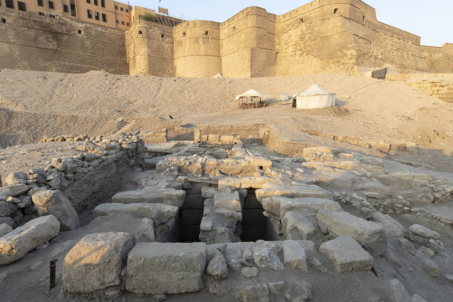
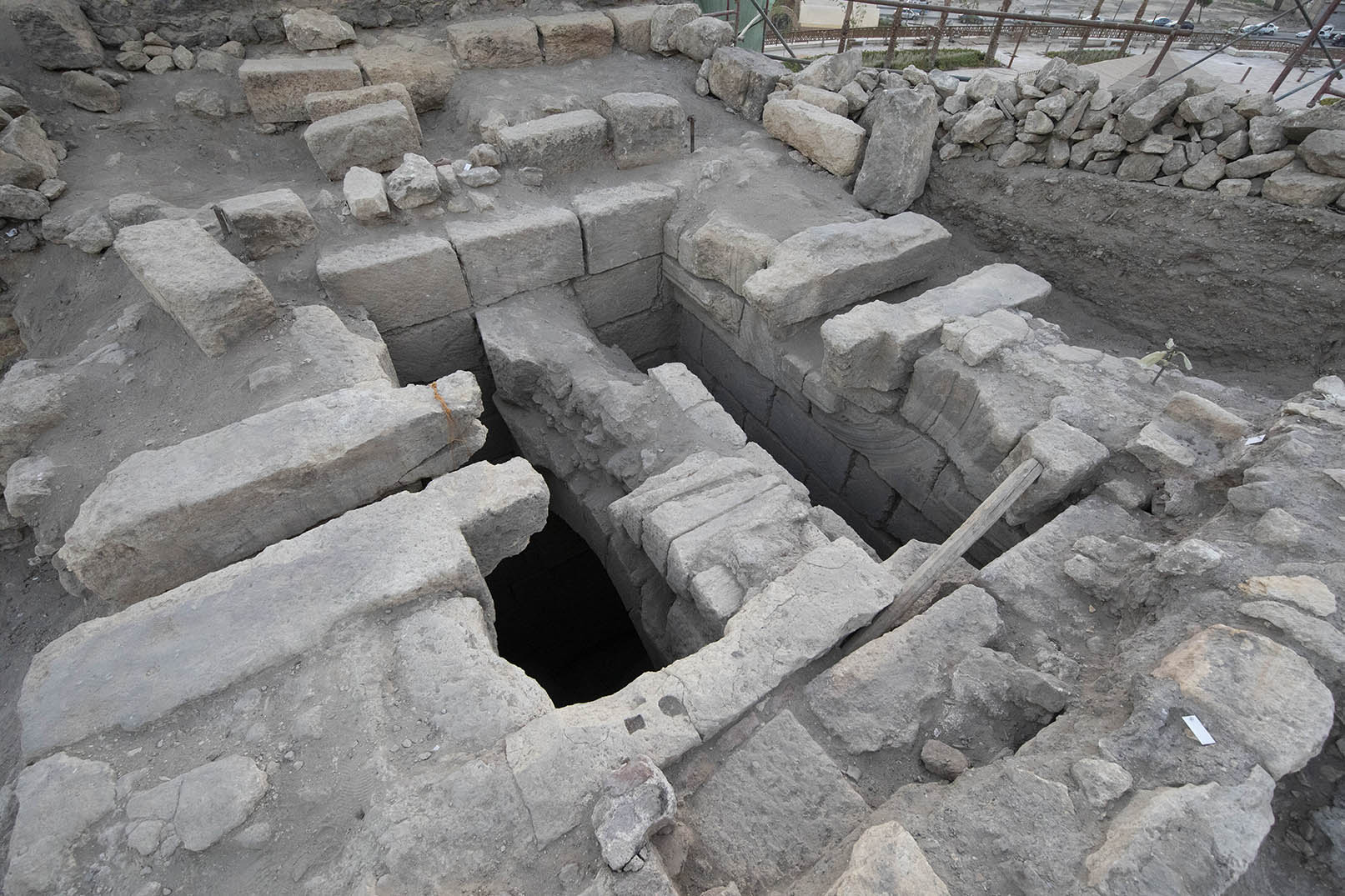
The area 1 is located to the southern part, outside of the Citadel covers an area of approximately 8200 m² along the south wall for about 160 m long and 60 m wide to the south. This demarcated area includes in its southwest part a wheel tower, which is credited to the Sultan Nāṣir Muḥammad bin Qalāwūn in 712AH/1312AD. It belongs to the outer perimeter of the fortifications and is probably located at the outlet of the aqueduct.
The objective of the investigations is to study the exterior part of the enclosure, to highlight the final water supply system for the Citadel from the aqueduct with the last wheel tower outside de fortification and to manage the restoration of the associated buildings.
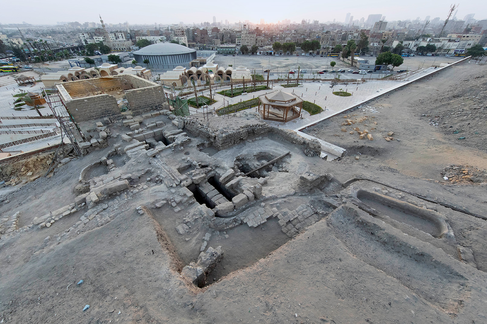
1.2. Area 2: sector of the northern wall
The second area is located at the north-eastern part outside of the wall of the Citadel and covers and an area of about77000m². The sector, which offers a unique panorama of the region is bounded by the Al-Hatabah district. This portion of the fortress is marked by the presence of, and advanced bastion flanked by two towers (Burj al-Ramla and Burj al-Hadid) probably belonging to Salāḥ al-Din’s architectural program and reinforced by al-Kalim. In this area, one of the most significant Mamluk structures is the Khanka al-Nizāmiyah Mosque. Al-Khanqah al-Nizamiya is the name of the Khankah that Bahari Mamluk prince Nizām al-Din built in 757 AH[1]. This khankah is situated in the Hatabah suburb, which extends to Salah al-Din's citadel on the northern side. This Khanqah is located precisely in the high place on the level of the Bab al-Wazir area at the summit of al-Nushuz. The Khanqah al-Nizamiyah was erected next to the citadel at Al-Hutaba, and because of the military and political events that took place there, the region was looted and destroyed. Most of these incidents occurred under Mamluk and Ottoman rule. The events in the area included demolition, destruction, change of milestones from the Franks, including the demolition of the minaret of the Khanqah al-Nizamiyah and making it a defensive fortress.
The remnants of Cairo's eastern wall, one of its lost and previously unrevealed sections, are also present here and connected to the fences of Qal 'at al-Jabal. Al-Turabi mosque, which belongs to the Mamluk era, also has remains. There are also traces of further architectural structures, some of which may be Mamluk in origin. The Sariya al-Gabal mosque receives water from this enormous well. To find the monuments and installations connected to the citadel from this side, a sizable area needs to be explored.
- Archaeological and study project
The archaeological and study project is a cooperation and co-direction between IFAO represented by Joachim Le Bomin (head of archaeological department) and Ayn Shams university (faculty of archaeology) represented by Mohamed Ibrahim. It concerns two areas located around the fortress, never having been investigated until today, essential for the historical and archaeological knowledge of medieval Cairo and of an emblematic monument. These investigations, which will be done according to the Egyptian laws and under the supervision of the MOA, will highlight the historical and architectural heritage of the Islamic period of the city. Thereafter, the site must be exploited in terms of heritage, making excellent use of it for the benefit of both specialists and the surrounding environment.
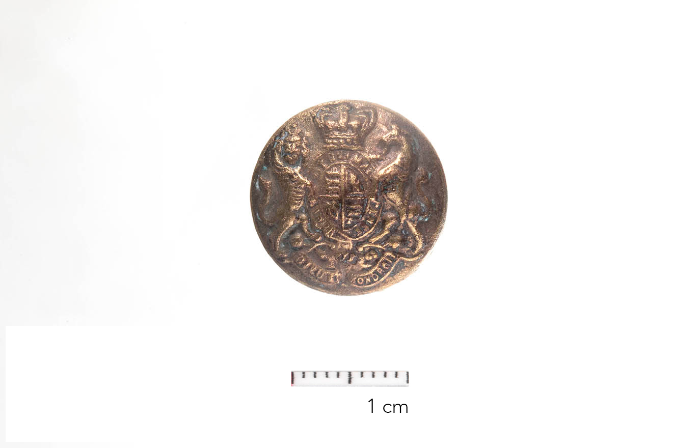
The mission began its first season in August 2024 by working in both sites. In the first site, it succeeded in uncovering several Canals that deliver water to the Citadel. Two huge towers dating back to the Mamluk period, specifically the period of Al-Nasir Muhammad bin Qalawun, were also uncovered, dedicated to preserving and storing water. Four waterwheels were uncovered, as well as the waterways dedicated to animals, which are being uncovered for the first time, as well as several water basins, walls, and remains of buildings belonging to the water system connected to the wall of the Magra Al-Ayoun, in addition to several artistic pieces dating back to different time periods. In the second site, documentation and architectural elevation of the remaining facilities were carried out, and field studies are underway in preparation for the start of excavation work in the second season.
Source of funding for the Mission
Institut français d'archéologie orientale IFAO
Preliminary teamwork
|
1 |
Dr Mohamed Ibrahim (archaeologist) |
Director of the mission Ayn Shams university |
|
2 |
Dr. Joachim Le Bomin (archaeologist) |
Co-director of the mission Head of the archaeological department IFAO |
|
3 |
Dr. Pierre Tallet |
Director of IFAO |
|
4 |
Dr. Abbès Zouache |
Director of Studies IFAO |
|
5 |
Prof. Ahmed Al.Shoky |
Ayn Shams university |
|
6 |
Ḥāmid Yūsuf |
Administrative director of the excavations |
|
7 |
Dr. Paul François (architect) |
French scientific institute (CNRS) |
|
8 |
Dr. Julie Monchamp |
Ceramologist |
|
9 |
Mohamed Gaber (topographer) |
IFAO |
|
10 |
Dr. Walid Aḥmad Ṣalāḥ al-Din al-Alaīly (archaeologist) |
Ayn Shams university |
|
11 |
Ihab Ibrahim (photographer) |
IFAO |
|
12 |
Matjaz Kacicnik (photographer) |
IFAO |
|
13 |
Dr. Anita Qiles |
Head of the archaeometry laboratory IFAO |
|
14 |
Dr. Sylvie Marchand (ceramologist) |
IFAO |
|
15 |
Dr. Simon Connor (archaeologist) |
IFAO |
|
16 |
Dr. Ashgan Ahmed(archaeologist) |
Ayn Shams university |
|
17 |
Dr.Ghada Nagy fayed(archaeologist) |
|
|
18 |
Dr.Nora Abdelkader(archaeologist) |
Ayn Shams university |
|
19 |
Dr.Rawan Ahmed Adel(archaeologist) |
Ayn Shams university |
|
20 |
Dr.Nora Mohamed Husein(archaeologist) |
Ayn Shams university |
[1] Mohamed Abu Al-Amayem, Muhammad Ali Abdel Hafeez Muhammad, New Islamic antiquities from the Hattaba area and Bab al-Wazir cemetery in Cairo, Journal of the General Union of Arab Archaeologists, vol.9, p.133-148.
أسوار قلعة صلاح الدين الأيوبي: الحدود الخارجية الجنوبية والشمالية
مشروع التنقيب والدراسة
المسئولين:
د. محمد ابراهيم عبد العال (كلية الآثار - جامعة عين شمس)
د. يواقيم لو بومين (المعهد الفرنسي للآثار IFAO)
الشركاء:
ü المعهد العلمي الفرنسي للأثار الشرقية بالقاهرة
ü كلية الاثار جامعة عين شمس
مقدمة:
في عام ٢٠٢٣، قامت الحكومة المصرية - كجزء من تطوير قلعة صلاح الدين بالقاهرة التي بنيت في العصر الأيوبي - بنقل العديد من الأحياء الواقعة حول الأسوار الخارجية من اجل اعمال الحماية والتطوير لمدينة القاهرة بشكل كامل. ويتعلق هذا المشروع على وجه الخصوص بمنطقتين
Ø السور الخارجي الجنوبي (منطقة ١) حيث تنتهي القناة المائية (سور مجري العيون) على الأرجح ببرج الساقية الذي ينسب إلى السلطان المملوكي الناصر محمد بن قلاوون (أثر رقم ٣٦٩ - عرب اليسار).
Ø السور الخارجي الشمالي حيث تقع الخانقاة النظامية ومسجد السبع سلاطين وبقايا سور صلاح الدين (الفترة المملوكية).
بعد تحويل تلك الأماكن إلى منطقة مفتوحة، توفر هذه المناطق فرصة فريدة لدراسة جزء من السياج الخارجي من القلعة والتطورات المرتبطة به (ولا سيما ارتباطها بمخرج القناة المائية) بالإضافة إلى التطورات التي تمت وخاصة في العصرين الأيوبي والمملوكي. في الواقع، لم يتم إجراء أي حفائر على الإطلاق هناك، ولا تزال العديد من الأسئلة المهمة تبقى دون إجابة ويهدف هذا المشروع إلى الإجابة وكشف اللثام عن هذه التساؤلات الهامة.
قلعة الجبل بالقاهرة:
كانت قلعة صلاح الدين بالقاهرة عبارة عن مجمع محصن ضخم ومقر إقامة ملكي (قلعة الجبل) أنشأها صلاح الدين الأيوبي بين عامي 572هـ - 604هـ/ 1176- 1207م، ومن المحتمل أن يكون انتهى العمل بها في بداية القرن السابع الهجري/ الثالث عشر الميلادي على يد السلطان الكامل (576-645هـ/ ١٢١٨-١٢٣٨م). لقد كانت جزءًا من برنامج واسع من التحصينات المشاركة في الدفاع عن مدينة القاهرة خلال فترة الصراع مع الصليبيين.
تم بناؤها على نتوء صخري (المقطم)، خارج المنطقة الحضرية، التي تهيمن عليها بمساحة تبلغ حوالي 10 هكتارات، وتلعب دور التحصين المزدوج في السياج الذي يبلغ طوله حوالي ١٢ كيلومترًا والذي يضم ما يقرب من ٨٠ برجًا، وكان الهدف الأوحد من بنائها هو ربط المدينة القديمة أي مدينة مصر الفسطاط مع مدينة الخلافة القاهرة وسورها المبني على مساحة ٢٢٥٠م على يد الفاطميين في القرن نهاية الرابع الهجري/ العاشر الميلادي، والذي أعيد بناؤه بعد ذلك بالحجر بين عامي 470هـ/ ١٠٨٧ و484هـ/ ١٠٩٢م. وبعيدًا عن الجانب العسكري، يهدف بناء القلعة بشكل رمزي إلى إبراز قوة الأيوبيين وتوضيح تفوق هؤلاء على الفاطميين. وفي وقت لاحق، تركزت الأعمال المعمارية العسكرية الرئيسية للمماليك والعثمانيين فقط على القلعة، مقر السلطة والجهاز الرئيسي للدفاع عن المدينة. وخلال الفترة العثمانية بوجه خاص، خضعت القلعة للعديد من التغيرات والتجديدات مع بناء برج المقطم وإعادة بناء الأسوار الخارجية.
ومن المباني التي تشارك في عمل القلعة قناة مائية بنيت في العصر الأيوبي في عهد صلاح الدين وخلفائه، ولكن تمت إزالتها وتحسينها في عصر المماليك على يد السلطان الناصر محمد في بداية القرن الثامن الهجري/ الرابع عشر الميلادي حيث ترتبط بنهر النيل، وتبدأ من الطرف الغربي للسور بالقرب من الفسطاط (على شاطئ النيل)، حيث ترتفع المياه من خلال سلسلة من السواقي، وتجري من هناك إلى القلعة. قام صلاح الدين بعمل البئر الحلزوني الشهير داخل القلعة (المعروف أيضًا باسم بير يوسف)، بالإضافة إلى نظام القناة، والذي قد يوفر المياه في أوقات الحصار إذا تم إغلاق القناة.
١. مناطق العمل والدراسة:
١.١. المنطقة ١: السور الجنوبي
تقع المنطقة ١ في الجزء الجنوبي، خارج اسوار القلعة وتبلغ مساحتها حوالي ٨٢٠٠ م٢ على طول الجدار الجنوبي بطول حوالي ١٦٠م وعرض ٦٠م جنوبًا. تضم هذه المنطقة المحددة في جزئها الجنوبي الغربي برج الساقية الذي ينسب إلى السلطان الناصر محمد بن قلاوون سنة ٧١٢هـ/١٣١٢م. وهو ينتمي إلى المحيط الخارجي للتحصينات ومن المحتمل أنه يقع عند مخرج سور مجري العيون.
تهدف عمليات الفحص الأولي إلى دراسة الجزء الخارجي من السور، وتسليط الضوء على نظام إمداد المياه النهائي للقلعة من سور مجري العيون مع أخر برج خارج الحصن وإدارة ترميم المباني المرتبطة التي تنتهي ببرج الساقية.
١.٢. المنطقة الثانية: قطاع الجدار الشمالي
أما المنطقة الثانية فتقع في الجزء الشمالي الشرقي خارج سور القلعة وتبلغ مساحتها حوالي ٣٥٠٠٠م٢. وتحد منطقة الحطابة ذلك القطاع الذي يقدم بانوراما فريدة للمنطقة. يتميز هذا الجزء من القلعة بوجود حصن متقدم يحيط به برجان (برج الرملة وبرج الحداد) ربما ينتميان إلى برنامج صلاح الدين المعماري لتحصين مدينة القاهرة. ومن أهم المباني المملوكية في هذه المنطقة مبني الخانقاة النظامية. الخانقاة النظامية هو اسم الخانقاة التي بناها الأمير المملوكي نظام الدين سنة ٧٥٧هـ. وتقع هذه الخانقاة في ضاحية منطقة الحطابة، وتمتد إلى قلعة صلاح الدين من الجهة الشمالية. وتقع هذه الخانقاة تحديدًا في مكان مرتفع عن مستوى منطقة باب الوزير في قمة الهضبة الصخرية المرتفعة. أقيمت الخانقاة النظامية بجوار القلعة في منطقة الحطابة، وبسبب الأحداث العسكرية والسياسية التي جرت هناك تعرضت المنطقة للنهب والتدمير. ووقعت غالبية هذه الأحداث في ظل الحكم المملوكي والعثماني. وشملت الأحداث التي شهدتها المنطقة هدم وتخريب وتغيير معالم من قِبل الاحتلال الفرنسي، ومن بينها هدم منارة الخانقاة النظامية وتحويلها إلى حصن دفاعي.
كما توجد بالمنطقة بقايا سور القاهرة الشرقي، أحد أقسامها المفقودة والتي لم يتم الكشف عنها سابقًا، وهي متصلة بأسوار قلعة الجبل. كما توجد بقايا لمسجد الترابي الذي يعود إلى العصر المملوكي. توجد أيضًا آثار لبقايا معمارية أخرى، قد يكون بعضها مملوكيًا في الأصل. كذلك هناك بئر ضخم يقوم بإمداد الماء إلى مسجد سارية الجبل داخل القلعة. ومن أجل اكتشاف تلك الآثار والمنشآت المرتبطة بالقلعة من هذا الجانب، يجب استكشاف مساحة كبيرة منها والقيام بعمل حفائر علمية.
- المشروع الأثري والدراسي:
المشروع الأثري والدراسي هو تعاون وإدارة مشتركة بين المعهد الفرنسي للآثار الشرقية بالقاهرة ممثلًا في الدكتور يواقيم لوبومين (رئيس قسم الآثار) وجامعة عين شمس (كلية الآثار) ممثلة في الدكتور محمد إبراهيم. يتعلق الأمر بمنطقتين تقعان خارج أسوار القلعة، لم يتم عمل أية حفائر فيهما مطلقًا حتى اليوم. وهو أمر أساسي لدراسة القاهرة التاريخية والأثرية في العصور الوسطى وللتعرف على هذا الأثر الذي يحمل قيمة رمزية مهمة للغاية. وستسلط هذه الحفائر، التي سيتم إجراؤها وفقًا للقوانين المصرية وتحت إشراف وزارة السياحة والآثار، الضوء على التراث التاريخي والمعماري للعصر الإسلامي للمدينة. وبعد ذلك، يجب استغلال الموقع من الناحية التراثية، والاستفادة منه بشكل مثالي بما يعود بالنفع على المتخصصين والبيئة المحيطة.
وقد بدأت البعثة موسمها الأولى في شهر أغسطس 2024 بالعمل في كلا الموقعين، وقد نجحت بالموقع الأول في الكشف عن عدد من المجاري المائية التي تقوم بتوصيل المياه الى قلعة الجيل، كذلك تم الكشف عن برجين ضخمين يعودا الى الفترة المملوكية وتحديدًا فترة الناصر محمد بن قلاوون مخصصين لحفظ المياه وتخزينها، وتم الكشف عن عدد أربعة سواقي وكذلك المدرات المخصصة للحيوانات وهي تكشف لأول مرة وكذلك عدد من احواض المياه والجدران وبقايا ابنية تابعة للنظام المائي المتصل بسور مجري العيون، إضافة الى عدد من القطع الفنية التي تعود الى فترات زمنية مختلفة.
وبالموقع الثاني تمت عمليات التوثيق والرفع المعماري للمنشآت الباقية وتجري عمليات الدراسة الميدانية تمهيدا لبدء اعمال الحفائر بالموسم الثاني.
مصدر تمويل البعثة
المعهد الفرنسي للآثار الشرقية
فريق العمل المبدئي
|
مدير البعثة |
د. محمد إبراهيم (باحث في علم الآثار) |
١ |
|
المدير المشارك للبعثة |
د. يواقيم لوبومين (باحث في علم الآثار) |
٢ |
|
مدير المعهد الفرنسي للآثار الشرقية
|
د. بيير تاليه |
٣ |
|
مدير الدراسات بالمعهد الفرنسي للآثار الشرقية |
د. عباس زواش |
٤ |
|
جامعة عين شمس |
د. أحمد الشوكي |
٥ |
|
المدير الإداري للحفائر |
حامد يوسف |
٦ |
|
المعهد العلمي الفرنسي (المركز القومي للبحث العلمي) |
د. بول فرانسوا (مهندس معماري) |
٧ |
|
باحث في علم الخزف والفخار |
د. جولي مونشون |
٨ |
|
المعهد الفرنسي للآثار الشرقية |
محمد جابر (مساح) |
٩ |
|
جامعة عين شمس |
د. وليد أحمد صلاح الدين العلايلي (باحث في علم الآثار) |
١٠ |
|
المعهد الفرنسي للآثار الشرقية |
إيهاب إبراهيم (مصور) |
١١ |
|
المعهد الفرنسي للآثار الشرقية |
ماتياس كاشيشنيك (مصور) |
١٢ |
|
رئيسة أقسام الدارسات الأركيومترية بالمعهد العلمي الفرنسي |
د. أنيتا كيلس (باحث في علم الأركيومتري) |
١٣ |
|
المعهد الفرنسي للآثار الشرقية |
د. سيلفي مارشان (باحث في علم الخزف والفخار) |
١٤ |
|
المعهد الفرنسي للآثار الشرقية |
د. سيمون كونور (باحث في علم الآثار) |
١٥ |
|
المعهد الفرنسي للآثار الشرقية |
د. فالنتينا جسبريني (باحث في علم الخزف والفخار) |
١٦ |
|
جامعة عين شمس |
أشجان أحمد (باحث في علم الآثار) |
١٧ |
|
جامعة عين شمس |
غادة عبد السلام ناجى فايد (باحث في علم الآثار) |
١٨ |
|
جامعة عين شمس |
نورا عبد القادر (باحث في علم الآثار) |
١٩ |
|
جامعة عين شمس |
روان أحمد عادل (باحث في علم الآثار) |
٢٠ |
|
جامعة عين شمس |
نورا محمد حسين (باحث في علم الآثار) |
٢١ |
|
المعهد الفرنسي للآثار الشرقية |
نيقولا سوشون (أخصائي بيانات) |
22 |