Tabbet el-Guech
| 10.34816/ifao.65c0-ea47 | |
| 197675832 | |
| Missions Ifao depuis | 2000 |
© Ifao/O. Onézime/V. Dobrev.
General view of the Saqqara plateau, seen from the south (2003).
© S. Compoint.
© Ifao/G. Pollin.
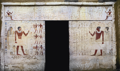
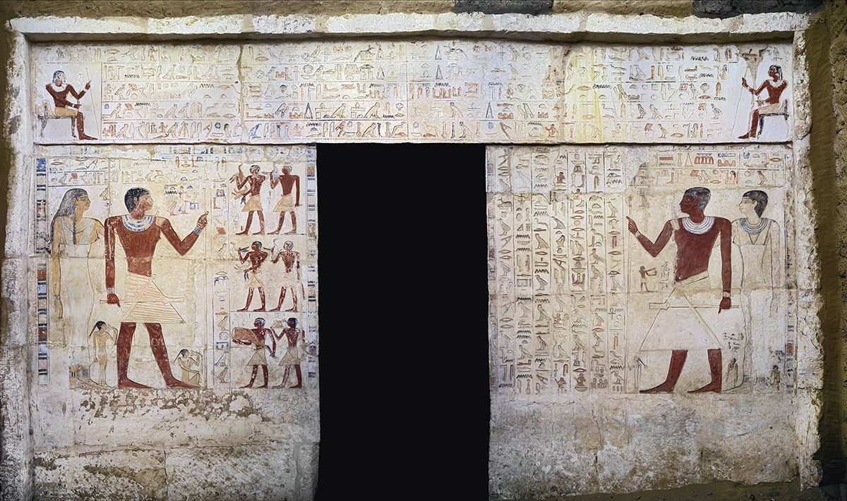
Decorated façade of the lector priest Hau-nefer shown with his wife Khuti and children.
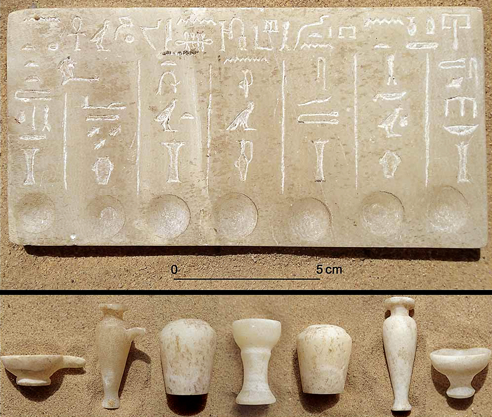
Set of funerary objects belonging to the lector priest Ankhti.
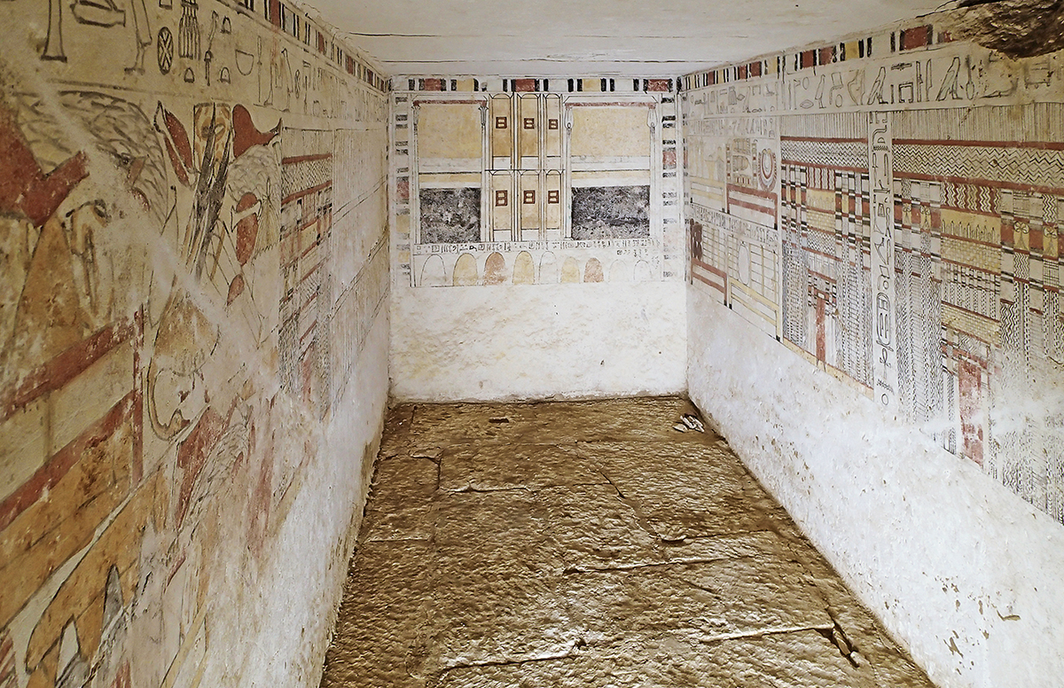
Burial chamber of the lector priest Ankhti (6th Dynasty, reign of Pepy II).
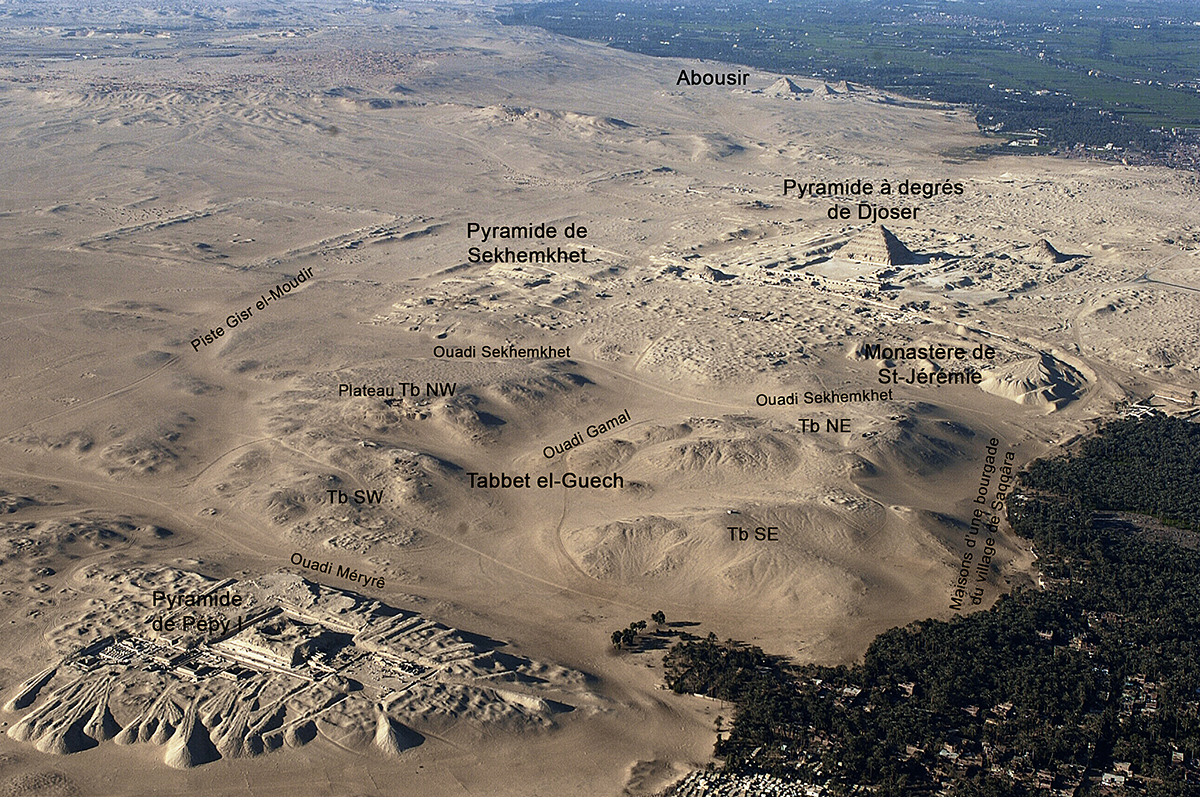
Le site est délimité au nord par le Ouadi Sekhemkhet, derrière lequel sont localisés deux grands complexes : les vestiges de la pyramide à degrés du roi Sekhemkhet (IIIe dynastie) et ceux du monastère copte de Saint-Jérémie. Au sud, c’est le Ouadi Méryrê, derrière lequel se trouve la pyramide du roi Pépy Ier (VIe dynastie) avec la nécropole des particuliers qui l’accompagne. À l’est, le site est cerné par quelques maisons de l’une des bourgades nord du village moderne de Saqqara, tandis qu’à l’ouest passe une large piste du désert appelée en arabe Gisr el-Moudir (« le grand passage »).
Tabbet el-Guech – en abrégé « Tb » – est naturellement divisé en deux grandes parties (est et ouest) par le Ouadi Gamal qui court du nord vers le sud et qui atteint presque 300 m dans les zones les plus larges. De leur côté, les parties est et ouest sont aussi divisées en deux, ce qui fait quatre entités géographiques bien distinctes : à l’est, la colline Tb NE qui occupe le quart nord-est du site et le kôm Tb SE (quart sud-est), à l’ouest, le kôm Tb SW (quart sud-ouest) et le plateau Tb NW qui s’étale sur le quart nord-ouest. La colline Tb NE a donné le nom du site en arabe : Tabbet el-Guech « la colline de l’armée ». Dans les années 1960 et 1970, l’armée égyptienne a installé un poste d’observation et de défense sur cette colline, la plus proéminente du site, s’élevant à quelque 60 m du niveau de la mer. Aujourd’hui, on peut y voir encore trois bunkers, des tranchées et des barbelés métalliques. Cette zone militaire a été abandonnée par l’armée au début des années 1980.
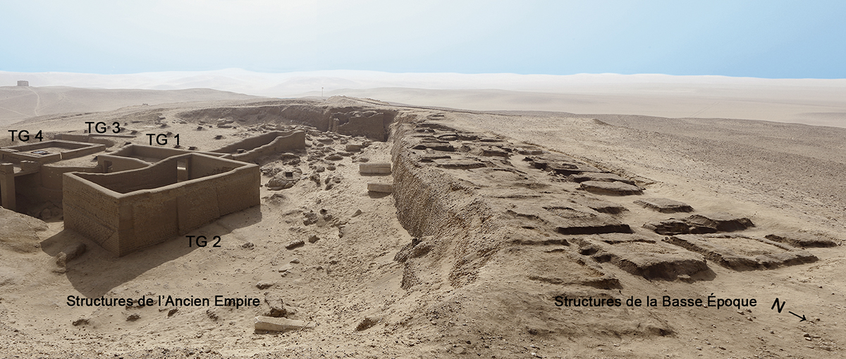
Sur le plateau Tb NW, la mission de l’Institut français d’archéologie orientale (Ifao) à Saqqara-sud a effectué, entre le 8 et le 18 octobre 2000, cinq sondages, puis, à partir d’octobre 2001, des fouilles sur une zone de 60 m sur 50 m, ce qui correspond à 2 % de la surface totale du plateau (15 ha). Même si la zone fouillée est très limitée par rapport à l’ensemble du plateau, la mission de l’Ifao a mis au jour plus de 80 structures en brique crue de tailles différentes, qui font partie d’une vaste nécropole dont l’existence n’était pas soupçonnée à cet endroit.
Les structures découvertes sur le plateau Tb NW sont des tombeaux de prêtres construits en briques crues. Ils datent principalement de la fin de l’Ancien Empire (VIe dynastie), de la Première Période intermédiaire (VIIe et VIIIe dynasties) et du début de la Basse Époque (XXVIe et XXVIIe dynasties). Même si aucune tombe des Moyen et Nouvel Empires n’a été identifiée sur Tb NW, rien n’empêche qu’il puisse y en avoir ailleurs sur le plateau, compte tenu de la surface fouillée très limitée par rapport à l’étendue totale du plateau.
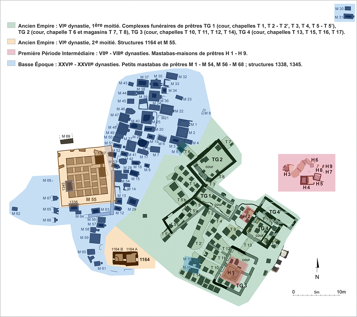
Les tombes de la première moitié de la VIe dynastie (en vert sur le plan), qui sont des complexes funéraires familiaux avec des murs d’enceintes rectangulaires ou carrés, ont été nommées « TG », ce qui correspond aux initiales du site de Tabbet el-Guech. Nous avons dégagé quatre de ces ensembles : TG 1, TG 2, TG 3 et TG 4. À l’intérieur de ces complexes, les chapelles funéraires et les pièces qu’on peut considérer comme des magasins portent la lettre « T » : T 1, T 2, T 3, etc. Les petits mastabas de la Basse Époque (en bleu sur le plan), rectangulaires pour la plupart, mais aussi carrés, ont été identifiés avec la lettre « M » (première lettre du mot « mastaba ») ; ce sont les tombeaux M 1 à M 54 et M 56 à M 68 ; d’autres structures (1338 et 1345) sont aussi de cette époque. Les tombeaux de la Première Période intermédiaire (en rose sur le plan, H 1 à H 9), qui ont souvent la forme des mastabas-maisons, ont été désignés avec la lettre « H » (première lettre du terme anglais « house-mastaba »). Nous avons aussi identifié deux structures de la deuxième moitié de la VIe dynastie (en orange sur le plan) ; l’une est rectangulaire (1164), l’autre carrée (M 55).
Vassil Dobrev (Ifao)
The site is bordered on the north by Wadi Sekhemkhet, behind which are located two large complexes: the remains of the Step Pyramid of King Sekhemkhet (3rd Dynasty) and those of the Coptic monastery of Saint Jeromius. To the south is Wadi Meryre, behind which is the pyramid of King Pepy I (6th Dynasty) with its adjacent necropolis of officials. To the east, the site is limited by some houses from one of the northern suburbs of the modern village of Saqqara, while to the west runs a wide desert track called in Arabic Gisr el-Mudir (“the great passage”).
Tabbet el-Guesh (abbreviated to “Tb”) is divided naturally into two large areas (east and west) by Wadi Gamal that runs from north to south reaching almost 300 m in its widest point. Regarding the east and west areas, they are also divided in two, thus creating four totally distinct geographical zones: to the east, the hill Tb NE occupying the north-east quarter of the site, and the kom Tb SE (south-east quarter), to the west, the kom Tb SW (south-west quarter) and the plateau Tb NW, which extends over the north-west quarter. The hill Tb NE gave the site its name in Arabic: Tabbet el-Guesh (“the hill of the army”). In the 1960s and 1970s the Egyptian army set up a position of observation and defence on this hill, the highest in the area, almost 60 m above sea level. Today, one can still see three bunkers, trenches and barbed wire. This military zone was abandoned by the army at the beginning of the 1980s.
On the plateau Tb NW, the IFAO mission at South Saqqara carried out five sondages from October 8 to 18, 2000, then, from October 2001 on, conducted excavations in an area of 50 m x 60 m, which corresponds to 2 % of the total surface of the plateau (15 ha). Even though the excavated area is quite limited, in comparison with the plateau’s surface, the IFAO mission discovered more than 80 mud-brick structures of different size. They belonged to a vast necropolis whose presence was not suspected in this area.
The structures discovered on the plateau Tb NW are tombs of priests built with mud-bricks. They date mainly from the end of the Old Kingdom (6th Dynasty), to the First Intermediate Period (7th and 8th Dynasties), and to the beginning of the Late Period (26th and 27th Dynasties). Even though no Middle Kingdom or New Kingdom tombs were identified on Tb NW, there is still the possibility to find them elsewhere on the plateau, considering that the excavated area is very limited in comparison with the plateau’s total surface.
The tombs from the first half of the 6th Dynasty, which are family funerary complexes with rectangular or square-shaped enclosure walls, have been named “TG”, corresponding to the initials of Tabbet el-Guesh. We have cleared four of these structures: TG 1, TG 2, TG 3 and TG 4. Within these complexes, the funerary chapels and rooms which can be regarded as storerooms, bear the letter “T”: T 1, T 2, T 3 etc. The small mastabas from the Late Period, for the most part rectangular in shape, but also square, have been designated by the letter “M” (first letter of the word “mastaba”). These are tombs M 1 to M 54 and M 56 to M 68. Other structures (1338 and 1345) also date to this period. First Intermediate Period tombs, H 1 to H 9, which are often in the form of mastaba-houses, have been designated with the letter “H” (the initial letter of the term in English of “house-mastaba”). We have also identified two structures dating to the second half of the 6th Dynasty. One is rectangular (1164), the other is square (M 55).
Vassil Dobrev (IFAO)
يُتاخمُ الموقعَ من الشمالِ وادي سخم-خت، الذي يقعُ خلفَه مُجمَّعان كبيران: بقايا الهرم المُدرَّجِ للملكِ سخم-خت (الأسرة الثالثة) وبقايا دَيْرِ القِدِّيس إرميا القِبْطىّ. وإلى الجنوب، يوجدُ وادي مري رع؛ حيث يقع خلفه هرمُ الملكِ بيبي الأوَّل (الأسرة السادسة) مع جبَّانةِ الأفرادِ الذين يرافقونه. وفي الشرق، يحيطُ بالموقعِ عددٌ قليلٌ من المنازلِ لإحدى القرى الصغيرةِ الشماليَّةِ لقريةِ سقارةَ الحديثةِ، بينما يمتدُّ إلى الغربِ طريقٌ صحراوىٌّ واسعٌ يُسمَّى بالعربيَّة «جسر المدير».
تنقسمُ تَبَّةُ الجيشِ - التي سوف يُشار إليها اختصارًا ﺑـ «(ت ب)» - إلى منطقتين كبيرتين (شرق وغرب) عبرَ وادي جمال الذي يمتدُّ من الشمالِ إلى الجنوب ويصلُ إلى ٣٠٠ متر تقريبًا عند أوسعِ المناطق. وبدورهما، تنقسمُ المنطقتان الشرقيَّة والغربيَّة إلى جزءَين؛ مما يجعل هناك أربعةَ كياناتٍ جغرافيَّةٍ مُستقلَّة تمامًّا: من الشرقِ، تلُّ (ت ب) الشماليّ الشرقيّ الذي يشغلُ الربعَ الشماليَّ الشرقيَّ من الموقع، والكَوْم (ت ب) الجنوبيّ الشرقيّ (الرُّبْع الجنوبيّ الشرقيّ)؛ إلى الغرب، الكَوْم (ت ب) الجنوبيّ الغربيّ (الربع الجنوبيّ الغربيّ) وتل (ت ب) الشماليّ الغربيّ، الذي يمتدُّ إلى الربعِ الشماليّ الغربيّ. ومن هذا التَّلِّ (ت ب) الشماليّ الشرقيّ يأتي اسمُ الموقعِ بالعربيَّة: تَبَّةُ الجيشِ «تَلُّ الجيش»؛ حيثُ أنشأ الجيشُ المصريُّ في ستينيَّات وسبعينيَّات القرنِ الماضي مركزًا للمراقبةِ والدفاعِ فوقَ هذا التلِّ، وهو الأكثر بروزًا في الموقع، على ارتفاعِ نحو٦٠ مترًا من مستوى سطح البحر. ولا زال من المتاحِ رؤيةُ ثلاثةِ مخابئ، والخنادقِ والأسلاكِ الشائكة. وقد تخلّى الجيشُ عن هذه المنطقةِ العسكريَّةَ في أوائلِ ثمانينيَّاتِ القرنِ الماضي.
فوقَ الهضبةِ (ت ب) الشماليَّةِ الغربيَّة، قامت بعثةُ المعهدِ الفرنسيّ للآثارِ الشرقيَّةِ في سقارةَ الجنوبيّة، في الفترةِ من ٨ إلى ١٨ أكتوبر ٢٠٠٠، بإجراءِ خمس مجسَّات، ثم اعتبارًا من أكتوبر ٢٠٠١، قامت بعمليات تنقيب على مساحةٍ ٦٠×٥٠ م، وهو ما يعادلُ ٢٪ من إجماليّ مساحةِ الهضبةِ (١٥ هكتارًا). رغم أن المنطقةَ التي تمَّ التنقيبُ فيها محدودةٌ للغايةِ مقارنةً بالهضبةِ بأكملها، فقد اكتشفت بعثةُ المعهدِ أكثر من ٨٠ هيكلًا من الطوبِ اللَّبِن من مختلفِ الأحجام، والتي تُعدُّ جُزءًا من جبَّانةٍ واسعةٍ لم يكن مشكوكًا في وجودِها في هذه الجهة.
الهياكلُ المُكتشفةُ فوقَ الهضبةِ (ت ب) الشماليَّةِ الغربيَّةِ هي مقابرُ للكهنةِ مبنيَّةٌ من الطوبِ اللَّبِن ويرجعُ تاريخُها أساسًا إلى نهايةِ الدولةِ القديمةِ (الأسرة السادسة)، وعصر الانتقال الأول (الأسرتان السابعة والثامنة)، وبدايةِ العصرِ المُتأخِّر (الأسرتان السادسة والعشرون والسابعة والعشرون). وعلى الرغم من أنَّه لم يتمَّ التعرُّف على مقابرَ من عصرِ الدولتيْن الوسطى والحديثة على (ت ب) الشماليَّة الغربيَّة، فإنَّه ليس هناك ما يمنعُ وجودَهم في أيِّ مكانٍ آخر من الهضبة، وذلك بالنظرِ إلى أن المساحةَ التي تمَّ التنقيبُ فيها محدودةٌ جدًّا مقارنةً بالمساحةِ الكُليَّة للهضبة.
سُمِّيت مقابرُ النصفِ الأولِ من الأسرةِ السادسة (المُشار إليها باللونِ الأخضرِ على الخريطة)، وهي عبارةٌ عن مجموعاتٍ جنائزيَّةٍ عائليَّةٍ بأسوارٍ خارجيَّةٍ مستطيلةٍ أو مُربَّعة، باسم «ت ج»، وهو ما يتوافقُ مع الأحرُفِ الأولى من موقعِ تَبَّةِ الجيش. وقمنا بإظهار أربعٍ من هذه المجموعاتِ: ت ج١، ت ج٢، ت ج٣ وت ج٤. وفي داخل هذه المُجمَّعات، فإن المقاصير الجنائزيَّةَ والغرفَ التي يمكن اعتبارها مخازنَ تحملُ الحرف «ت»: ت١، ت٢، ت٣، إلخ. تم تحديدُ المصاطبِ الصغيرةِ من العصرِ المتأخر (المُشَار اليها باللون الأزرق على الخريطة)، وهي مستطيلةٌ في معظمها، والبعضُ منها مُربَّع، ويُشار إليها بالحرف «م» (الحرف الأول من كلمة مصطبة)؛ وهي المقابر من م١ إلى م٥٤ ومن م٥٦ إلى م٦٨؛ وهناك هياكلُ أخرى (١٣٣٨ و١٣٤٥) تعودُ أيضًا إلى العصرِ نفسه. كما تم تحديدُ مقابرِ عصر الانتقال الأوَّل (مُوضَّحة باللون الورديّ على الخريطة، من ﻫـ 1 إلى ﻫـ 9)، والتي غالبًا ما تكونُ على شكلِ مصاطب، يُشار إليها بالحرف «ﻫـ» (الحرف الأول من المصطلح الإنجليزى «house-mastaba»). بالإضافةِ إلى ذلك، تمَّ تحديدُ هيكليْن يؤرِّخان للنصف الثاني من الأسرةِ السادسةِ (يُشار إليهما باللون البرتقاليّ على الخريطة)؛ أحدهما مستطيلٌ (١١٦٤)، والآخرُ مربَّعٌ (م55).
ﭬﺎسيل دوبريﭪ (المعهدُ الفرنسيَ للآثار الشرقيَّة)
Bibliographie
- V. Dobrev, « A new necropolis from the Old Kingdom at South Saqqara », in M. Bárta (éd.), The Old Kingdom Art and Archaeology. Proceedings of the Conference held in Prague, May 31-June 4, 2004, Prague, 2006, p. 127-131.
- V. Dobrev, « Old Kingdom Tombs at Tabbet al-Guesh (South Saqqara) », in M. Bárta, F. Coppens, J. Krejcí (éd.), Abusir and Saqqara in the Year 2005. Proceedings of the Conference held in Prague, June 27-July 5, 2005, Prague, 2006, p. 229-235.
- V. Dobrev, « Quest for the Lost Kings of Dynasty 6 », in F. Raffaele, M. Nuzzolo, I. Incordino (éd.), Recent Discoveries and Latest Researches in Egyptology. Proceedings of the First Neapolitan Congress of Egyptology, Naples, June 18th-20th 2008, Wiesbaden, 2010, p. 51-65.
- V. Dobrev, D. Laville, O. Onézime, « Nouvelle découverte à Tabbet el-Guech (Saqqâra-sud) : deux tombes de prêtres égyptiens de la VIe dynastie », BIFAO 115, 2016, p. 111-143, en ligne, https://www.ifao.egnet.net/bifao/115/06/.
- V. Dobrev, « A necropolis from the First Inermediate Period at Tabbet el-Guesh (Saqqara South) », in M. Bárta, F. Coppens, J. Krejcˇí (éd.), Abusir and Saqqara in the Year 2015, Prague, 2017, p. 53-61.
- Page web Tabbet al-Guech archivée (2012)