Philadelphie

| Variantes | Kôm al-Ḫarāba al-Kabīr Girza |
| 10.34816/ifao.c984-0987 | |
| 028154673 | |
| Missions Ifao depuis | 2015 |
Mission archéologique au site de Philadelphie, le Fayoum (Kūm al-Ḫarāba al-Kabīr Ğirza)Opération de terrain 17124
Responsable(s)
![]() Ruey-Lin Chang (National Taiwan University, Department of History)
Ruey-Lin Chang (National Taiwan University, Department of History)
Partenaires
![]() 🔗 Institut français d’archéologie orientale (IFAO)
🔗 Institut français d’archéologie orientale (IFAO)
🔗 Académie autrichienne des sciences (ÖAW)
![]() 🔗 National Taiwan University (Taipei)
🔗 National Taiwan University (Taipei)
![]() 🔗 Université de Strasbourg (UNISTRA)
🔗 Université de Strasbourg (UNISTRA)
🔗 Ministry of Science and Technology
Cofinancements
🔗 Académie autrichienne des sciences (ÖAW)
🔗 Bestek (BESTEK)
🔗 Eco Taiwan Design (Eco TW Graphic and Web design)
Dates des travaux
avril - mai
Rapports de fouilles dans le BAEFE
2021 : 10.4000/baefe.8176
2019 : 10.4000/baefe.1023
Participants en 2024
| Ruey-Lin Chang | papyrologue | National Taiwan University, Department of History | |
| Frédéric Colin | égyptologue, professeur des universités | Université de Strasbourg, UMR 7044 Archimède | |
| Annie Cuyt | mathématicienne | université d’Anvers / Koninklijke Vlaamse Academie van België voor | |
| Jean-Yves Empereur | archéologue, directeur de recherche émérite | CEAlex | |
| Åke Engsheden | égyptologue | Stockholm University | |
| Gisèle Hadji-Minaglou | archéologue | ||
| Jen-Yu Han | topographe | National Taiwan University | |
| Cassandre Hartenstein | égyptologue papyrologue | Université de Strasbourg UMR 7044 | |
| Paul Heilporn | papyrologue | Université de Strasbourg UMR 7044 Archimède | |
| Tomasz Herbich | géophysicien | IAEPAN | |
| Chun-Jia Huang | topographe | National Taiwan University (doctorante) | |
| Matjaž Kačičnik | Photographe, Photographe | IFAO | |
| Thomas Kruse | papyrologue | ÖAW-IKAnt | |
| Wenshin Lee | mathématicienne | université d’Anvers département de mathématique et d’informatique Belgique / université de Stirling Écosse | |
| Sylvie Marchand | céramologue | IFAO | |
| Simone Nannucci | archéologue, Chercheur | Université de Strasbourg Archimède UMR 7044 | |
| Jakub Ordutowski | géophysicien | Université Marie Curie-Sklodovska Lublin | |
| Anita Quiles | archéomètre, responsable du Pôle Archéométrie | ||
| Chih-Fang Tsai | architecte | Universität Erlangen-Nürnberg | |
| Pang-Chi Wang | archiviste / médiateur scientifique | freelance | |
| Bernhard Woytek | numismate | ÖAW-IKAnt |
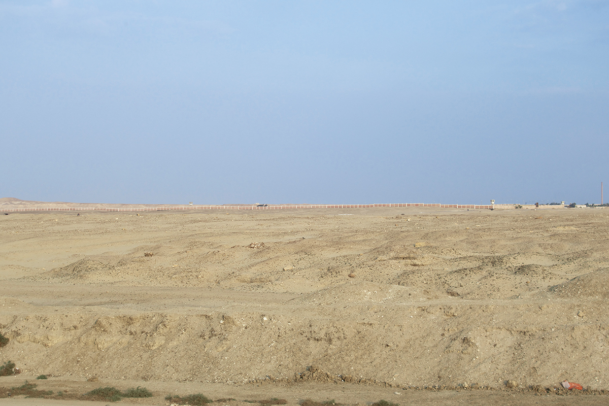
Site of Philadelphia seen from the south-west with the water treatment plant in the background (2015).
A pool located in the northern part of the urban area of Philadelphia seen from the north, Graeco-Roman period (2018).
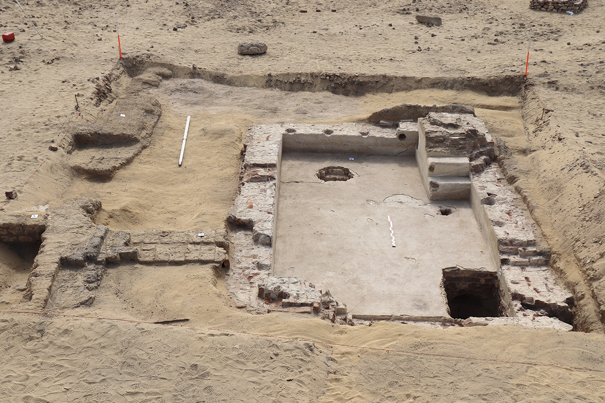
Limestone foundation layer of a warehouse (?) in the northern part of Philadelphia seen from the south, from the Ptolemaic period (2018).
A complete Egyptian amphora (AE 1/Ph. Type 1), Ptolemaic period (2018)

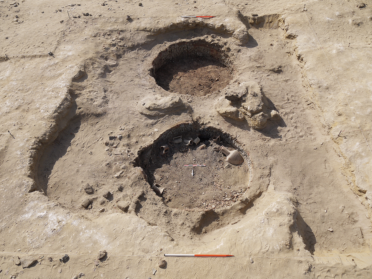
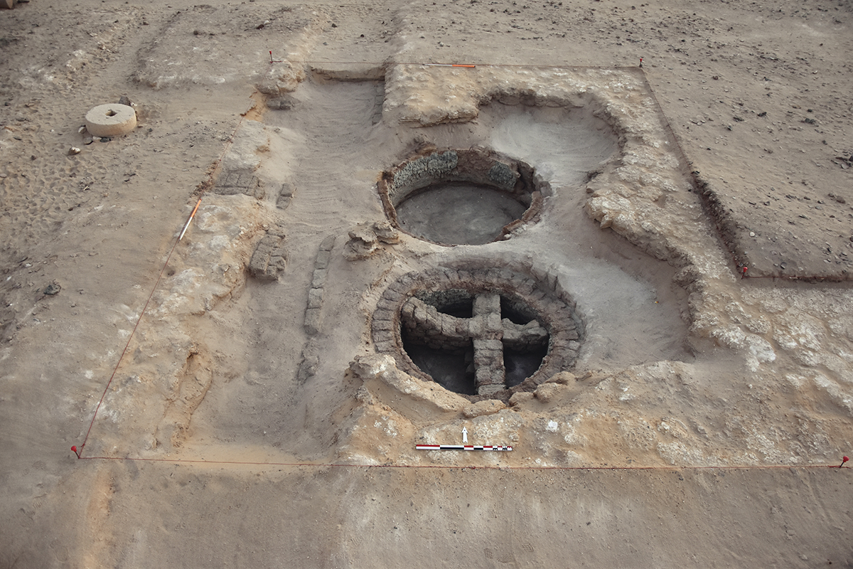
A set of kilns located in the southern part of the urban area of Philadelphia seen from the north, Ptolemaic period (2018).
© Ifao/ÖWA/S. Nannucci.
Philadelphie fait partie d’une série de fondations urbaines établies dans le Fayoum, le long d’un nouveau système d’irrigation, sous les premiers Ptolémées. Administrée comme un village aux époques hellénistique et romaine, elle serait tombée dans l’oubli vers le début du Ve s. apr. J.-C. L’existence de son habitat urbain (partie ouest du Kôm al-Kharaba al-Kabir Girza) a été révélée par de nombreux papyrus découverts, pour la plupart, de façon clandestine au tournant du XXe s.
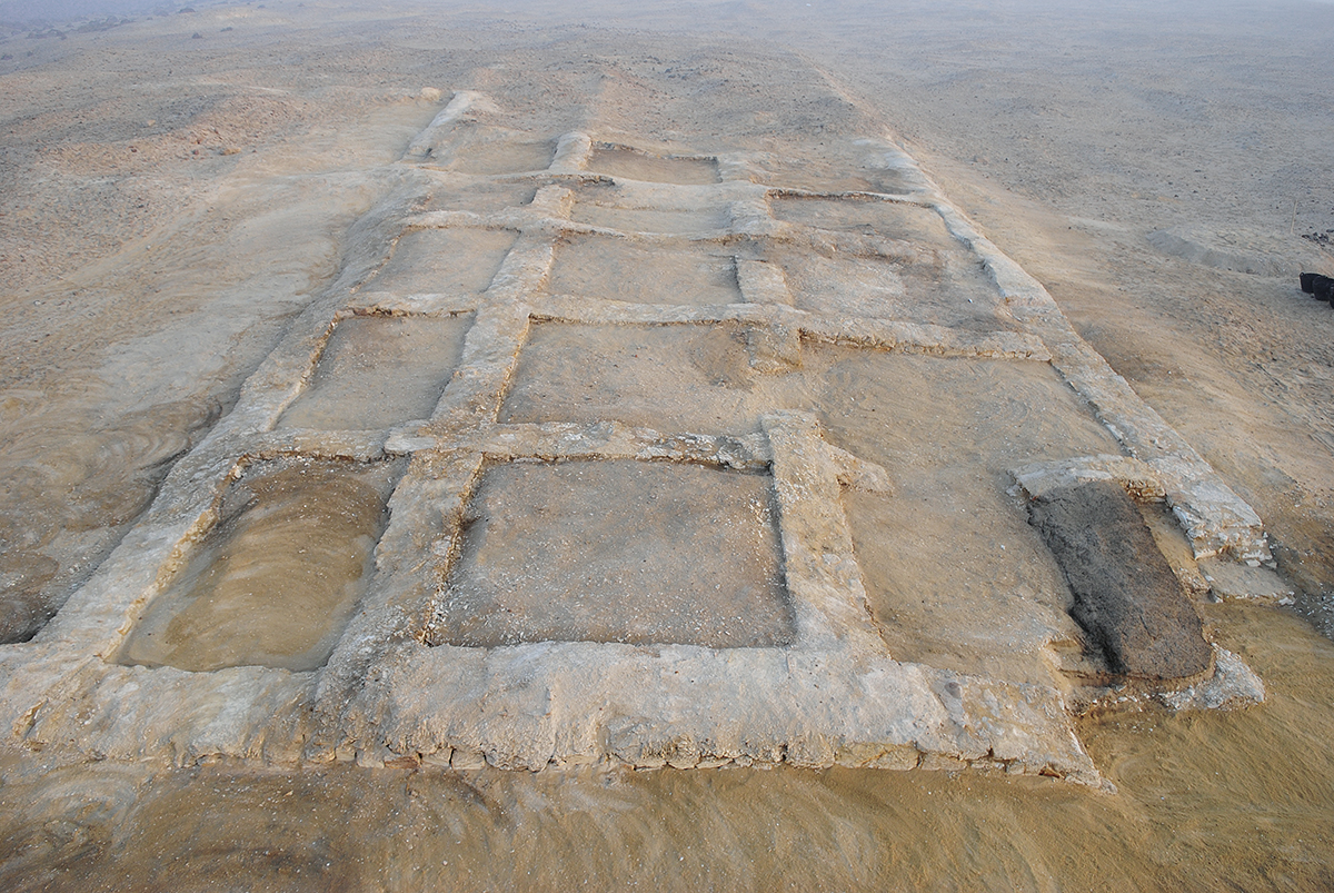
Le site se trouve dans l’angle nord-est du Fayoum. Il dominait une route commerciale reliant le Fayoum à la vallée du Nil et aboutissant à Kerkè (en grec), ou Ğirza (en arabe), destination majeure durant l’Antiquité et aujourd’hui encore. Il est séparé des terres arables à l’ouest par le canal moderne du Bahr Wahbi. Son territoire s’étend sur environ 2 km du nord au sud et 1,5 km d’est en ouest ; il est bordé au nord et au sud par des terres cultivées, au nord-est par une station d’épuration d’eau, et au sud-est par des collines désertiques. Le site, traversé d’ouest en est par la route de Girza, est ainsi scindé en deux zones. La partie urbaine de la zone nord est limitée par un ouadi peu profond, alors que celle de la zone sud souffre de l’invasion des cimetières modernes. Avant la présente mission, seule une opération archéologique avait été conduite, en 1908-1909, par Paul Viereck et Friedrich Zucker pour le compte des musées de Berlin. Leur recherche s’était limitée à la partie nord-ouest de la zone sud de l’habitat urbain. Un plan schématique n’en a été produit qu’en 1924, par Ludwig Borchardt. Ce plan concorde dans ses grandes lignes avec une vue aérienne prise par la Royal Air Force en 1925, sur laquelle on peut approximativement discerner le plan urbain, fort arasé aujourd’hui. Depuis 2015, nous nous interrogeons sur les éléments archéologiques encore récupérables sur ce site fort bouleversé par les activités des sebakhin et des chasseurs d’antiquités. Trois axes de recherche – à savoir l’urbanisme, le système hydraulique et les voies de communication avec les environs – ont été choisis et trois campagnes ont été menées sur le terrain jusqu’à présent.
Campagne 2015
La première saison a permis, pour la toute première fois dans l’histoire du site, une recherche combinant la topographie, la prospection géomagnétique et la céramologie. Un premier plan topographique a été dressé. La datation établie à partir des objets ramassés en surface montre que le IIe s. et le milieu du Ier s. av. J.-C. sont les mieux représentés et, dans une moindre mesure, les IIe et IIIe s. apr. J.-C. Les fondations d’un bâtiment en calcaire, de fonction inconnue, ont été mises au jour après un décapage. Des constructions subsistant d’un grenier (?), de bains romains, de caves de maison ont également été enregistrées. La prospection géomagnétique a révélé la présence de quartiers artisanaux (fours et canalisations) dans la zone sud, ainsi que des constructions en briques cuites le long de l’ancien canal.
Campagne 2018
Dans la zone sud, le décapage a rapidement atteint le substrat rocheux. La fouille de deux secteurs voisins a révélé des tranchées de fondations creusées dans la roche-mère et alignées nord-sud et est-ouest, ce qui confirme le plan orthogonal représenté sur l’esquisse de L. Borchardt pour cette partie du site. Une batterie de deux fours est assignable à la seconde moitié du IIIe s. av. J.-C., d’après la datation de nombreuses céramiques, dont une amphore complète. Il s’agit, d’après la présence de pâte non cuite, de la plus ancienne attestation de production d’amphores fayoumiques imitant le style rhodien. Dans la zone nord du site, nos efforts ont porté sur deux structures : un complexe architectural imposant, ainsi qu’un bassin. Le complexe semble s’étendre jusqu’aux environs de l’ancien canal à l’ouest, et pourrait avoir fait fonction d’entrepôt. Le bassin pourrait être un vivier. Une prospection préparatoire à la limite sud du territoire a révélé des vestiges d’élévations en briques crues évoquant une muraille. Au nord de cette structure linéaire menant vers la vallée du Nil, se trouvent une série d’anciennes carrières de calcaire, qui ont dû alimenter les constructions citadines.
Campagne 2019
Lors de cette campagne, nous avons choisi d’explorer davantage le quartier de potiers en ouvrant un sondage en S41, ainsi qu’une extension de S37 vers l’ouest. Les deux sondages comportent des vestiges de fours, dont l’existence a déjà été suggérée par des anomalies présentes sur des plans magnétométriques élaborés en 2015. La fouille en S38 a également été poursuivie en vue d’une plus ample étude du plan urbain orthogonal, et afin d’éclaircir la forte concentration de réponses magnétiques dans cette zone. En S41 ont été mises au jour des céramiques romaines susceptibles d’être datées de manière cohérente, tandis qu’en S38, nous avons pour la première fois mis en évidence une série de couches stratigraphiques résultant des transformations spatiales antiques, ainsi qu’un dépotoir. Enfin, nous avons ouvert trois sondages (S201-203) le long de la muraille au sud du territoire. Des éléments byzantins y ont été trouvés.
Ruey-Lin Chang (National Taiwan University)
Philadelphia is one of a series of urban settlements founded in the Fayum by the first Ptolemies along a new system of irrigation. Once a thriving village during Hellenistic and Roman periods, it fell into oblivion at the beginning of the 5th century AD. The existence of its urban environment (on the west part of the Kom el-Kharaba el-Kabir Girza) was revealed by the numerous Greek papyri discovered, for the most part, through illicit digging at the turn of the 20th century.
The site is located in the north-east corner of the Fayum. It dominated a commercial route which linked the Fayum to the Nile Valley and which ended at Kerkè (in Greek), or Ğirza (in Arabic), a major destination during Antiquity and which remains so today. To the west it is separated from arable land by the modern canal of Bahr Wahbi. Its territory extends for about 2 km from north to south and 1.5 km from east to west. To the north and the south it is bordered by cultivated land, to the north-east by a water-purification plant, and to the south-east by desert hills. The site, intersected from west to east by the Girza road, is thereby divided into two zones. The urban part of the northern zone is bounded by a shallow wadi, while that in the south has sustained an incursion of modern cemeteries.
Before the present mission, only one archaeological excavation had been conducted, in 1908-1909, by Paul Viereck and Friedrich Zucker, on behalf of the Berlin Museums. Their research was restricted to the north-west part of the south zone of the settlement. A schematic plan of it was only produced in 1924 by Ludwig Borchardt. In its main outlines, this plan is in agreement with the aerial picture taken by the Royal Air Force in 1925, on which the settlement plan, now heavily levelled, can be roughly distinguished.
Since 2015 we have been investigating those archaeological features which remain to be retrieved on this site, which has been severely disturbed by the activities of sebakhin and looters of antiquities. Three foci of research have been selected so as to gain an understanding of: the urban context; the hydraulic system; and communication routes in the local environment. To the present day, three seasons of work have been conducted.
Season 2015
During the first season, for the first time in the history of the site, research combining topography, geomagnetic surveying and pottery analysis was undertaken. The first topographic plan was drawn up. The date established from objects collected on the surface shows that the best represented periods are the 2nd century BC and the middle of the 1st century BC, with less evidence for the 2nd and 3rd centuries AD. Surface cleaning brought to light the foundations of a limestone building, of which the function remains unknown. Structures including a granary (?), Roman baths and cellars of houses were also recorded. In the southern area, the geomagnetic survey revealed the presence of quarters of workshops indicated by kilns and pipes, as well as fired brick structures along the ancient canal.
Season 2018
In the south zone, surface cleaning rapidly reached the bedrock. Excavation in the two neighbouring sectors revealed foundation trenches dug into the bedrock which were aligned north-south and east-west, which confirms the orthogonal plan drawn on L. Borchardt’s sketch for this part of the site. A set of two kilns can be assigned to the second half of the 3rd century BC, according to dating provided by numerous ceramic items, including a complete amphora. According to the presence of unbaked clay, this is the most ancient evidence for production in the Fayum of amphorae imitating the Rhodian style.
In the northern zone of the site, our efforts disclosed two structures: an impressive architectural complex as well as a water pool. To the west, the complex seems to extend as far as the vicinity of the ancient canal, and could have functioned as a warehouse. The pool could have been a fishpond. An initial survey at the southern limit of the area revealed remains of mud-brick elevations suggesting a wall. To the north of this linear structure, which leads towards the Nile Valley, is a series of ancient limestone quarries which probably provided material for the settlement buildings.
Season 2019
During this season we chose to further explore the potters’ quarter by opening up a trench in Sector 41, as well as making a westward extension in Sector 37. Both trenches revealed remains of kilns, the existence of which had already been suggested by anomalies on the magnetometric plots made in 2015. Excavations were also carried out in Sector 38 to study the urban orthogonal plan in greater depth and to throw light on the strong concentration of magnetic responses in this area. In Sector 41 Roman ceramic items were unearthed which were capable of providing coherent dating, while in Sector 38 we have evidence, for the first time, of a series of stratigraphic layers which are the result of ancient alterations in space management, as well as a rubbish dump. Finally, we opened three trenches in Sector 201-203 along the wall to the south of the settlement, where features of Byzantine date were found.
Ruey-Lin Chang (National Taiwan University)
تمثلُ فيلادلفيا جزءًا من سلسلة مؤسَّسات حَضَريَّة أُنشئت في الفيوم تحت حكم البطالمة الأوائل، على طول نظام الرَّيّ الجديد. فبعد أن كانت تُدار كقريةٍ في العصرين الهلِّينسْتيّ والرومانيّ، سقطت في النسيان قرابة بداية القرن الخامس الميلاديّ. ثم كشفت الكثير من البَرْديَّات عن وجود مساكن حَضَريَّة (الجزء الغربيّ من كوم الخرابة الكبير چِرزة)؛ حيث تم اكتشاف معظم هذه البَرْديَّات بطرق سِرِّيَّة عند منعطف القرن العشرين.
يقعُ موقعُ فيلادلفيا في الزاوية الشماليَّة الشرقيَّة للفيوم. وكان يسيطر على الطريق التجاريّ الذي يربط بين الفيوم ووادي النيل منتهيًا في كركى (باليونانيَّة)، أو ﭼِرزة (بالعربيَّة)، وهو مَقْصِد مهم خلال العصور القديمة ولا زال حتى اليوم. وتفصل قناةُ بحر وهبي الحديثةُ الموقعَ عن الأراضي الزراعيَّة في الغرب. وتمتد أراضيه قرابةَ كيلومترين من الشمال إلى الجنوب و1.5 كيلومتر من الشرق إلى الغرب؛ يحدُّه من الشمال والجنوب أراضٍ زراعيَّة، ومن الشمال الشرقيّ محطة تحلية المياه، ومن الجنوب الشرقيّ تلالٌ صحراويَّة. هذا الموقع، يعبُره طريق چِرزة من الغرب للشرق، مُقسِّمًا إيَّاه إلى منطقتين. ويحدُّ الجزءَ الحَضَرِيَّ من المنطقة الشماليَّة وادٍ ضَحْلٌ، بينما يُعاني الجزءُ الجنوبيُّ من غزو المقابر الحديثة.
قبل البعثة الحالية، قام كُلٌّ من ﭘﻭل ﭬﻴريك وفريدريش زوكر، من متاحف برلين، بإجراء عمليَّة أثريَّة واحدة فقط عام ١٩٠٨/١٩٠٩. واقتصرت أبحاثُهما على الجزء الشماليّ الغربيّ من المنطقة الجنوبيَّة للمساكن الحضريَّة. وفي عام ١٩٢٤، قام لودﭬﻴﺞ بورخارت، بوضعِ تصميمٍ إجمالىٍّ للموقع. يتوافقُ هذا التصميم، في خطوطه العريضة، مع الصورةِ التي التقطتها القوات الجويَّة المَلكيَّة جويًّا، عام ١٩٢٥، والتي من خلالها يمكننا تقريبًا تمييز التخطيط الحَضَرِيّ والذي تم هدمُه بشكل كبير اليوم.
منذ عام ٢٠١٥ ونحن نتساءل عن العناصر الأثريّة التي لا يزال يمكن جمعُها في هذا الموقع الذي خُرِّب نتيجةً لأنشطةِ السبَّاخين والباحثين عن الآثار. وقد تم اختيار ثلاثةِ محاور بحثيَّة: التخطيط الحَضَرِيّ، النظام الهيدروليكيّ وطرق الاتصال مع المناطق المحيطة. وأُجريت ثلاثُ بعثات ميدانيَّةٍ حتى الآن في هذا الشأن.
بعثة ٢٠١٥
سمح الموسمُ الأول، للمرَّة الأولى في تاريخ الموقع، بإجراء بحث يجمع بين الطبوغرافيا، والاستكشاف اﻟﭼيومغناطيسيّ وكذلك دراسة الخَزَفْ، وقد تم إعداد أول خريطة طبوغرافيَّة. يدل التأريخُ المُعدُّ من خلال المواد التي تم جمعها من سطح الموقع، أن القرن الثاني ومنتصف القرن الأول ق. م. هما الأفضل تمثيلًا، وبدرجة أقل، القرنان الثاني والثالث الميلاديَّان. ونتيجةً لعملية التنظيف، تم الكشفُ عن أساساتِ مبنًى من الحجر الجيريّ، وظيفتُه غير معروفة. كما تم أيضًا تسجيل مبانٍ متبقية لمخزن (؟)، حمَّامات رومانيَّة وأقْبيَة منازل. كما كشف المسحُ اﻟﭼيومغناطيسيّ عن وجود مناطق حِرَفيَّة (أفران وأنابيب) في المنطقة الجنوبية؛ وكذلك إنشاءات من الطوب المحروق على طول القناة القديمة.
بعثة ٢٠١٨
وفي المنطقة الجنوبية، سرعان ما بلغت عمليَّةُ التنظيف الطبقةَ الصخريَّة وكشفت أعمال التنقيب في منطقتين متجاورتين عن خنادقِ الأساساتِ المحفورة في الصخور الأصليَّة والتي تصطَفُّ على مسار شماليّ-جنوبيّ وشرقيّ-غربيّ؛ مما يؤكِّد التخطيطَ المتعامدَ الممثلَ في الرسمِ التخطيطيِّ للودﭬﻴﺞ بورخارت لهذا الجزء من الموقع. وتم تحديد مجموعة أواني فُرْنَيْن قد تعود للنصف الثاني من القرن الثالث الميلاديّ؛ وذلك وفقًا لتأريخ الكثير من قطع الخَزَفْ، بما في ذلك أمفورة كاملة. ووجودُ طينٍ غير محروق هو أقدم شهادة على إنتاج أمفورات الفيوم التي تحاكي الطراز الخاص برودس.
أما في المنطقة الشماليَّة للموقع، فركَّزت جهودنا على هيكلين: مجمع معماريّ ضخم، بالإضافة إلى بِركة. ويبدو أن المجمع يمتدُّ على مقربةٍ من القناة القديمة في الغرب، وقد يكون بمثابة مستودع، وربما كانت البِرْكةُ حوضًّا سمكيًّا. وقد كشف المسحُ التحضيرىُّ في الحدِّ الجنوبيّ من الإقليم عن بقايا ارتفاعاتٍ من الطوبِ اللَّبِن تشيرُ إلى جدارِ سور. وشمال هذا الهيكل المستقيم المُؤدِّى إلى وادي النيل، هناك سلسلةٌ من المَحاجِر القديمةِ للحجر الجيريّ، التي لا بُدَّ وأنها كانت نقطةَ إمدادِ المنشآتِ الحضريَّة.
بعثة ٢٠١٩
خلال البعثة الأخيرة، اخترنا مواصلةَ استكشافِ حي الفَخَّاريِّين بشكلٍ أكبر؛ وذلك من خلال إجراء المَجسِّ في س٤١، بالإضافة إلى امتداده من س٣٧، ناحية الغرب. وقد كشف المجسَّان عن بقايا أفران، أُشِيرَ لوجودها بالفعل نتيجةَ ظهورِ شذوذٍ في الخرائط المغناطيسيَّة التي تم إعدادُها عام ٢٠١٥. واستمرت أعمال التنقيب في س ٣٨ لدراسةٍ أوسعَ للتصميم الحَضَرِيّ المتعامد، ولإيضاح التركيز العالي للاستجابات المغناطيسيَّة في هذه المنطقة. في س٤١، تم الكشفُ عن قطعٍ من الفَخَّارِ الرومانيّ الذي يمكن تأريخه على نحوٍ مُتَّسق، بينما في س ٣٨ قمنا بتسليط الضوء للمرة الأولى على سلسلةٍ من الطبقاتِ الأرضيَّةِ الناتجةِ عن التحوُّلات المكانيَّة القديمة؛ وكذلك عن مستودع النُّفايات. وأخيرًا، تم إجراء ثلاثة مجسَّات (س٢٠١-٢٠٣) على طول السور، جنوب الإقليم، حيث تم العثور على عناصر بيزنطيَّة.
روي-لين تشانج (جامعة تايوان الوطنيَّة)
Bibliographie
- P. Viereck, F. Zucker, Ägyptische Urkunden aus den Staatlichen Museen VII. Papyri, Ostraka und Wachstafeln aus Philadelphia im Fayûm, BGU, Berlin, 1926.
- P. Davoli, L’archeologia urbana nel Fayyum di età ellenistica e romana, Missione Congiunta delle Università di Bologna e di Lecce in Egitto 1, Naples, 1998.
- P. Schubert, Philadelphie, un village égyptien en mutation entre le iie et le iiie siècle ap. J.C., SBAW 34, Bâle, 2007.
- W. Clarysse, K. Vandorpe, H. Verreth et al., Graeco-Roman Archives from the Fayum, CollHell-KVAB 6, Leuven, 2015.
- S. Marchand, R.-L. Chang, S. Nannucci, « Philadelphie 2018. Amphores égyptiennes locales AE 1 en pâte calcaire. Époque ptolémaïque, seconde moitié du iiie s. av. J.C. », BCE 28, 2018, p. 125-154.