Kôm Abou Billou
| Noms anciens | Mefkat, Térénouthis |
| 10.34816/ifao.7309-e83c | |
| 028174763 | |
| Missions Ifao depuis | 2012 |
Kôm Abou Billou et l’urbanisme du delta occidentalOpération de terrain 17113
Responsable(s)
![]() Sylvain Dhennin (IFAO,CNRS, UMR 5189 HiSoMA)
Sylvain Dhennin (IFAO,CNRS, UMR 5189 HiSoMA)
Partenaires
Cofinancements
Dates des travaux
septembre - octobre
Rapports de fouilles dans le BAEFE
2021 : 10.4000/baefe.5794
➣ Site(s) de la mission
Participants en 2026
| Sylvain Dhennin | archéologue, chargé de recherche | IFAO,CNRS, UMR 5189 HiSoMA |
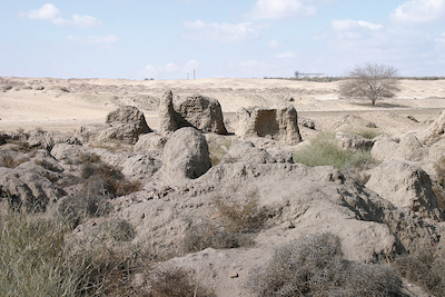
General view of the Kom Abu Bellu site from the east.

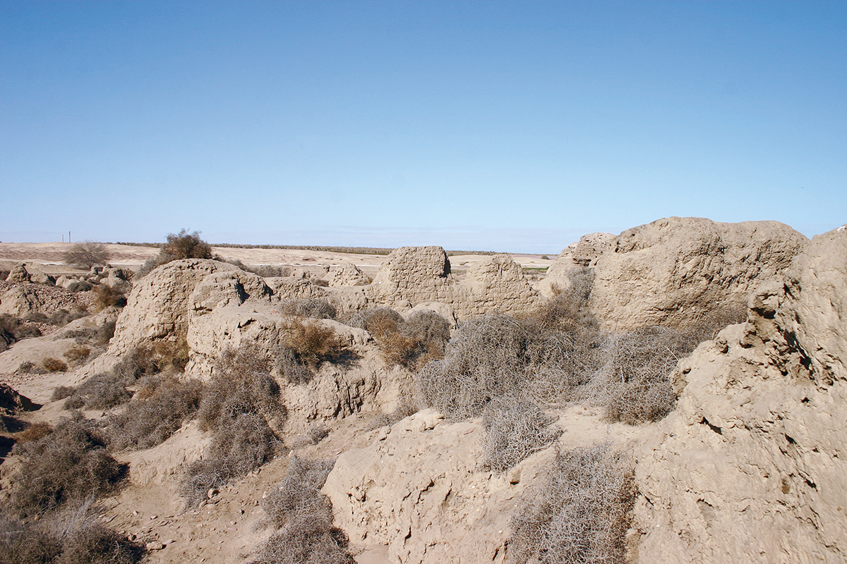
The ruins of Terenuthis.
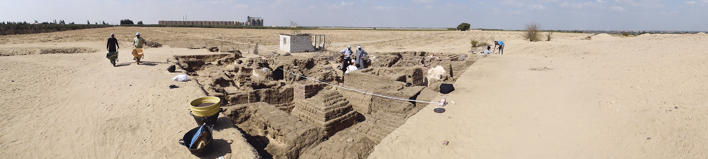
Overview of the excavated area of the necropolis (2017).
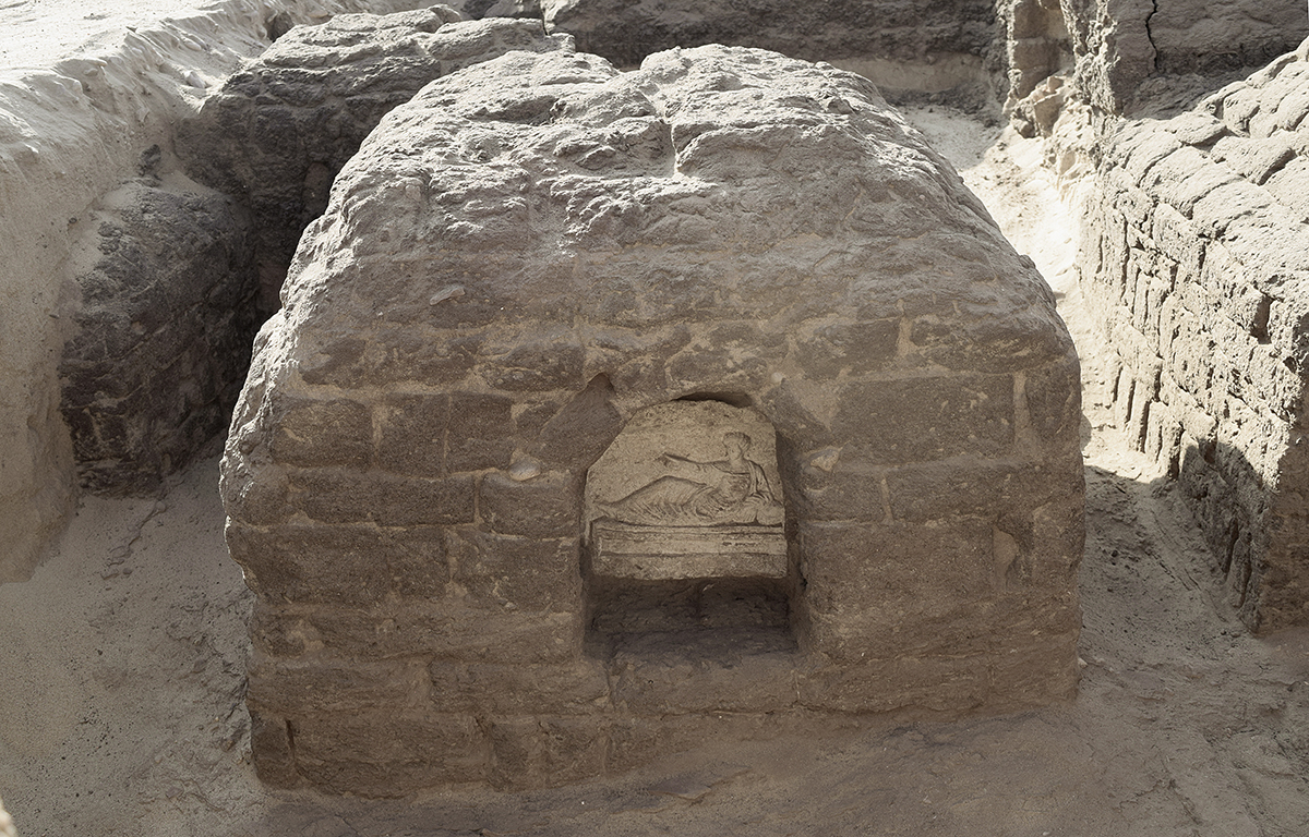
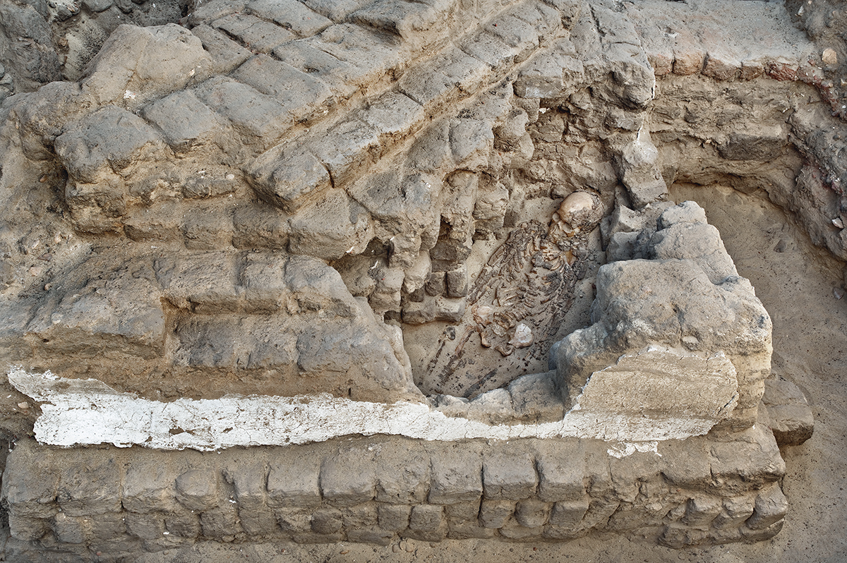
Front view of Galatia’s tomb in 2017 with its funeral stele at the front.
© Mission Kôm Abou Billou/T. Nicq, UMR 8164 HALMA.
© Mission Kôm Abou Billou/T. Nicq, UMR 8164 HALMA.
Les premières fouilles ont été menées par l’Egypt Exploration Fund (EEF) en 1888. Elles ont concerné plusieurs secteurs, mais surtout la partie occidentale de la nécropole, où des tombes de différentes époques furent mises au jour. Peu d’informations ont été publiées, mais le matériel découvert est assez bien renseigné, notamment les nombreuses trouvailles épigraphiques. Le relais a été assuré en 1935 par le Kelsey Museum d’Ann Arbor, sous la direction d’Enoch Ernest Peterson. Les travaux n’ont duré qu’une campagne, en raison de difficultés financières, et n’ont jamais été publiés.
Les plus importantes opérations furent menées par le service des Antiquités, entre 1969 et 1975. Il s’agit de fouilles de sauvetage, conduites lors du creusement du canal al-Nasseri, qui transperce aujourd’hui le site du sud-est au nord-ouest. Trois secteurs ont été fouillés, dont une grande partie a, depuis, été remise à l’agriculture. Les croquis publiés alors indiquent que l’étendue du site était beaucoup plus importante que la portion conservée de nos jours et représentait plus de 4 km nord-sud. Les fouilles ont été d’importance : des inhumations d’époque pharaonique et une grande partie de la nécropole gréco-romaine ont été mises au jour. En dépit de son potentiel et de son importance stratégique, le site reste très mal connu et souffre d’un déficit important dans son étude. Mefkat et surtout Térénouthis faisaient pourtant partie des lieux importants du delta occidental et leur étude est aujourd’hui nécessaire dans la perspective d’une restitution de l’organisation de la marge du delta du Nil.
La mission française est active depuis 2013 sur le terrain. Elle est aujourd’hui soutenue par l’Ifao et le laboratoire HiSoMA (UMR 5189), sous la direction de Sylvain Dhennin. Le bon état de conservation du site et son utilisation sur la longue durée permettent d’en envisager une approche globale. Les problématiques ont donc été centrées sur l’urbanisme et ses mutations, ainsi que sur l’évolution des fonctions présentes dans la ville : habitat, ateliers artisanaux, temple, nécropole. Par un travail sur les archives, la mission a également pour objectif de remettre en perspective les données issues des fouilles anciennes inédites, en les éclairant par les données issues du terrain et des nouvelles méthodes. Jusqu’à présent, les recherches de la mission ont été poursuivies selon trois axes principaux : l’étude urbaine centrée sur la cartographie et l’analyse spatiale, l’étude du temple comme marqueur de l’espace dans le temps et celle de la nécropole romaine, comme espace funéraire et social.
Afin de mener une première analyse spatiale et fonctionnelle des niveaux de surface, une prospection générale a été conduite. Elle a eu pour objectif la détermination des différents espaces de la ville lors de son abandon. Cette première approche du terrain ne correspond qu’à l’état le plus récent de son organisation, mais elle a permis de modifier complètement la vision du site présentée par les schémas anciennement publiés.
En surface, l’amplitude chronologique s’étend du VIIe s. av. J.-C au XIIe s. apr. J.-C. Les niveaux les plus anciens, marqués par des concentrations céramiques, affleurent suite à l’usure récente des sols dans la partie ouest du site. Immédiatement au nord de ceux-ci, se trouve une enceinte de brique crue de 125 m de côté et 8 m de large, des dimensions exceptionnelles pour un site secondaire du Delta. Celle-ci, déjà repérée sur les images satellite, correspond vraisemblablement à l’enceinte du téménos d’Hathor de Mefkat, déesse principale de la ville. De chaque côté du canal coupant le site en deux, des zones d’habitat bien préservées, avec des murs conservés en élévation sur plusieurs mètres en surface, ont fait l’objet de premières fouilles en 2017. Les premières observations montrent qu’il s’agit de la ville impériale et byzantine.
La surface étendue de l’intérieur de l’enceinte du temple (1,6 ha), nous a conduit à opter pour une approche globale de l’édifice. Un relevé photographique complet par cerf-volant a été effectué, accompagné d’une prospection magnétométrique. La carte obtenue permet de déterminer le tracé complet du dernier état de l’enceinte, mais met aussi en évidence plusieurs phases de construction antérieures. Afin d’assurer la chronologie, un premier sondage a été ouvert dans l’angle nord-ouest de la structure. Les aménagements internes du temple y sont apparus. Leur fouille a débuté et a permis la mise au jour des premiers niveaux pharaoniques, avec une occupation domestique d’époque saïto-perse qui semble avoir été à l’origine adossée au mur d’enceinte intérieur du temple.
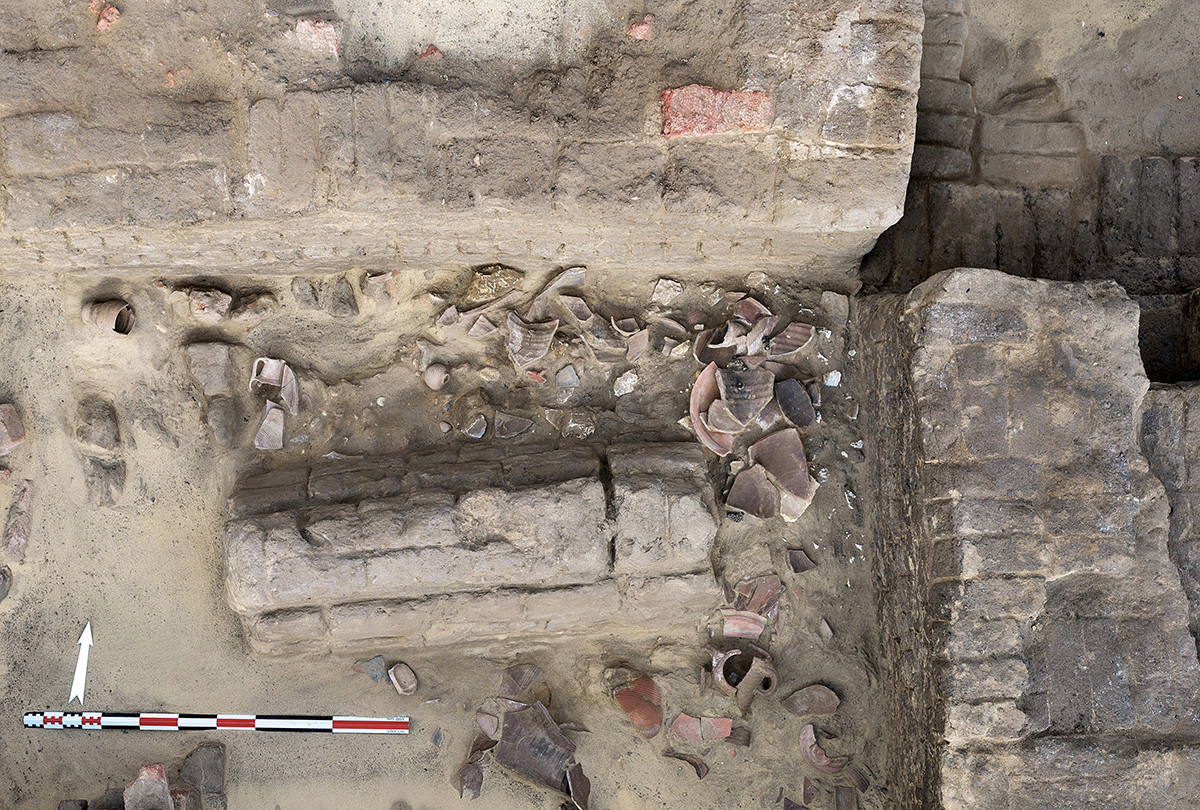
La prospection a montré que les franges ouest et nord du site ne présentaient aucune trace d’occupation postérieure à l’époque romaine. La nature du matériel céramique, la présence d’ossements et de nombreux fragments d’enduits peints avaient alors conduit à identifier cette zone à la nécropole, hypothèse confirmée par la prospection magnétométrique. Les tombes fouillées depuis 2014 sont d’époque romaine, réparties en 3 phases entre le Ier et le IVe s. L’occupation est très dense, avec de nombreux remplois de tombes. Elles sont construites en briques crues et présentent une organisation similaire : une superstructure en briques, de forme variable, avec une niche en façade comportant une stèle funéraire et une table d’offrande.
Sylvain Dhennin (CNRS, UMR 5189)
he first excavations were conducted by the Egypt Exploration Fund (EEF) in 1888. They included several areas, but especially the western part of the necropolis where tombs of different periods were exposed. Little information was published, but the material discovered is quite informative, especially the numerous epigraphic pieces of documentation. Interest was shown again in 1935 by the Kelsey Museum of Ann Arbor, under the direction of Enoch Ernest Peterson. The excavations lasted only one season, due to financial difficulties, and details of them were never published.
The most important activities were conducted by the Antiquities Service between 1969 and 1975. They were rescue excavations conducted during the digging of the el-Nasseri canal, which today cuts through the site from south-east to north-west. Three areas were dug which, to a large extent, have been returned to agriculture since that time. The published sketches indicate that the extent of the site was much greater than what is preserved today, being more than 4 km from north to south. The excavations were significant: burials of the Pharaonic period and a large part of a Graeco-Roman necropolis were exposed. Despite its potential and its strategic importance, the site remains little known and lacks significant analysis. Mefkat, and even more Terenuthis, were among the important towns in the Western Delta. Their study today is vital from the perspective of reconstructing how the margins of the Nile Delta were organised.
French missions have been active at the location since 2013. Today they are conducted by the IFAO and the laboratory HiSoMA (UMR 5189) under the direction of Sylvain Dhennin. The site’s good state of preservation and its use over a long period have enabled a broad-spectrum approach to be adopted to its occupation. The focus has concentrated on questions concerning urbanism and its alterations, as well as the evolution of activities which took place in the city, especially those relating to residential areas, artisan workshops, the temple and the necropolis. By studying the archives, the mission also aims to bring together data produced during former unpublished excavations and cast light on them through data gathered in recent excavations and from new methods adopted. Until now, the mission’s research has followed three main focuses of attention: an urban study based on cartography and spatial analysis; the study of the temple as a spatial marker over time; and the Roman necropolis as funerary and social space.
In order to conduct an initial spatial and functional analysis of surface layers, a general survey was carried out. Its aim was to determine different city spaces at the time it was abandoned. This landscape approach only corresponds to its most recent state, but it has allowed the view of the site offered by previously published sketches to be completely revised.
On the surface the chronological time-frame extends from the 7th century BC to the 12th century AD. The most ancient levels, indicated by ceramic material, occur on the western part of the site, due to recent weathering of the soil. Immediately to the north of this area is a mud-brick enclosure of 125 m long and 8 m thick, an exceptional size for a secondary site of the Delta. This, already located on satellite images, most likely corresponds to the temenos enclosure of Hathor, the principal goddess of the town. On each side of the canal which cuts the site in two, the residential areas are well-preserved, with walls on the surface surviving to a height of several metres. These were the subject of the first excavations in 2017. The first observations indicate that this belonged to the Imperial Roman and Byzantine town.
The large-scale area within the temple enclosure (1.6 ha) led us to adopt a multi-facetted approach to the structure. Photographic imaging by a kite was undertaken, accompanied by a magnetometric survey. The map obtained enabled us to determine the complete outline of the enclosure’s last phase of existence, as well as indicating several phases consisting of previous structures. In order to clarify the chronology, a first sondage was opened in the north-west corner of the building. Internal modifications to the temple then became apparent. Their excavation has enabled the first pharaonic levels to be exposed, in addition to a Saite-Persian period domestic occupation which seems to have originally been constructed against the interior of the temple enclosure wall.
Surveying has shown that the western and northern fringes of the site present no traces later than the Roman period. The nature of the ceramic material, the bone material present and the numerous fragments of painted plaster have led to the identification of this area as a necropolis, a hypothesis confirmed by magnetometric surveying. The tombs excavated since 2014 date to the Roman period, being divided into three phases between the 1st and 4th centuries AD. Occupation then was very dense, with numerous tombs being reused. Built of mud-brick, they show a similar form: their brick superstructure is of variable shape, with a niche being in the façade which includes a funerary stela and an offering table.
Sylvain Dhennin (CNRS, UMR 5189)
في عام 1888، أجرت جمعيَّةُ استكشافِ مصر (EEF) أوَّل عمليات تنقيب وتناولت عدةَ قطاعاتٍ ولكن بشكلٍ أخصَّ القطاع الغربيّ من الجبَّانة؛ حيثُ كُشِف عن مقابر من عصورٍ مختلفة. ولم تُنشر سوى معلوماتٍ قليلةٍ عن هذه الأعمالِ غير أن المواد المُكتشفَة، تمَّ توثيقُها بشكلٍ مقبول؛ خاصة تلك المتعلقةَ بالعديد من الاكتشافات الإبيجرافية. ثم تولَّى مُتْحف كيلسي للآثار في آن آربر استكمالَ الأعمالِ تحت إدارة إينوك أ. پيترسون، ولكن لم تستمرَّ الأعمالُ سوى لبعثةٍ واحدةٍ بسبب صعوباتٍ ماليَّةٍ ولم يُنشَر أيُّ شىء عنها.
وكانت أهم العمليَّات التي قامت بها إدارةُ الآثارِ في الفترةِ ما بين 1969 و1975، وكان الأمرُ يتعلقُ بعمليات تنقيب إنقاذي أُجريت في زمنِ حفر الرَّيَّاح الناصريّ، الذي يعبرُ اليوم الموقعَ من الجنوبِ الشرقيّ إلى الشمال الغربيّ. وتمَّ التنقيبُ في ثلاث قطاعاتٍ؛ حيث تحولَ جزءٌ كبيرٌ منها اليوم إلى الزراعة. أما الرسومات التخطيطية التي نُشرت في ذلك الوقت، فهي تشيرُ إلى أن اتِّساعَ الموقعِ كان أكبرَ بكثيرٍ من الجزءِ المحفوظِ اليوم، ويمثلُ أكثرَ من 4 كيلومترات من الشمال إلى الجنوب. تميَّزت أعمالُ التنقيب التي أُجريت بأهميَّتها؛ حيثُ كُشِفَ عن دفنات من العصر الفرعونيّ، وجزءٍ كبيرٍ من الجبَّانةِ اليونانيَّةِ الرومانيَّة. وبالرغمِ من مكنونِه الواعدِ وأهميَّته الاستراتيـﭼيَّة، فإن الموقعَ لا يزالُ غيرَ معروفٍ ويفتقر إلى الدراسات، على الرغمِ من أن مفكت وبالأخصِّ تيرينوثيس Térénouthis كانتا من الأماكنِ المُهمَّةِ في الجزءِ الغربيّ من الدلتا، ودراستُهما اليوم لازمةٌ من أجلِ التوصُّل لإعادةِ صياغةِ طريقةِ تنظيمِ شريطِ دلتا النيل.
والبَعْثةُ الفرنسيَّة تنشطُ في الموقع منذ 2013، ويدعمها حاليًّا المعهد الفرنسي للآثار الشرقية ومعمل HiSoMA تحت إدارة سيلڨان دينان. وحالةُ الحفظِ الجيدةِ للموقع، واستخدامه عبر أزمنةٍ طويلةٍ يسمحان بتنفيذِ مقاربةٍ شاملةٍ له. وتمحورت الإشكاليَّات حول العمران، والطفرات التي شهدها؛ وكذلك تطوُّر الأعمالِ الممثلةِ في المدينة: السَّكَن، ورش حِرفيَّة، معبد، جبَّانة، وتهدفُ البعثةُ كذلك - عن طريقِ العملِ على الوثائقِ الأرشيفيَّة - إلى إعادةِ استعراضِ كُلِّ المعطياتِ الناتجةِ عن أعمالِ التنقيبِ القديمةِ والتي لم تُنشر، مع توضيحها من خلالِ المعطياتِ التي يسفرُ عنها البحثُ الميدانيّ والوسائلُ الحديثة. وحتى الآن تتبعُ الدراسةُ محاورَ ثلاثةً رئيسة: الدراسة العمرانيَّة التي تتمحور حول دراسة الخرائط وتحليل المكان، ودراسة المعبد كمُحدِّد للمكان في الزمن، ودراسة الجبَّانة الرومانيَّة في بُعْدَيْها: الجنائزيّ والاجتماعيّ.
ومن أجلِ إجراءٍ تحليلٍ أوَّليٍّ لحيزِ ووظائفِ مستوياتِ السطح، بدأنا عمليةَ مسحٍ عامٍّ بهدفِ تحديدِ المساحاتِ المختلفة للمدينة عند هَجْرها. هذه المقاربةُ الأولى الميدانيةُ لا تتعلقُ إلَّا بالحالةِ الأحدثِ لتنظيمها؛ ولكنها سمحت بالتغيُّر الكاملِ لرؤيتنا للموقع، رؤية قدَّمتها المخططات التي نُشرت قديمًا.
وعلى السطح، يمتدُّ النطاقُ الزمنىُّ من القرنِ السابع ق. م. إلى القرن الثاني عشر الميلاديّ. وتبرزُ المستوياتُ الأكثرُ قِدمًا والتي تميزُها تركزاتٌ ظاهرةٌ من الخَزَف، ذلك نظرًا لاستنزافِ التربةِ مؤخَّرًا عند الجزءِ الغربيّ من الموقع. وفي الشمال مباشرةً، يوجدُ سورٌ من الطوبِ اللَّبِن بطول 125م، وعرض 8 م، وهي مقاييسُ استثنائيَّةٌ بالنسبة لموقعٍ ثانويٍّ من مواقع الدلتا. ويُرجَّح أن هذا السورَ الذي التقطته الأقمارُ الصناعيَّة، هو سورُ معبدِ حتحور في مفكت، وهي المعبودةُ الرئيسةُ للمدينة. وعلى ضفَّتَي القناةِ التي تُقسِّم الموقعَ إلى جزءَين، تمتدُّ على مساحةِ عدةِ أمتار، مناطقُ سكنيَّةٌ في حالةِ حفظٍ جيدةٍ ذاتِ جدران قائمةٍ وبحالةٍ جيدةٍ، وكانت موضعَ أعمالِ التنقيبِ الأولى في عام 2017. وتشير الملاحظاتُ الأوليَّة للموقعِ إلى أنها مدينة الإمبراطورية الرومانيَّة والبيزنطيَّة.
والمساحةُ التي يحيطُ بها السورُ (6.1 هكتار) قادتنا إلى تَبنِّى مقاربةٍ شاملةٍ للصرح، فقمنا بعملِ رفعٍ فوتوغرافيّ بواسطةِ طائرةٍ ورقيَّة، رافقها مسحٌ مغناطيسيّ. والخريطةُ التي حصلنا عليها سمحت بتحديد مسارٍ كاملٍ للسورِ في حالته الأخيرة كما أظهرت كذلك عدةُ مراحل بناءٍ سابقة. وللتأكُّدِ من التسلسل الزَّمنيّ، قمنا بعمل عدة مجسَّات في الزاوية الشماليَّة الغربيَّة من الهيكل حيث أظهرت التخطيطَ الداخليَّ للمعبد. وبدأت عمليَّاتُ التنقيبِ وكشفت عن الطبقاتِ الفِرْعونيَّةِ الأولى، وهي ذاتُ إشغالٍ سَكنيٍّ يرجعُ إلى عصرِ الحكمِ الصَّاوِيّ الفارسيّ، ويبدو أنها كانت في الأصل مستندةً إلى الجدارِ الداخليّ للمعبد.
أظهرت عمليَّاتُ المسحِ أن الشريطيْن الغربيّ والشماليّ للموقع لا يحملان أيَّةَ آثارٍ لإشغالٍ لاحقٍ للحقبةِ الرومانيَّة. طبيعةُ الموادِّ الخَزَفيَّة، ووجودُ عظام، والكثيرُ من قطَع الجيرِ المُلوَّن، أدَّى إلى تعريفِ هذه المنطقة على أنها الجبَّانَة، وهي الفرضية التي أكدها المسحُ المغناطيسىُّ. أمَّا المقابرُ التي تمَّ التنقيب بها منذ 2014، فهي ترجعُ إلى العصر الرومانيّ، وهي مُقسَّمةٌ إلى ثلاثِ مراحل تغطي الفترةَ ما بين القرنِ الأولِ والقرنِ الرابعِ الميلاديّ، وهي ذات إشغالٍ كثيفٍ جدًّا مع تَعدُّدِ إعادةِ استخدامِ بعضِ المدافن ذات التخطيطِ المُتشابه، فهي مبنيَّةٌ من الطوبِ اللَّبِن مع بِنيَة فَوْقيَّة من الطوبِ بأشكالٍ متنوعة، وكَوَّةٍ في الواجهة. وتشمل شاهدًا جنائزيًّا، ومائدةَ قرابين.
سيلڤان دينان (المركز الوطنيّ للبحث العلميّ-UMR 5189)
Bibliographie
- Z. Hawass, « Preliminary Report on the Excavations at Kom Abou Bellou », SAK 7, 1979, p. 75-87.
- A. Abd el-Aal, « The Excavations of Abu Bellou’s Mound, Started, January 1979 », ASAE 65, 1983, p. 73-78.
- S. Dhennin, « Térénouthis - Kôm Abou Billou : une ville et sa nécropole », BIFAO 111, 2011, p. 105-127, en ligne, https://www.ifao.egnet.net/bifao/111/07/.
- S. Dhennin, « Mefkat, Térénouthis, Kôm Abou Billou, nouvelles recherches archéologiques à l’ouest du Delta », BSFE 189, 2014, p. 8-25.
- Page web Mefkat, Kom Abou Billou archivée (2016)