Tell el-Iswid
| 10.34816/ifao.3fdf-2fe5 | |
| 17731351X | |
| Missions Ifao depuis | 2007 |
Tell el-Iswid : un établissement du IVe millénaire dans le DeltaOpération de terrain 17115
Responsable(s)
![]() Nathalie Buchez (INRAP)
Nathalie Buchez (INRAP)
![]() Samuel Guérin (INRAP)
Samuel Guérin (INRAP)
Partenaires
![]() 🔗 Institut français d’archéologie orientale (IFAO)
🔗 Institut français d’archéologie orientale (IFAO)
![]() 🔗 Institut national de recherches archéologiques préventives (INRAP)
🔗 Institut national de recherches archéologiques préventives (INRAP)
![]() 🔗 Travaux et recherches archéologiques sur les cultures, les espaces et les sociétés (TRACES, CNRS, UMR 5608)
🔗 Travaux et recherches archéologiques sur les cultures, les espaces et les sociétés (TRACES, CNRS, UMR 5608)
Cofinancements
Dates des travaux
octobre - décembre
Rapports de fouilles dans le BAEFE
2022 : 10.4000/baefe.7959
2021 : 10.4000/baefe.5608
2019 : 10.4000/baefe.768
Participants en 2024
| Nathalie Buchez | archéologue | INRAP | |
| Samuel Guérin | archéologue | INRAP | |
| Jade Bajeot | archéologie préhistoire, doctorant | Sapienza Università di Roma | |
| François Briois | archéologue | CNRS - UMR 5608 | |
| Deborah Casini | archéologue | université de la Sapienza de Rome | |
| Rachid El Hajaoui | modélisation 3D | Inrap | |
| Abdekkatif Elshafaey | université du Caire | ||
| Attia Elshafaey | université du Caire | ||
| Aline Emery-Barbier | palynologue | Maison de la recherche (Nanterre) | |
| Joséphine Lesur | archéozoologue, maître de conférences | MNHN | |
| Béatrix Midant-Reynes | archéologue protohistorienne, directeur de recherche émérite | CNRS, UMR 5608 TRACES | |
| Mathilde Minotti | archéologue, doctorant | UMR Traces | |
| Sidonie Preiss | archéobotaniste | Université de Leuven | |
| Jérome Robitaille | tracéologue, doctorant | EHESS | |
| Camille Vanhove | archéologue | ||
| Julie Villaeys | égyptologue, doctorant | Université Paris 4 Sorbonne |
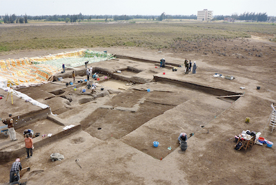
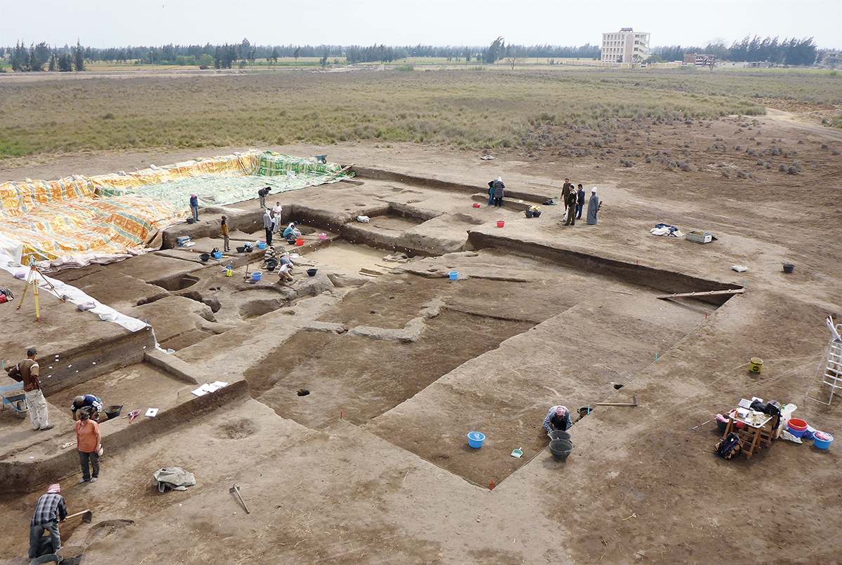
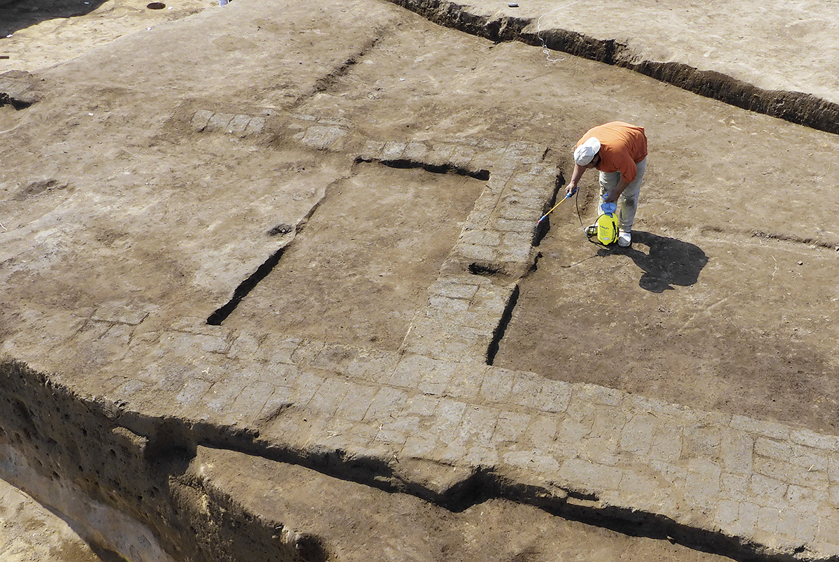
General view of the excavation on the south-western part of the Tell.
Mud-brick architecture of the Naqada period.
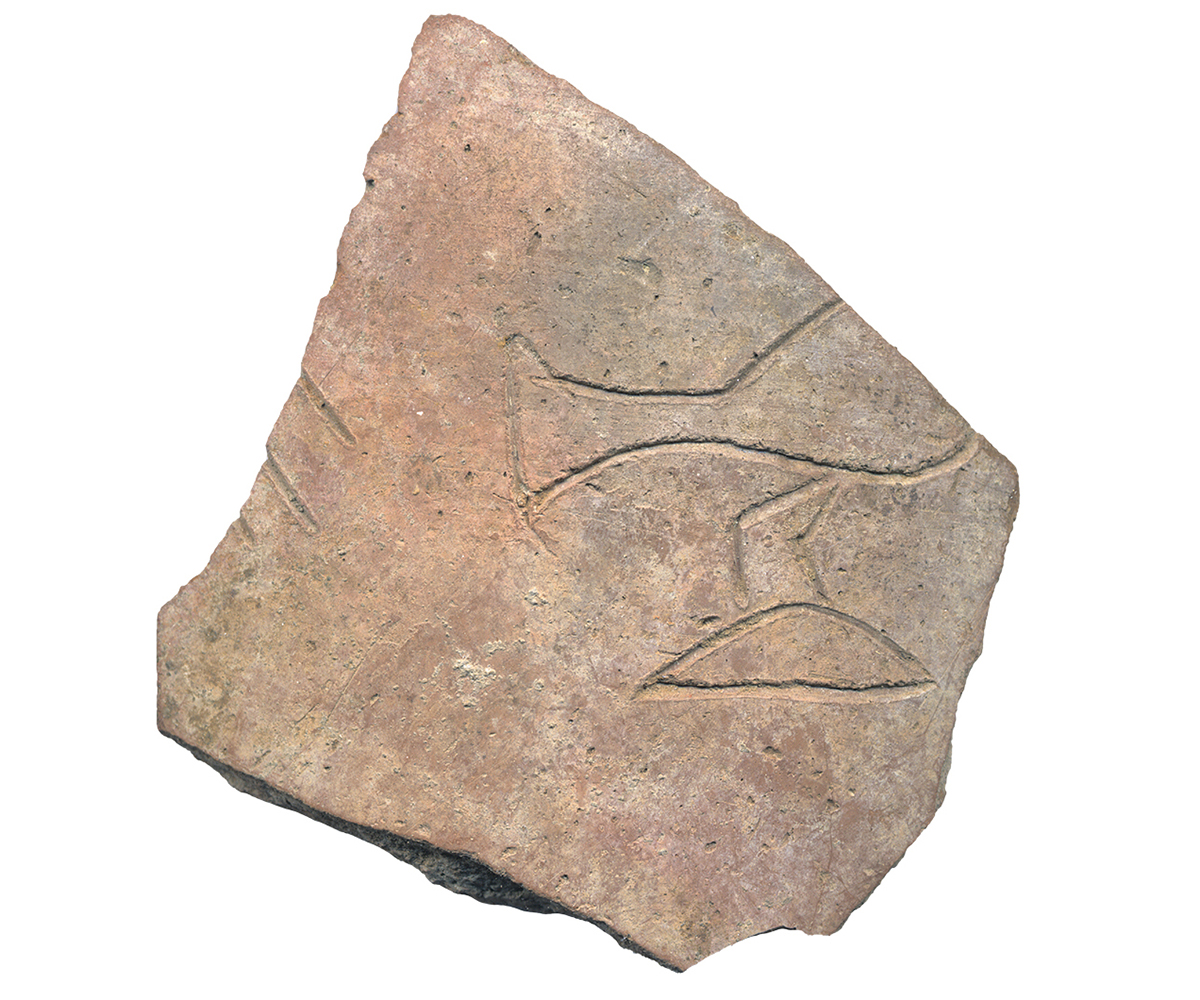
Jar sherd inscribed with the name Iryhor found in the largest room in the north building.
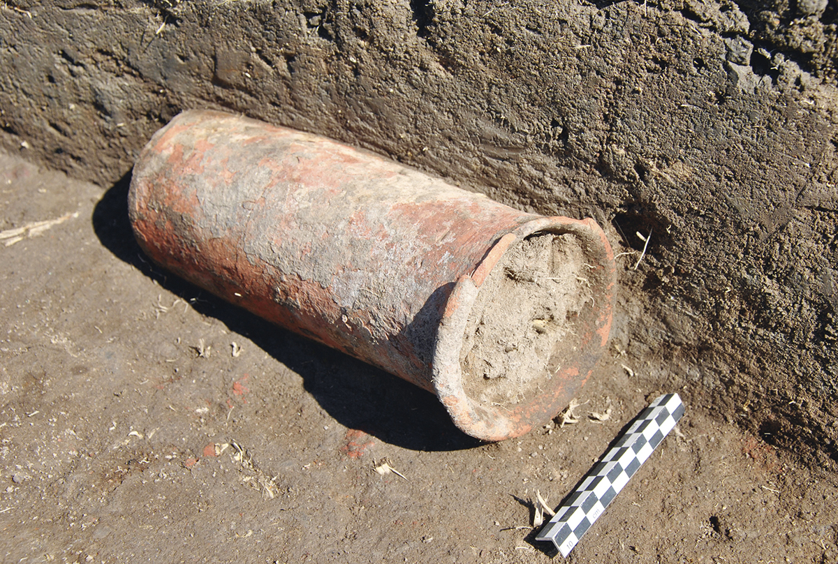
Pot from the Naqada period (Naqada IIIB), local production using a non-local techniques.
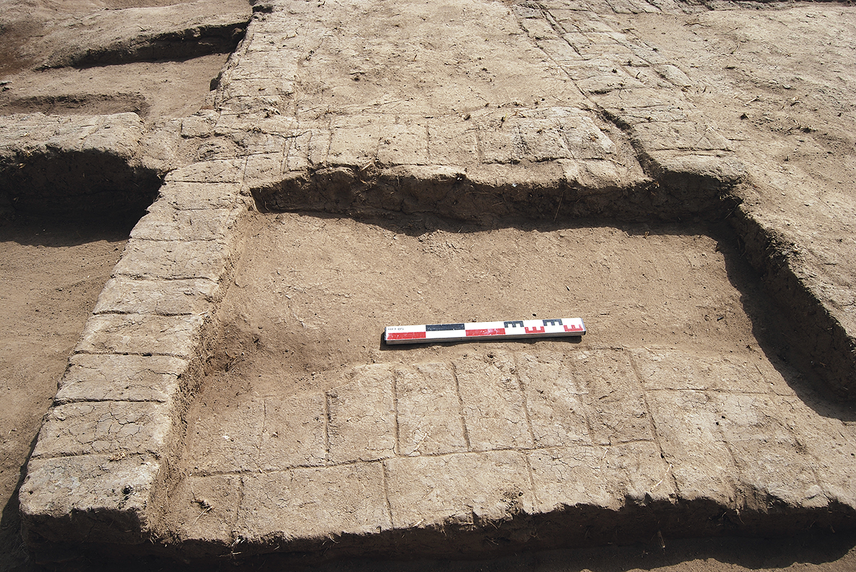
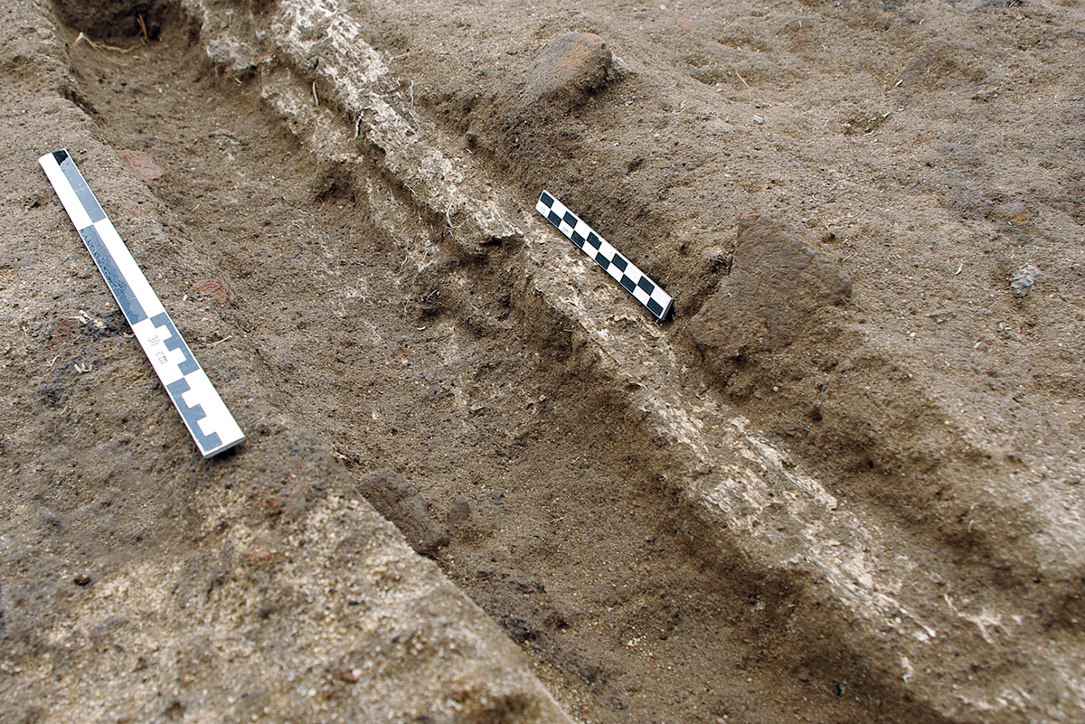
The insubstantial architecture representing Lower Egyptian Culture: construction trench with calcified wooden remains.
Mud-brick architecture discovered in a context dating to the Cultures of Lower Egypt found at Tell el-Iswid and at the nearby Polish excavation site of Tell el-Farkha. The outlines of a room built at an angle to the thick enclosure walls.
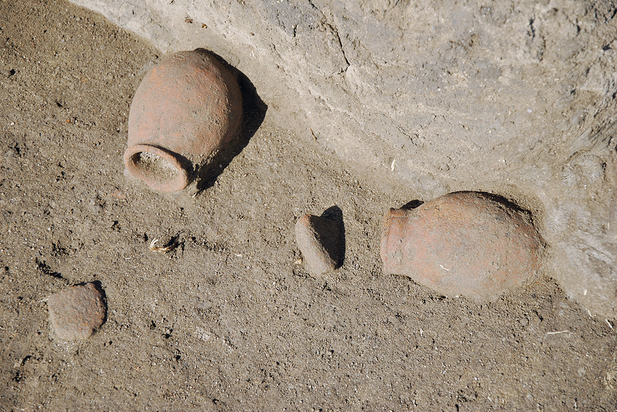
Small pots made according a technological tradition of the Cultures of Lower Egypt discovered against a wall with their stoppers.
Le Delta : un environnement particulier, une approche géo-archéologique nécessaire (2006-2010)
On a longtemps considéré qu’en raison de son caractère hostile par nature (inondations, marécages, moustiques), le Delta n’avait pas connu d’occupation humaine avant qu’un minimum technologique le rende habitable, à l’époque pharaonique. On sait désormais que les sites prédynastiques sont surtout peu aisés à détecter. Dans le Delta, les hommes se sont nécessairement installés sur les gezira – ces buttes sableuses constituées par les dépôts du Nil du Pléistocène –, qui seules émergeaient lors des crues annuelles. Au fil du temps, les limons des crues ont recouvert une partie des sites, puis finalement ce paysage a été profondément remodelé à partir du xixe s. lorsque les travaux hydrauliques (barrages) ont rendu possible la mise en culture pérenne des terres et qu’un processus de nivellement des gezira et des tells s’est engagé.
Ainsi, le site prédynastique de Tell el-Iswid, plus précisément localisé dans le Delta oriental, à 40 km au nord-est de la ville actuelle de Zagazig, dans la province de la Sharqiyah, n’a-t-il été découvert qu’en 1987 à l’occasion de prospections par carottages profonds et sondages menés par une équipe de l’université d’Amsterdam. À partir de 2006, l’Institut français d’archéologie orientale (Ifao) a entrepris une démarche intégrée à un programme d’étude des interactions entre hommes et environnement (ANR Gezira) visant à préciser le potentiel archéologique du site et à reconnaître la topographie ancienne des lieux (toujours au moyen de carottages et de sondages archéologiques, mais aussi à partir d’une prospection magnétique). Les données acquises montrent que le tell d’aujourd’hui, de 12 ha, n’est qu’une partie d’un site ou d’un ensemble de sites se développant en bordure d’une vaste étendue sableuse désormais recouverte par les cultures. Autre information plus inattendue issue du croisement des observations à différentes échelles : la topographie actuelle est inversée. Les reconstructions successives des secteurs de l’habitat touchés par les crues ont généré d’importants exhaussements sur les points bas et ce qui était à l’origine le sommet de la butte sableuse se trouve aujourd’hui en contrebas. En effet, si l’habitat prédynastique est longtemps resté centré sur les versants nord, ouest et sud-ouest de l’éminence, il semble avoir gagné sur les zones inondables à la fin de la période et a alors été affecté par les épisodes de crue. Les données concordent aussi pour situer à la Basse Époque une dernière phase d’occupation extensive du tell, des indices plus ponctuels témoignant néanmoins d’une présence intermédiaire (IVe dynastie, XIe dynastie, fin de la Deuxième Période intermédiaire et début du Nouvel Empire).
Une documentation inédite sur l’évolution de l’espace domestique à la période nagadienne : les premiers résultats de la fouille extensive entreprise dans le secteur sud-ouest du tell (2011-2015)
Au terme des opérations de reconnaissance, une fouille a été engagée sur un secteur recelant des murs en brique crue de l’époque nagadienne qui se sont avérés appartenir à une architecture domestique. Ce type de contexte est peu documenté pour la période à l’échelle de l’Égypte, bien qu’il soit source de réflexions sur les modes de vie et sur l’organisation sociale.
Dans le cas de Tell el-Iswid, il a été possible de suivre les transformations d’un bâti à long terme et, ainsi, d’analyser les modalités d’évolution de l’espace domestique au moment où les premiers rois affirment leur pouvoir sur l’ensemble de l’Égypte (Nagada IIIB, dernier quart du IVe millénaire, d’après les mobiliers et un tesson gravé au nom d’Iryhor découvert dans une pièce). D’un côté, certaines élévations perdurent ou certaines limites demeurent en dépit des multiples remaniements, peut-être par ce que ces réaménagements se font dans le cadre contraint de la trame globale de l’habitat. De l’autre, dans une dernière étape, l’organisation spatiale n’a plus grand chose à voir avec celle des débuts. Deux corps de bâtiment identiques, au plan plus ramassé qu’avant, et chacun constitué de pièces de même module, prennent place de part et d’autre d’une cour, plus restreinte qu’avant. On n’y accédait que depuis l’un des bâtiments et, dans un dernier temps, le dispositif d’accès devient plus compliqué. Au travers des réorganisations, on décèle une plus grande emprise des surfaces construites et un processus de privatisation des espaces sans doute révélateur d’une évolution des rapports sociaux.
Les constituantes, la structuration et les transformations de l’habitat des Cultures de Basse Égypte : l’exploitation en cours d’une séquence stratigraphique complexe (2016-2019)
Les niveaux antérieurs aux bâtiments nagadiens correspondent à une impressionnante succession d’étroites tranchées et de petites fosses relevant des Cultures de Basse Égypte. Les vestiges de bois calcifiés mis au jour dans ces tranchées évoquent des architectures légères avec des éléments verticaux – de type canisse – enduits de terre et expliquent les incessantes reconstructions dont elles ont fait l’objet. Ces parois ou palissades, qui matérialisent de vastes ensembles pluricellulaires (espaces domestiques au sens strict ou zones d’activités ?), sont attestées tout au long d’une séquence stratigraphique de 1,50 m d’épaisseur pouvant représenter 200 à 300 ans d’occupation. Des évolutions se font néanmoins jour. L’apparition, vers le milieu de la séquence, de silos en grand nombre peut dénoter un accroissement des capacités de stockage et un passage vers une agriculture céréalière plus intensive. Peu après, alors que les échanges entre le Delta et la vallée du Nil s’intensifient, comme l’indique l’augmentation des mobiliers importés, on enregistre l’émergence d’une nouvelle tradition architecturale mettant en œuvre la brique crue.
On est là (vers la fin du second quart du IVe millénaire), à un moment où tout s’enchaîne rapidement. L’enjeu, qui repose sur une analyse stratigraphique maîtrisée, est de saisir la dynamique de l’évolution de la société et donc quels en sont réellement les moteurs, entre mutations internes et stimuli externes.
Nathalie Buchez (Inrap)
The Delta: a special environment, an essential geo-archaeological approach (2006-2010)
For a long time it was considered that, because of its hostile environmental character (its inundations, marshes and mosquitoes), human occupation did not occur in the Delta before minimal technological skills in the Pharaonic era allowed it to be habitable. Indeed, predynastic sites are particularly difficult to detect. In the Delta, man had to settle on the gezira (sandy mounds deposited by the Nile in the Pleistocene era). These alone remain protruding above water during the annual floods. Over time the muddy silt covered over part of the site, then finally the landscape was profoundly altered from the 19th century onwards when hydraulic work (dams) made perennial cultivation of the land possible and a process of levelling of gezira and tells took place.
Thus, the predynastic site of Tell el-Iswid, located in the eastern Delta 40 km to the north-east of the modern city of Zagazig in the Sharqiyah province, was only discovered in 1987 during deep coring surveys and sondages conducted by a team from the University of Amsterdam.
From 2006, the French Institute for Oriental Archaeology (IFAO) applied an integrated approach to a programme which investigated the interactions between man and the environment (ANR Gezira). It aimed to determine the archaeological potential of the site and to investigate the ancient topography of the location, again through the medium of coring and archaeological sondages, in addition to magnetic surveys.
The data obtained shows that the tell today, which covers 12 ha, is only a part of a site, or a set of sites which extend over the edge of a vast, sandy area now covered by crops. Other less expected information derived from cross-referencing observations at different levels, revealing that the current topography has been inverted. The destructions due to the flood have generated significant elevations of buildings at the low points. What was originally the top of the sandy mound is now located below. Indeed, if the predynastic settlement was centred on the northern, western and south-western slopes of the mound, at the end of this period it apparently became floodplain and was then affected by episodes of silt-deposition.
The data also suggest that, during the Late Period, a last phase of extensive occupation of the tell took place, while there are also occasional indications of a moderate presence during the 4th Dynasty, 11th Dynasty, and at the end of the 2nd Intermediate Period and start of the New Kingdom.
Fresh documentation on the evolution of domestic space during the Naqada period: first results of extensive excavations conducted in the south-west sector of the tell (2011-2015)
At the end of a period of surveying, excavations were conducted on an area comprising mud-brick walls dating to the Naqada period. These proved to relate to domestic architecture. This type of context at this point in Egyptian history has been rarely documented, although it forms a valuable resource for studying ways of life and social organisation.
In the case of Tell el-Iswid, it has been possible to follow the long-term development of a building and thereby analyse the ways in which domestic space evolved at the moment when the first kings asserted their power over the whole of Egypt (Naqada IIIB, the last quarter of the 4th millennium). This conclusion as regards date comes from items found, especially a sherd engraved with the name of Iryhor, which was discovered in a room. On the one hand, some walls or ancient limits survive, despite multiple modifications, perhaps because these modifications occur within the limited overall framework of the settlement. On the other hand, in a last phase of occupation, the spatial organisation was not the same as observed earlier on. Two sets of identical buildings, more compact than before and each one with rooms having the same plan, rises on each side of a court that is narrower than before. It could only be reached through one of the buildings and, at the last phase, the way to access it became more complicated. Through such reorganisations one can detect a densification of built-up area and the process of privatisation of space which undoubtedly reflects an evolution of social relationships.
The components, structuring and transformation of the settlement of the Cultures of Lower Egypt: ongoing study of a complex stratigraphic sequence (2016-2019)
Levels previous to the Naqada buildings concern an impressive succession of narrow trenches and small pits which relate to the Cultures of Lower Egypt. Remains of calcified wood unearthed in these trenches indicate lightly-built structures with vertical elements (a kind of trellis), coatings of earth which involve they were the subject of numerous reconstruction activities. These walls or palisades, which form huge, multi-cellular groups (domestic spaces in its strict sense or areas of practical activities?), are attested all through a stratigraphic sequence with a thickness of 1.5 m, and which may represent 200 to 300 years of occupation. Yet evolutionary patterns can be observed. The appearance, towards the middle of the sequence, of a large number of silos may denote an increase in storage capacity and a movement towards more intensive cereal agriculture. Shortly afterwards, when trade between the Delta and the Nile Valley was intensifying (as indicated by the increase of imported items), a new architectural tradition using mud-brick emerged.
It was at this point (towards the end of the second quarter of the 4th millennium) when rapid change occurred. Our aim, which requires careful stratigraphic analysis, is to grasp the dynamic whereby society evolved here and indeed what were its driving forces: internal changes and/or external stimuli.
Nathalie Buchez (Inrap)
الدِّلَتا: بيئةٌ خاصَّةٌ، نَهْجٌ أثَرِيّ- جُغرافيّ ضروريّ (٢٠٠٦-2010)
منذ فترة طويلة، اعتبرنا أن الدلتا، نظرًا لطبيعتها العدائية (فيضانات، ومستنقعات، وبعوض)، لم تشهد أي إشغال بشري قبل وجود الحد الأدنى من التقنية التي جعلتها صالحة للسكنى في العصر الفرعونيّ. فمن المعروف حاليًّا أن مواقعَ ما قبل الأُسْرَاتِ يصعُب اكتشافُها بشكلٍ خاص. ففي الدلتا، استقرَّ البشرُ بالضرورةِ على الجزيرة - تلك التلال الرَّمْليَّة التي تشكَّلتْ من رواسبِ النيلِ خلالَ العصرِ البليستوسينيّ - وهو الجزءُ الوحيدُ الذي كان يطفو ويظهرُ خلالَ الفيضاناتِ السنويَّة. ومع مرورِ الوقت، غطَّى طميُ الفيضاناتِ جزءًا من المواقع. ثم أخيرًا أُعيد تشكيلُ هذه المنطقةِ بشكلٍ عميق بِدْءًا من القرنِ التاسعَ عشرَ، عندما أسهمت المشاريعُ الهيدروليكيَّةُ (مثل السُّدُود) في تحقيقِ زراعةٍ مُستدامةٍ للأراضي، وبدأت عمليةُ تسويةٍ للجُزُر والتِّلال.
وهكذا، لم يتمَّ اكتشافُ موقعِ ما قبل الأُسْرَات لتَلِّ الأسود، الذي يقعُ على وجه التحديدِ في الجُزءِ الشَّرقيّ من الدِّلتَا، على بعد ٤٠ كيلومترًا شمالَ شرقِ مدينةِ الزقازيق الحاليَّة، بمحافظةِ الشرقيَّة، إلَّا في عام ١٩٨٧ من خلالِ مَسْحِ عيِّناتِ التُّربَةِ الجَوْفيَّة العميقةِ، وإجراءِ المجَسَّات بمعرفةِ فريقٍ من جامعة أمستردام.
بِدْءًا من عام ٢٠٠٦، بادرَ المعهدُ الفرنسيُّ للآثارِ الشرقيَّةِ إلى نَهْجٍ متكاملٍ، من خلالِ بَرْنَامَجِ دراسةِ التفاعُلاتِ بين البشريَّةِ والبيئةِ (ANR جزيرة)، بهدفِ توضيحِ الإمكاناتِ الأثريَّةِ للموقعِ والتعرُّف إلى الطُّبُوغرافيَا القديمةِ للأماكنِ (دائمًا من خلالِ مسحِ العيِّناتِ الجَوْفيَّة وعمل المجَسَّات، ولكن أيضًا من خلالِ المسحِ المِغْناطِيسيّ).
تشيرُ البياناتُ التي تم الحصولُ عليها إلى أن التلَّ اليومَ، الذي تبلغُ مساحتُه ١٢ هكتارًا، ليس إلا جزءًا واحدًا من موقعٍ أو مجموعةٍ من المواقعِ المنتشرةِ على طُولِ منطقةٍ رمليَّةٍ شاسعة تُغطِّيها الآن الزراعة. أمَّا المعلوماتُ الأكثرُ مفاجأةً والتي وردتْ نتيجةً لتبادلٍ للملاحظاتِ على مختلفِ المستويات، هي أن الطُّبُوغرافيَا الحاليَّة معكوسة. وقد أدَّتْ عملياتُ إعادةِ البناءِ المتتاليةِ للقطاعاتِ السَّكنِيَّةِ التي تضرَّرتْ من الفيضاناتِ، إلى ارتفاعاتٍ كبيرةٍ في النِّقاطِ المنخفضةِ وما كان في الأصلِ أعلى التلِّ الرَّملىّ، أصبحَ اليومَ في سَفْحِ التَّل. وبالفعلِ إذا كانت مساكنُ ما قبلَ الأُسْرَاتِ قد تمركزت لفترةٍ طويلةٍ على المُنْحَدرَاتِ الشماليَّة، والغربيَّة، والجنوبيَّة الغربيَّة من الرَّبْوَة، إلَّا أنه يبدو أنَّها نجحتْ في الانتشارِ في مناطقِ الفيضاناتِ في نهايةِ تلك الفترة، ثم تأثرت بالفيضاناتِ المُتتاليَة.
تتوافقُ البياناتُ أيضًا مع تحديدِ المرحلةِ الأخيرةِ من الإشغالِ البَشَريّ الواسعِ للتلِّ في العصرِ المتأخر، ومع ذلك فهناك دلائلُ أكثرُ دقَّةً شاهدةٌ على وجودٍ بَشَريٍّ وسيط (الأسرة الرابعة، الأسرة الحاديةَ عشرةَ، نهاية عصر الانتقال الثالث، وبداية الدولة الحديثة).
وثائقُ غيرُ معروفةٍ عن تطوُّر المساحاتِ الدَّاخليَّة في فترةِ النَّقَادَة: النتائجُ الأولى للتنقيبِ التوسُّعيّ الذي أُجريَ في القطاعِ الجنوبيّ الغربيّ من التَّلّ (٢٠١١- ٢٠١٥)
في نهايةِ عمليَّاتِ الاستطلاع، بدأت أعمال التنقيب في قطاعٍ يُخفِي جُدرانًا من الطُّوبِ اللَّبِن تعودُ إلى فترةِ النقادة. وقد تبيَّن أن هذه الجُدرانَ تتبعُ فنًّا معماريًّا محليًّا. هذا النـوعُ من السـياق لا يُوثَّق بالشكلِ الكافي على نطاقِ مصرَ بأكملها، على الرَّغْم من أنه مصدرٌ لفهمِ أنماطِ الحياةِ والتنظيمِ الاجتماعيّ.
فيما يخصُّ تلَّ الأسود، كان من الممكن تتبُّعُ تغيُّراتِ البنيَةِ على المدى الطويل؛ وبالتالى تحليلُ أنماطِ تطوُّرِ المساحاتِ الدَّاخليَّة في الوقت الذي كان فيه الملوكُ الأوائلُ يؤكِّدون سيطرتَهم على كاملِ مصر (فترة النقادة الثالثة ب، الرُّبْع الأخير من الألفيَّة الرابعة، وذلك وفقًا للمنقولاتِ، وشَقْفَةٍ محفورةٍ باسم اري-حور المُكتشفَة في إحدى الغرف). فمن ناحيةٍ، استمرَّ وجودُ بعضِ الارتفاعاتِ أو الحدود المُعيَّنة على الرغمِ من الكثيرِ من عمليَّات التغيير التي طرأت، ربما لأن إعادةَ تنظيم الأماكن كانت تتمُّ في إطارٍ محدودٍ من مجمل النسيج السَّكنيّ. ومن ناحيةٍ أخرى، في مرحلةٍ نهائيَّة، فإن التنظيمَ المكانىَّ اختلف تمامًا عمَّا كان عليه في البداية. وهناك مبنيان متطابقان، بتصميمٍ أكثرَ إحكامًا من ذي قبل، وكُلٌّ منهما يضمُّ غُرفًا بالقياسات نفسها، ينتظمان على جانبَيْ فناءٍ أكثرَ ضِيقًا من ذي قبل. ويمكن الوصول إليه من خلال أحدِ المَبْنَييْن، ومؤخَّرًا، أصبحَ طريقُ الدخول أكثر تعقيدًا. ومن خلالِ عمليَّاتِ إعادةِ التنظيم، اكتشفنا سيطرةً أكبرَ على المساحاتِ المبنيَّةِ وتقدُّمًا في خصخصة المساحات؛ مما يكشفُ عن حدوثِ تغييرٍ في العلاقاتِ الاجتماعيَّة.
العناصرُ المُكوِّنة، البناءُ الهيكليّ وتحوُّلات المساكنِ وفقًا لثقافاتِ مصر السُّفلَى: الاستغلالُ المستمرُّ لمَقْطعٍ طَبَقيّ مُعقَّد ( ٢٠١٦- ٢٠١٩)
تتناسب المستوياتُ السابقة للمباني من عصر النقادة مع تتابُعٍ مُذهلٍ من الخنادقِ الضيقةِ والحُفَرِ الصغيرة، كاشفةً عن ثقافاتِ مصر السفلى. تشيرُ بقايا الأخشاب المُتكلِّسة التي اُكتُشفت في هذه الحُفَر إلى تصميماتٍ معماريَّةٍ بسيطةٍ مع وجود عناصر عموديَّة - من نوعيَّة البوص - مُغطَّاة بالتربة، وتفسر عملياتُ إعادةِ البناءِ المستمرة التي تعرَّضت لها. هذه الجدران أو الأسوار، التي تجسِّدُ مجموعاتٍ شاسعةً متعددةَ الخلايا (المساحات الدَّاخليَّة بالمعنى المحدود للكلمة أو مناطق الأنشطة؟)، تشهدُ على امتدادِ مقطعٍ طَبَقيّ، سُمْكه ١,٥ متر ويمكن أن يُمثل فيما بين ٢٠٠ إلى ٣٠٠ عام من الإشغال. ولا زالت التطوراتُ مستمرةً مع ذلك في الظهور. قد يشيرُ ظهورُ الصوامعِ بأعدادٍ كبيرة، في منتصفِ المَقْطعِ الطبقيّ تقريبًا، إلى ازديادِ سَعَةِ التخزينِ والتحوُّل نحو زراعةِ الحبوبِ بكثافةٍ أكبر. وبعد فترةٍ وجيزةِ، ومع ازديادِ نشاطِ التجارةِ بين الدلتا ووادي النيل، كما يتضحُ من الزيادةِ في المنقولاتِ الواردة، نسجلُ ميلادَ تقاليدَ معماريَّةٍ جديدةٍ تستخدم الطوب اللَّبِن. نحن هنا (قُرابَة نهاية الرُّبْعِ الثاني من الألفيَّةِ الرابعة)، في وقت يترابطُ فيه كلُّ شىءٍ سريعًا. ويكمنُ التحدِّى، الذي يستندُ على التحليلِ الطبقيّ المُتحكَّم فيه، في إدراكِ ديناميكيَّة تطور المجتمع وبالتالي ماهيَّة دوافعهِ الحقيقيَّة، بين التغيُّراتِ الدَّاخليَّةِ والمُحفِّزاتِ الخارجيَّة.
ناتالى بوشيه (المعهدُ القوميّ للبحوثِ الأثريَّةِ الوقائيَّة)
Bibliographie
- B. Midant-Reynes, N. Buchez (éd.), Tell el-Iswid 2006-2009, FIFAO 73, Le Caire, 2014.
- N. Buchez, B. Midant-Reynes, G. Bréand, F. Briois, R. El-Hajaoui, S. Guérin, F. Guyot, C. Hochstrasser-Petit, M. Minotti, J. Robitaille, « Lower Egyptian Culture settlement at Tell el-Iswid in the Nile Delta », in B. Midant-Reynes, Y. Tristant (éd.) ; E.M. Ryan (coll.), Egypt at its Origins 5. Proceedings of the Fifth International Conference “Origin of the State. Predynastic and Early Dynastic Egypt”, Cairo, 13th-18th April 2014, OLA 260, Leuven, 2017, p. 35-48.
- J. Bajeot, V. Roux, « The Lower Egyptian Culture: new perspectives through the lens of ceramic technology », Archéo-Nil 29, 2019, p. 157-178.
- B. Midant-Reynes, « Une nouvelle attestation d’Iry-Hor dans le Delta », in S. Vuilleumier, P. Meyrat (éd.), Sur les pistes du désert. Mélanges offerts à Michel Valloggia, Gollion, 2019, p. 157-170.
- Page web Tell el-Iswid archivée (2013)