ʿAyn-Soukhna
| 10.34816/ifao.7f6b-a273 | |
| 069820651 | |
| Missions Ifao depuis | 1999 |
Mission d’Ayn SoukhnaOpération de terrain 17131
Responsable(s)
![]() Claire Somaglino (Sorbonne Université)
Claire Somaglino (Sorbonne Université)
Mofida El-Weshahy (Université du Canal de Suez)
Partenaires
![]() 🔗 Institut français d’archéologie orientale (IFAO)
🔗 Institut français d’archéologie orientale (IFAO)
![]() 🔗 Orient et Méditerranée (Ivry-sur-Seine), Equipe Mondes pharaoniques (CNRS, UMR 8167)
🔗 Orient et Méditerranée (Ivry-sur-Seine), Equipe Mondes pharaoniques (CNRS, UMR 8167)
🔗 Association mer Rouge-Sinaï (AMeRS)
🔗 Honor Frost Foundation
![]() 🔗 Sorbonne Université
🔗 Sorbonne Université
Cofinancements
![]() 🔗 Orient et Méditerranée (Ivry-sur-Seine), Equipe Mondes pharaoniques (CNRS, UMR 8167)
🔗 Orient et Méditerranée (Ivry-sur-Seine), Equipe Mondes pharaoniques (CNRS, UMR 8167)
🔗 Association mer Rouge-Sinaï (AMeRS)
🔗 Honor Frost Foundation
![]() 🔗 Sorbonne Université
🔗 Sorbonne Université
Dates des travaux
janvier
Rapports de fouilles dans le BAEFE
2022 : 10.4000/baefe.8146
2021 : 10.4000/baefe.5505
2020 : 10.4000/baefe.2665
2019 : 10.4000/baefe.1083
➣ Site(s) de la mission
Participants en 2024
| Claire Somaglino | égyptologue, maître de conférences | Sorbonne Université | |
| Mofida El-Weshahy | égyptologue, Professeure | Université du Canal de Suez | |
| Adeline Bats | égyptologue | ||
| Georges Castel | archéologue | IFAO | |
| Adel Farouk | intendant de chantier | ||
| Mohamed Gaber | topographe | IFAO | |
| Ebeid Mahmoud Hamed | restaurateur | IFAO | |
| Claire Malleson | archéobotaniste | American University of Beirut | |
| Ihab Mohamed Ibrahim | photographe | IFAO | |
| Jérome Robitaille | tracéologue, doctorant | EHESS | |
| Pierre Tallet | égyptologue, Directeur | IFAO | |
| Georges Verly | archéométallurgiste, doctorant | Sorbonne Université / EACOM | |
| Sara Zaia | archéologue, doctorant | université de Harvard |
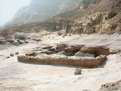
View of the lower part of the site, occupied by remains of the encampment and expedition activity areas.
© Ifao/I. Mohamed Ibrahim.

View of the upper part of the site, where the storage galleries are located.
© Mission d’Ayn Soukhna.

Panel showing rock inscriptions dating to different periods of site occupation from the beginning of the Middle Kingdom. Several other rock inscriptions dating to the Old Kingdom are engraved higher up in the mountain.
© Mission d’Ayn Soukhna.

Hieratic inscription left at the entrance of Gallery 1. The plaster coating had detached from the wall in antiquity and the inscription was scattered in hundreds of fragments.
© Ifao/I. Mohamed Ibrahim.

Remains of a charred sea-going ship dating to the early Middle Kingdom inside Gallery G9.
© Mission d’Ayn Soukhna.

© Mission d’Ayn Soukhna.

Comme au Ouadi el-Jarf, puis plus tard à Mersa Gaouasis, on retrouve à Ayn Soukhna les caractéristiques des ports intermittents égyptiens : un système de galeries-magasins pour entreposer le matériel entre deux expéditions ainsi qu’une zone où se déroulaient les activités des équipes pendant le temps d’occupation du site (habitat, cuisine, stockage provisoire de denrées, administration, ateliers divers).
Ayn Soukhna a été fréquenté tout au long de l’histoire égyptienne, en raison de sa situation privilégiée : le site en effet est proche de la capitale, Memphis, possède une source d’eau potable qui est entourée d’une petite oasis et est situé dans une rade relativement abritée. Les principales phases d’occupation du site datent tout d’abord de l’Ancien Empire (entre Chéphren et Pépy II), puis du début du Moyen Empire (entre Montouhotep IV et Sésostris Ier). La majorité des vestiges fouillés sur le site remontent à ces deux périodes. Mais on trouve aussi une phase plus réduite datant de la fin de la XIIe dynastie, ainsi que des inscriptions rupestres qui attestent le passage d’expéditions sous Amenhotep Ier et Amenhotep III à la XVIIIe dynastie. À l’époque byzantine, des moines coptes installent de petits ermitages sur le site. Un grand panneau rocheux qui surplombe le site constitue un excellent témoin de sa fréquentation, ses inscriptions résumant toute une partie de son histoire.
C’est d’ailleurs ce panneau d’inscriptions rupestres qui a permis le repérage du site archéologique, d’abord par des militaires anglais stationnés sur la côte dans les années 1950 – qui eux aussi ont inscrit leurs noms sur le rocher –, puis par l’égyptologue égyptien Mahmoud Abd el-Raziq, qui lança la mission archéologique en 1999 avec Georges Castel et Pierre Tallet. Après une phase de prospection, la fouille débuta réellement en 2001 et révéla rapidement, dans la partie haute, au pied de la montagne, une série de 10 galeries-magasins, de 15 à 20 m de long, creusées dans le grès à l’Ancien Empire, puis réutilisées durant les phases postérieures de l’occupation du site. On trouve souvent, à leur entrée, des inscriptions officielles commémorant les expéditions égyptiennes de l’Ancien Empire, qui en précisent la date, les objectifs et l’encadrement. L’un des plus beaux exemples est une inscription en hiératique, peinte sur une couche de plâtre posée sur le rocher à l’entrée de la galerie G1, et qui s’était désolidarisée de la paroi dès l’Antiquité. Elle mentionne une expédition datant du règne de Djedkarê-Isési, qui avait pour destination les « Terrasses de la turquoise » – désignation égyptienne de la zone minière du Sud-Sinaï – et était dirigée par le « chef de troupe Sedhotep ». Au début du Moyen Empire, ce type d’inscription commémorative est plus volontiers réalisé sur le panneau rocheux précédemment évoqué, qui domine les galeries. Une inscription de Montouhotep IV mentionne ainsi une expédition comprenant 3 000 hommes. Sous le règne de son successeur Amenemhat Ier, ce sont cette fois-ci 4 000 hommes qui sont engagés dans une mission analogue.
La fouille des galeries a en particulier livré les vestiges exceptionnels de deux bateaux de mer égyptiens datant du début du Moyen Empire ou, de manière plus anecdotique, une petite cache où avaient été oubliés un outil de cuivre, un anneau d’argent et un très beau pendentif en or avec un motif en filigrane.
La fouille de la partie basse du site, entre le piémont montagneux et le littoral, a permis de retrouver les espaces plus volontiers réservés à l’habitat et à la vie quotidienne des équipes qui transitaient par Ayn Soukhna, pendant une période de quelques mois à chaque expédition. En effet, si l’essentiel des troupes partait pour le Sinaï, une petite équipe devait rester sur place pour assurer la connexion avec la vallée du Nil et l’approvisionnement des hommes, ainsi que pour s’occuper du rapatriement des produits de l’expédition. Au début du Moyen Empire d’ailleurs, le premier traitement du minerai de cuivre se fait non pas au Sinaï, directement à proximité des sites d’extraction, comme à l’Ancien Empire, mais sur le site d’Ayn Soukhna.
Enfin, la fouille minutieuse et extensive de ce véritable village intermittent de l’Ancien et du Moyen Empire, permet de comprendre comment les Égyptiens s’adaptaient à leur environnement lorsqu’ils évoluaient en dehors de la vallée du Nil, et de quelle manière étaient organisés leur approvisionnement et leur vie quotidienne. Ils construisent des bâtiments pour la plupart assez frustes, en pierres sèches récupérées sur le site, qu’ils appuient régulièrement sur l’escarpement rocheux marquant la topographie de la partie basse. Ils s’adaptent donc à cet environnement inhabituel et en exploitent efficacement les ressources. Ils venaient avec des ânes – seule bête de charge à laquelle les Égyptiens avaient régulièrement recours à l’Ancien et au Moyen Empire – et du bétail sur pied, ainsi qu’avec des réserves de céréales pour confectionner pain et bière. Ces céréales étaient stockées au début du Moyen Empire dans de grandes jarres fabriquées dans la Vallée et spécifiques au contexte expéditionnaire. Elles portent souvent des marques non-hiéroglyphiques, gravées après cuisson, qui devaient correspondre aux différentes équipes qui composaient l’expédition. Cela servait sans doute à la répartition des denrées par l’administration. Chaque équipe transformait ensuite ses céréales, et l’on a retrouvé sur le site de nombreuses meules, mais aussi des vases à bière et des moules à pain, ainsi que de nombreux fours servant à la cuisson du pain.
Le site d’Ayn Soukhna offre donc un aperçu rare, sur le temps long, de l’organisation et de la vie quotidienne de ces expéditions de plusieurs centaines à plusieurs milliers d’hommes, qui se risquaient, sur les ordres du roi, à la navigation en mer Rouge et à l’exploitation de ses ressources.
Claire Somaglino (Sorbonne Université, UMR 8167)
As at Wadi el-Jarf, then later on Mersa Gawasis, Ayn Soukhna displays the characteristic features of occasionally-used Egyptian harbours: a system of galleries for the storage of material between two expeditions, as well as an area catering for the activities of teams during periods of occupation, including residential, cooking, temporary storage of commodities, administration, and a variety of workshops.
Due to its favourable position Ayn Soukhna was visited throughout the duration of Egyptian history. The site is indeed quite near the capital Memphis. It possesses a source of drinkable water which is surrounded by a little oasis and the harbour is relatively sheltered. The principal phases of occupation at the site date firstly to the Old Kingdom (between Khafra and Pepy II), then to the beginning of the Middle Kingdom (between Montuhotep IV and Sesostris I). The majority of remains recovered at the site date from these two periods. However, one also finds a shorter phase dating to the end of the 12th Dynasty, as well as rock inscriptions that attest to the passing of expeditions under Amenhotep I and Amenhotep III in the 18th Dynasty. In the Byzantine period, Coptic monks set up small hermitages on the site. A great outcrop of rock which overlooks the site provides excellent evidence about those who visited the place. Its inscriptions offer a rich perspective on its history.
It is this expanse of rock inscriptions which enabled the archaeological site to be spotted, firstly by English soldiers stationed along the coast in the 1950s (who also wrote their names on the rock ), then by the Egyptian Egyptologist Mahmoud Abd el-Raziq who, in 1999, embarked on the archaeological mission with Georges Castel and Pierre Tallet. After a period of survey, the excavation began in earnest in 2001. It rapidly revealed, in the upper area at the foot of the mountain, a series of 10 storage galleries, 15 to 20 m long, dug into the sandstone during the Old Kingdom, which were then reused during the later phases of the occupation of the site. At their entrance were frequently found official inscriptions commemorating Egyptian expeditions of the Old Kingdom, which state the date, the expedition’s aims and who was leading it. One of the best examples is a hieratic inscription painted on a layer of plaster on the rock at the entrance of gallery G1, which broke away from the rock in antiquity. It mentions an expedition dating to the reign of Djedkare-Isesi which was heading for the “Terraces of Turquoise” (the Egyptian designation for the mining region of South Sinai) which was led by “army-leader Sedhotep”. At the start of the Middle Kingdom this type of commemorative inscription occurs more often on the rocky panel previously mentioned, which overlooks the galleries. An inscription of Montuhotep IV mentions an expedition which involved 3 000 men. Under the reign of his successor Amenemhat I 4 000 men were engaged in a similar mission on this occasion.
Excavation of the galleries has revealed exceptional remains of two Egyptian sea-going boats which date to the beginning of the Middle Kingdom, as well as, more anecdotally, a small forgotten cache which includes a copper tool, a silver ring and a very beautiful pendant with a filigree motif made of gold.
Excavation of the lower part of the site, between the foot of the mountains and the coast, has enabled us to discover those areas assigned to dwelling area and to the daily life of the contingents who, during each expedition, passed through Ayn Soukhna for a period of several months. In fact, while the main contingent of troops left for Sinai, a small group would remain behind to ensure the link with the Nile Valley and the procurement of supplies for the men, as well as making preparations for the forwarding on of products obtained by the expedition. At the beginning of the Middle Kingdom it is noteworthy to mention that the first processing of the copper as mineral was not conducted in Sinai (and thus close to the extraction sites, as had been done in the Old Kingdom), but was undertaken at Ayn Soukhna.
Finally, the detailed and extensive excavation of this periodically-used village dating to the Old and Middle Kingdoms, enables us to understand how the Egyptians adapted to their environment when they were outside the Nile Valley, as well as how they organised their supply and their daily life. For the most part, they constructed their buildings quite crudely using stones recovered from around the site. A number of these buildings were leaned against the rocky promontory, characteristic of the topography of the lower part of the site. All these elements indicate that they adjusted well to this unusual environment and effectively exploited its resources. They came with donkeys (the only beasts of burden regularly used by the Egyptians in the Old and Middle Kingdoms) and live cattle, as well as grain for making bread and beer. At the beginning of the Middle Kingdom the cereals were stored in jars made in the Valley specifically for such expeditions. Often, they bear non-hieroglyphic marks, carved after firing, which would correspond to the identity of different teams who made up an expedition. Without doubt those marks would be used by the administration for the distribution of commodities. Each team would then process these cereals. On the site numerous grinding-stones have been found, and also beer jars and bread moulds, as well as numerous ovens for baking bread.
The site of Ayn Soukhna offers a rare insight of the organisation and daily life of these expeditions over the long-term. These expeditions, which could comprise several hundreds to several thousands of men, under the orders of the king, ventured into navigating the Red Sea and exploiting its resources.
Claire Somaglino (Sorbonne University, UMR 8167)
تميَّزت العينُ السخنةُ بما تتميز به الموانئ المصريَّة المؤقَّتة، كميناء وادي الچَرْف ثم ميناء وادي مَرْسَى جواسيس؛ حيث يوجد بها مجموعةٌ من مغارات التخزين، تُودعُ بها المُعدَّات خلال الفترات الفاصلة بين حملةٍ استكشافية وأخرى؛ وكذلك منطقةٌ مخصَّصةٌ لنشاط أفراد فرق تلك الحملات خلال فترة إشغال الموقع (مبانٍ سكنية، مطابخ، مخازن مُؤقَّتة للمواد الغذائيَّة، مبانٍ إداريَّة، ورش مختلفة).
توالت الحملاتُ المتجهةُ إلى موقع العين السخنة، طوال عصور التاريخ المصريّ؛ نظرًا لموقعها المتميز: فهي تقعُ بالقرب من العاصمة منف وتتمتعُ بموردِ مياهٍ صالحةٍ للشرب تحيطُ به واحةٌ صغيرة، كما يقع على خليجٍ آمنٍ نسبيًّا. وشهد الموقعُ أهم فترات إشغاله في عصر الدولة القديمة (في الفترة ما بين عصر الملك خفرع والملك بيبي الثاني)، ثم الفترة من بداية عصر الدولة الوسطى (بدءًا من عهد الملك منتوحتب الرابع وحتى عهد الملك سيزوستريس الأول). فمعظم البقايا الأثريَّة التي تمَّ التنقيب بها في الموقع ترجع إلى هاتيْن الفترتين. كما أن هناك شواهد أقل عددًا تعود إلى نهاية عصر الأسرة الثانيةَ عشرةَ، كما عُثِر على نقوشٍ صخريَّةٍ بالموقع تدلُّ على مرور حملاتٍ في عهد كُلٍّ من الملكين: أمنحتب الأول وأمنحتب الثالث من الأسرة الثامنة عشرة. وفي العصر البيزنطي، أقام بعضُ الرُّهبانِ الأقباط صوامع صغيرة بالموقع. وتمثلُ اللوحةُ الصخريَّةُ الضخمةُ المُطلَّةُ على موقع العين السخنة خيرَ شاهدٍ على أن المصريين كانوا يتردَّدون عليه، وتلخص نقوشه جُزءًا مُهمًّا من تاريخ الموقع.
وقد كانت تلك اللوحةُ ذاتُ النقوشِ الصخريَّة وراء اكتشاف الموقع الأثريّ: ففي عام 1950 عَثر عليها - أولًا - مجموعةٌ من الجنود البريطانيِّين المتمركزين على الساحل، والذين قاموا بدورهم بنقش أسمائهم على الصخرة، ثم اكتشفها عالم الآثار المصري محمود عبدالرازق، الذي أطلق عام 1999 بَعْثةً أثريَّةً بالتعاون مع كُلٍّ من ﭼورﭺ كاستيل وپيير تاليه. وبعد مرحلةٍ استكشافيَّة، بدأت في عام 2001 أعمالُ التنقيب الفعليَّة والتي سرعان ما كشفت عن وجودِ عشرةِ أروقةٍ للتخزين بالجزء العلوي من الموقع عند سفح الجبل، يتراوحُ طول كل منها من 15 إلى 20 مترًا نُحتت في الأحجار الرمليَّة في عهد الدولة القديمة، ثم أُعيد استخدامها خلال المراحل اللاحقة من إشغال الموقع. غالبًا ما نجدُ عند مدخلِ تلك االمغاراتِ، نقوشًا رسميَّةً تُسجِّلُ ذكرى وصول الحملات المصريَّة في عصر الدولة المصريَّة القديمة؛ إذ تشيرُ تلك النقوشُ إلى تاريخِ الحملة وأهدافها وقياداتها. ومن أروع النقوش التي اُكتُشفت بالموقع نقشٌ باللغة الهيراطيقيَّة مرسومٌ على طبقةٍ من الجصِّ تغطي الصخرة الموجودة في مدخل الرواق 1 G، إلا أنَّ تلك الطبقةَ قد انفصلت عن الجدار منذ العصور القديمة. تشيرُ تلك النقوش إلى وصولِ حملةٍ إلى الموقع في عهد الملك جد-كا-رع أسيس كانت متجهةً إلى «أرض الفيروز»، وهو مُسمًّى أطلقه المصريون على منطقةِ التعدينِ الواقعةِ في جنوب سيناء، وكانت الحملة تحت قيادة «القائد سد حتب». أما النقوش التذكاريَّة السابق ذِكْرُها والتي تعود إلى عصر الدولة الوسطى، فأغلبُها مُسجَّلٌ على تلك اللَّوْحةِ الصخريَّةِ الموجودة أعلى المغارات. فعلى سبيل المثال، عُثِر على نقشٍ صخرىٍّ سُجِّل في عهد الملك أمنحتب الرابع، ويشيرُ إلى وصولِ حملةٍ تضمُّ ما لا يقلُّ عن 3000 شخصٍ، ثم حملة مماثلةٍ في عهد الملك أمنمحات الأول، قوامُها 4000 آلاف فردٍ.
ويُعدُّ أهمُّ ما كشفت عنه أعمال التنقيب في تلك المغارات، هو أجزاء من حطام سفينتيْن بحريَّتيْن مصريَّتيْن يرجع تاريخُهما إلى أوائل عصر الدولة الوسطى؛ كما تم كذلك اكتشافُ خبيئةٍ صغيرةٍ عُثِر فيها على بعض الأدوات المنسيَّة وعلى قلادةٍ ذهبيَّةٍ رائعةِ الجمالِ تزيِّنُها زخارفُ ذهبيَّة.
وأسفر التنقيب بالجزء السُّفلِي من الموقع، في المساحة ما بين السَّهْلِ الجبليّ والساحل عن العثور على منطقةٍ كانت مُخصَّصةً لسكن وأنشطة الحياة اليوميَّة لأفراد الحملات، الذين كانوا يقيمون بها لعدة أشهر في كل حملة. ففي الواقع وعلى الرغم من أن معظم أفراد الحملة كانوا يتوجهون إلى أرض سيناء، فإن عددًا قليلًا منهم كان يمكثُ في العينِ السُّخْنَة كي يلعب دورَ حلقةِ الاتصالِ بالوادي، وتأمين الإمدادات والمُؤَن لرجال الحملة، كما كانت تُسند إلي هؤلاء مسئولية إيصال ما أنتجته الحملة إلى الوادي. هذا بالإضافة إلى أن عمليَّة المعالجة الأوليَّة للنُّحاس كانت تتمُّ في موقع العين السخنة في بداية عصر الدولة الوسطى، خلافًا لعصرِ الدولةِ القديمةِ حيثُ كانت تتمُّ هذه العملية في سيناء بالقرب من موقع استخراج المعدن.
وأخيرًا، فقد ساعدت أعمالُ التنقيبِ الدقيقةُ والمُوسَّعة لذلك القطاع، الذي يُعدُّ قريةً كاملةً مُؤقَّتةً بالمعنى الحقيقيّ للكلمة في عصر الدولتين القديمة والوسطى، على فهم كيفيَّة تأقلُم المصريين مع البيئة المحيطة بهم في فترات تواجدهم خارج وادي النيل وما هي الطريقة التي كانت تنظم المُؤَن والحياة اليوميَّة. فقد كانوا يُشيِّدون المبانى - التي كانت في معظمها بسيطة نوعًا - من الأحجار الجافَّة التي تم جمعُها من الموقع وتستند بشكلٍ منتظمٍ على المُنحدَر الصخريّ الذي يميز طُبُوغرافية الجزء السفلي من الموقع. فقد كانوا إذن يتكيَّفون مع تلك البيئة المختلفة بالنسبة لهم ويستغلُّون مواردها بشكل جيد. كما كان المصريون يصطحبون الحُمُر إلى موقع العين السخنة حيث كان الحمار، هو الحيوان الوحيد الذي استخدمه المصريون في ظل الدولتين القديمة والوسطى لحمل ونقل المتاع؛ كما كانوا يصطحبون أيضًا الماشيةَ ويجلبون الحبوبَ لصناعةِ الخبزِ وشرابِ الشعير. وكانت الحبوب تُخزَّن إبَّان اوائل عصر الدولة الوسطى في جِرارٍ كبيرةٍ صُنعت في الوادي خِصِّيصًا للتخزين خلال فترة الحملات. تحمل تلك الجرارُ علاماتٍ بكتابة غير الهيروغليفيَّة نُقِشت بعد الخروج من الفرن، يُرجَّح أنها كانت تمثل الفرق المختلفة المُكوِّنة للحملة؛ مما يساعد الإدارةَ على توزيع حصص الأغذية، ثم يعمل كل فريق على تجهيز الغِلَال الخاصة به؛ حيث عثرنا في الموقع على الكثير من رَحَى الحبوب؛ وكذلك جرار حفظ شراب الشَّعِير، وقوالب صنع الخبز والكثير من الأفران.
إن موقعَ العينِ السُّخْنةِ يعطينا لمحةً نادرةً عن التنظيمِ ونمطِ الحياةِ خلالَ تلك الحملاتِ التي قَدِمت إلى الموقع، والتي كانت تتألَّفُ من مئاتِ وحتى آلافِ الأشخاص الذين كانوا يُخاطرون بالملاحةِ في البحر الأحمر واستغلالِ مواردهِ تنفيذًا لأوامر من الملك.
كلير سوماجلينو (جامعة السوربون، UMR 8167)
Bibliographie
- M. Abd el-Raziq, G. Castel, P. Tallet, V. Ghica, Les inscriptions d’Ayn Soukhna, MIFAO 122, Le Caire, 2002.
- M. Abd el-Raziq, G. Castel, P. Tallet, P. Fluzin, Ayn Soukhna. II. Les ateliers métallurgiques du Moyen Empire, FIFAO 66, Le Caire, 2011.
- M. Abd el-Raziq, G. Castel, P. Tallet ; V. Le Provost, G. Marouard (coll.), Ayn Soukhna. III. Le complexe des galeries-magasins : rapport archéologique, FIFAO 74, Le Caire, 2016.
- G. Castel, P. Tallet (éd.), Ayn Soukhna. IV. Études du matériel des galeries-magasins, sous presse.
- Page web ʿAyn Soukhna archivée (2012)