Ouadi Araba
| 10.34816/ifao.6888-ce2f | |
| 257479309 | |
| Missions Ifao depuis | 2008 |
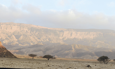
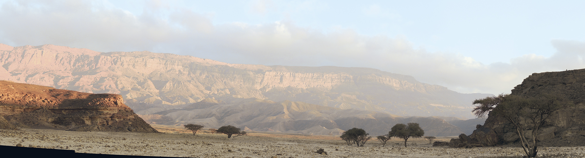
General view of Wadi Araba.
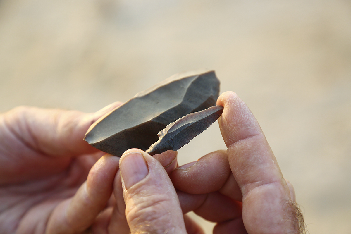
PPNB arrowhead.
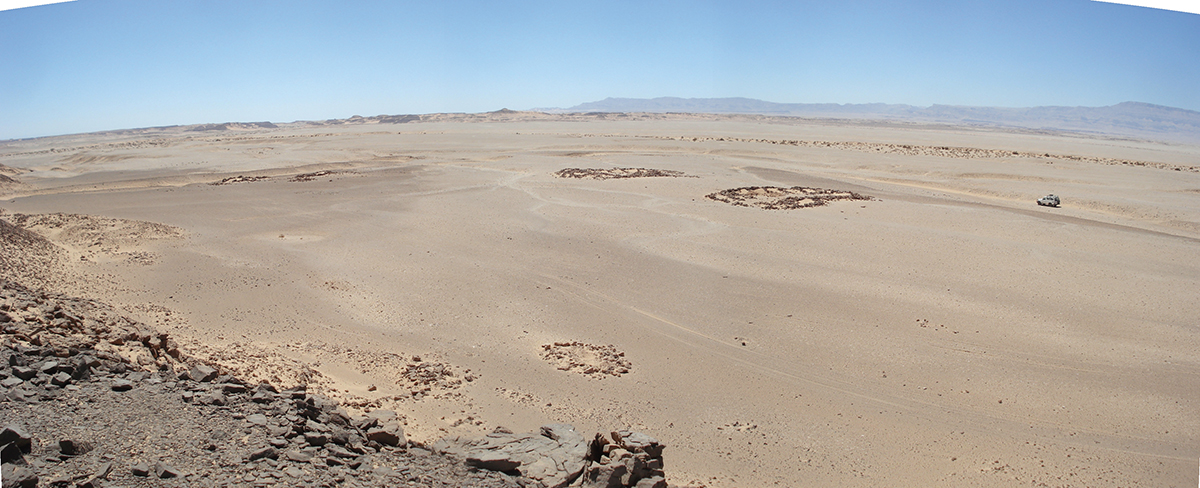
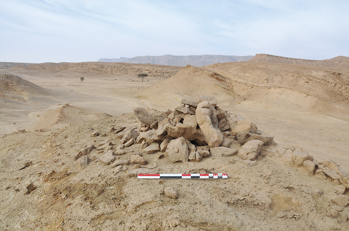
General view of a camp of the Old Kingdom, 4th Dynasty.
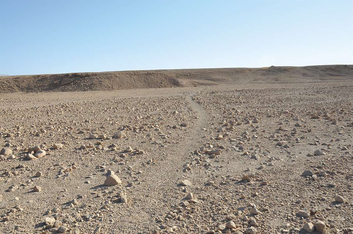
Pharaonic track north of Wadi Araba. A track marker is visible on the terrace in the background.
© Ifao/Y. Tristant.
© Ifao/Y. Tristant.
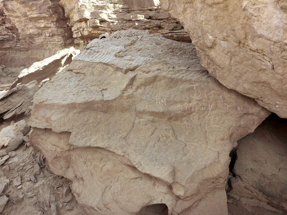
Rock art panel in the Wadi Araba.
Le Ouadi Araba fait partie des espaces désertiques de l’Égypte encore méconnus du point de vue archéologique. Visitée par les géologues et les savants depuis le XIXe s. – Guy Brunton, Georg August Schweinfurth, Antonio Bey Figari, René Fourtau, John Ball –, la région n’avait toutefois pas encore été explorée systématiquement et restait un territoire presque totalement inconnu. Les documents ponctuels que l’on peut réunir sur cette voie de communication – la seule qui relie la Moyenne Égypte au golfe de Suez – montrent pourtant le potentiel archéologique et historique unique du Ouadi Araba. Dans le désert oriental, espace de circulation exploité depuis la Préhistoire pour ses ressources en pierre et en minerais de cuivre ou d’or, la prospection et l’inventaire archéologique de cette région offrent des problématiques inédites sur l’étude des pistes du désert entre la vallée du Nil et le Sinaï. John Gardner Wilkinson mentionne en 1832 les ermitages coptes du Galala et une mine de cuivre d’époque pharaonique. Cette dernière découverte a été reprise par George W. Welsh Murray dans un article publié en 1951. C’est à la même époque qu’un petit groupe d’archéologues amateurs français entreprend une exploration des sites du Ouadi Araba. La crise du canal de Suez en 1956 a mis un terme définitif à leur recherche. Occupée par les militaires égyptiens et minée pour éviter toute intrusion depuis la mer Rouge, la région n’a depuis fait l’objet d’aucune nouvelle étude. Depuis 2008, le programme de recherche mené par l’Institut français d’archéologie orientale (Ifao) a pour but d’explorer le Ouadi Araba et de réaliser une carte archéologique de cet espace encore inconnu.
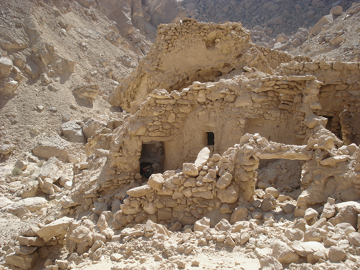
Plus de 200 sites ou faits archéologiques ont été repérés et étudiés entre 2008 et 2015 : plusieurs sont des sites préhistoriques et prédynastiques, des campements miniers de l’Ancien et du Moyen Empire avec une piste les reliant, des gravures rupestres, des habitats et cimetières romains/byzantins, ainsi que des ermitages coptes. Les observations effectuées durant les missions successives montrent que cette vallée aride a été un espace de passage depuis la Préhistoire la plus ancienne. Les principales découvertes concernent la présence de sites paléolithiques et néolithiques (Pre-Pottery Neolithic B, PPNB) ; de campements, mines et pistes d’époque pharaonique (Ancien et Moyen Empire) ; ainsi que d’une occupation plus tardive de la région à l’époque byzantine, associée aux activités minières (calcite) et au développement du monastère Saint-Antoine (ermitages coptes). Pour les périodes les plus anciennes, de nombreux gisements de la fin de la Préhistoire ont pu être identifiés sur les basses terrasses du Ouadi Araba et au pied du Galala-nord. Il s’agit de concentrations de matériel en silex épars, sans association avec de quelconques structures visibles. Le Prédynastique se limite quant à lui à quelques gravures rupestres, ibex et peut-être scènes de chasse, dont l’attribution à cette période doit encore être confirmée. À une vingtaine de kilomètres au nord-ouest du monastère Saint-Antoine, sur le site de Bi’r Buerat, des pièces lithiques sur lames épaisses et des éclats de pièces bifaciales suggèrent la présence d’industries Nagada III ou Ancien Empire. Cependant la découverte la plus exceptionnelle, qui plus est d’influence orientale, concerne une période encore trop mal connue de la préhistoire égyptienne. La découverte sur ce même site d’une industrie totalement spécifique, apparentée aux cultures précéramiques du Levant, relance la question du PPNB (IXe-VIIIe millénaires av. J.-C.) en Égypte et la part des influences orientales dans le développement du Néolithique égyptien. La période pharaonique est représentée par des sites miniers de l’Ancien et du Moyen Empire reliés entre eux et aux sources d’eau du Galala-nord par une piste encore nettement visible dans le paysage. Les installations en pierre, qui ont tout aussi bien pu servir de cabanes ou de lieux de stockage pour le matériel, les galeries d’extraction des veines de malachite, le mobilier associé comprenant des jarres de stockage et des outils (pics à gorge, enclumes, marteaux, etc.) témoignent des expéditions organisées dans le désert oriental pour rapporter du minerai. Pour les époques plus récentes, des sites romains/byzantins sont liés à l’exploitation de la calcite dans le massif du Galala-nord et du Galala-sud. Le Ouadi Araba compte également plusieurs ermitages coptes liés à la présence du monastère Saint-Antoine.
Yann Tristant (Macquarie University (Sydney))
Wadi Araba forms part of the desert areas of Egypt which are little known from an archaeological point of view. Visited by geologists and scholars from the 19th century (including Guy Brunton, Georg August Schweinfurth, Antonio Bey Figari, René Fourtau and John Ball), the region has never been systematically explored and remains an area which is nearly completely unknown. Nevertheless, rare documents assembled about this communication route (the only one which links Middle Egypt to the Gulf of Suez) indicate the archaeological and historical potential of Wadi Araba. Communication routes in the Eastern Desert have been used since prehistory to exploit its resources of stone and the minerals copper and gold. The survey and archaeological inventory of this region provides fresh research issues on the study of desert tracks between the Nile and Sinai. In 1832 John Gardiner Wilkinson mentioned Coptic hermitages of Galala and a Pharaonic period copper mine. This latter discovery was taken up by George W.W. Murray in an article published in 1951. At this time a small group of French amateur archaeologists undertook investigation of Wadi Araba sites. The Suez Canal crisis in 1956 put a decisive end to their research. Occupied by the Egyptian military and laid minefields to avoid any invasion from the Red Sea, the region has not since been the subject of any new study. Since 2008, the research project led by the French Institute for Oriental Archaeology (IFAO) has aimed to explore Wadi Araba and produce an archaeological map of this still unknown area.
Between 2008 and 2018, more than 200 sites or archaeological features have been located and studied. Several are Prehistoric and Predynastic sites, mining camps dating to the Old and Middle Kingdoms with a connecting track between them, rock inscriptions, settlements and Roman/Byzantine cemeteries as well as Coptic hermitages. The observations made during successive seasons show that this arid valley had been a thoroughfare from most ancient times in Prehistory. The main discoveries relate to the presence of Palaeolithic and Neolithic sites (Pre-Pottery Neolithic B, PPNB), encampments, mines and tracks of the Pharaonic era (Old and Middle Kingdoms), as well as the last occupation of the region during the Byzantine period, which was associated with the mining activities (particularly of calcite) and the development of the monastery of Saint Anthony with Coptic hermitages.
For the most ancient periods, numerous deposits dating to the end of Prehistory have been identified on the lowest terraces of Wadi Araba and at the foothills of the northern Galala. These consist of concentrations of scattered flint without association with any visible structures. Evidence from the Predynastic period is limited to some rock inscriptions showing ibex and perhaps hunting scenes, though their dating to this period is still to be confirmed. Twenty kilometres to the monastery of Saint Anthony, at the site of Bi’r Buerat, lithic fragments with thick blades and bifacial pieces suggest the presence of industries dating to Naqada III or the Old Kingdom. However, the most exceptional discovery, indicating influences from the East, relate to a period in Egyptian history which is still too poorly understood. The discovery at this site in Egypt of a specialised industry which appears in pre-ceramic cultures of the Levant during the PPNB Neolithic (9th to 8th millennium) highlights eastern influences on the development of Neolithic Egypt.
The Pharaonic period is represented by mining sites of the Old and Middle Kingdoms and by water sources of the northern Galala, which are linked by a track which is still clearly visible in the landscape. The stone structures, which could have served as huts or storage places for goods, galleries created during the extraction of veins of malachite, associated items including storage jars and tools (picks, anvils, hammers etc.) all testify to the presence of organised expeditions in the Eastern Desert to bring back ore.
For more recent times, Roman and Byzantine sites are associated with the exploitation of calcite in the northern and southern Galala massif. In addition, Wadi Araba has several Coptic hermitages which are linked to the monastery of Saint Anthony.
Yann Tristant (Macquarie University, Sydney)
وادي عَرَبةَ من المواقع الصحراويَّة المصريَّة التي لا تزالُ مجهولة أثرياً. ورغم أن الـﭼيولوﭼيِّين والعلماء، مثل جي برونتون، وجيورج أوجوست شڤاينفورت، وأنطونيو باي فيجاري، ورينيه فورتو، وﭼـون بول، جميعُهم زاروا المنطقةَ منذ بدايات القرن التاسع عشر، إلا إنَّه لم يتمَّ استكشافُها بشكلٍ منهجيّ وظلَّت منطقةً شبهَ مجهولة. هذا على الرغم من أن الوثائقَ المتفرقة التي يمكن جمعُها حول هذا الطريقِ الوحيد الذي يصل بين مصر الوسطى وخليج السويس، تشيرُ إلى أهميَّة المكنونِ الأثريّ والتاريخيّ المُتفرِّدِ لوادي عَرَبَة. هذا الوادي يُمثلُ مكانًا للعبورِ في الصحراء الشرقيَّة اُستُخدم منذ ما قبلِ التاريخ نظرًا لمواردهِ من الحجارةِ والمعادنِ مثل النُّحاس أو الذَّهب، فالمسحُ والحصرُ الأثريّ لهذه المنطقةِ من شأنه طرحُ إشكاليَّاتٍ جديدةٍ فيما يخصُّ دراسةِ ممرَّاتِ الصحراءِ بين وادي النيل وسَيْنَاء. كان ﭼـون جاردنر ويلكنسون قد أشار - في 1832 - إلى وجودِ الصوامع القِبْطيَّة في جبلِ الجلالة، ومنجم نُحاسٍ من العصر الفرعونيّ. وأعاد ﭼورﭺ ويلش موراي ذِكْرَ هذا الاكتشافِ الأخير في مقالٍ نُشر عام 1951. وفي الفترة نفسها، بدأت مجموعةٌ صغيرةٌ من الأثريِّين الفرنسيِّين الهُواة في استكشافِ مواقعِ وادي عَرَبَة غير أن أزمةَ قناةِ السُّويْسِ عام 1956 وضعت حدًّا نهائيًّا لأبحاثهم. وتمركزَ الجيشُ المصريُّ في المنطقةِ وزُرعت الألغامُ بها لتجنُّب أىّ تسلُّل عن طريق البحر الأحمر، ولم تتناول أيَّةُ دراسةٍ جديدةٍ المنطقة. منذ عام 2008، بدأ البرنامجُ البحثيُّ الذي يقودُه المعهد الفرنسي للآثار الشرقية، والذي يهدفُ إلى استكشافِ وادي عَرَبَة، ورسمِ خريطةٍ أثريَّةٍ لهذا المكانِ الذي لا يزالُ مجهولًا.
وقد تم تحديدُ أكثرَ من 200 موقعٍ أو حدثٍ أثريّ، ودراستُها في الفترة ما بين 2008 و2015، الكثيرُ منها مواقعُ تعودُ إلى فترةِ ما قبل التاريخ، وعصرِ ما قبل الأُسْرَات، ومُخيَّمات لعمال المناجم من الدولتين القديمة والحديثة، - هناك دربٌ يربطُ فيما بينها -، ومنحوتات صخريَّة، وأبنية سكنيَّة، ومقابر رومانيَّة/بيزنطيَّة وكذلك صوامع قِبْطيَّة. والملاحظاتُ التي تمت خلالَ البعثات المتتالية تُبيِّن أن هذا السهلَ الجافَّ كان مكانًا للمرورِ منذ أقدمِ عصورِ ما قبل التاريخ. والاكتشافاتُ الأساسيَّةُ تتعلقُ بوجودِ مواقعَ من العصرين الحَجَريّ القديم، والحجريّ الحديث ما قبل الفَخَّار؛ وكذلك مُخيَّمات، ومناجم، ودروب من العصر الفرعونيّ (الدولتان القديمة والحديثة)، وإشغال أكثر تأخرًا يعود إلى العصر البيزنطيّ مرتبط بالأنشطة التعدينية (الكَالسَيِتْ)، وفترة ازدهار دير الأنبا أنطونيوس (الصَّوامِع القِبْطيَّة).
بالنسبة إلى الحِقبِ الأكثر قِدَمًا، تمَّ التعرُّفُ على الكثير من الطبقاتِ التي تعودُ للعصرين الحجريّ القديم والحديث، عُثر عليها أسفل مُنْحدَرِ وادي عَرَبَة وسفح جبل الجلالة، وهي عبارةٌ عن تركُّزات لأدوات متناثرةٍ من الظَّرَان، غير مرتبطةٍ بأي بناء ظاهر. أما بالنسبة إلى المواد المُتعلِّقة بعصر ما قبل الأُسْرَات، فهي تنحصرُ في بعضِ النُّقوشِ التي تصورُ حيوان الوَعْل، أو مشاهدَ صيدٍ، ومن المفترَض التأكُّد من انتمائها لتلك الحقبةِ التاريخيَّة. وعلى بُعْدِ قرابة 20 كيلومترًا، شمال غرب دير أنبا أنطونيوس، في موقع بئر بوقريط، عُثرَ على قطعٍ حجريَّةٍ على شفراتٍ سميكة، وشظايا قطعٍ ذات وجهين تشيرُ إلى وجود أنشطةٍ تعودُ إلى فترة النَّقَادَةِ الثالثةِ أو الدولة القديمة. ومع ذلك، فإن الاكتشافَ الأكثر تفرُّدًا، يرجعُ إلى فترةٍ غيرِ معروفةٍ بشكلٍ مُحدَّد من عصر ما قبل التاريخ في مصر، أى العصر الحجريّ الحديث: فاكتشاف نشاطٍ ذي علاقةٍ بثقافاتِ العصرِ النيوليتىّ السابق للفخَّارِ في بلاد الشام يطرحُ من جديد مسألةَ العصرِ الحجريّ الحديث ما قبل الفَخَّار (8700 إلى 7000 ق. م.) في مصر، ومدى التأثير الشرقيّ في تطوير العصرِ الحجريّ الحديث المصريّ.
أما الحقبةُ الفرعونيَّة، فهي مُمثَّلةٌ في مواقع مناجم من عصر الدولة الوسطى والدولة القديمة يصلُ فيما بينها وكذلك بينها وبين عيون المياه - بجبل الجلالة الشماليّ - دربٌ لا يزالُ ظاهرًا بشكلٍ واضحٍ على السطح. كما تشهد بناياتٌ حجريَّةٌ، من الممكن أن تكون اُستُخدِمت كأكواخٍ أو أماكنَ تخزينٍ للمواد، وسراديبَ استخراجِ عروقِ المالاكيت والأدوات اللازمة لتلك العمليَّة، وتشمل جِرارَ تخزينٍ وأدواتٍ (مَعاوِل - مَطارِق - سَنَادِين)، جميعُها تشهدُ بوجودِ حملاتٍ استكشافية نُظِّمَت إلى الصحراء الشرقيَّة لجلب المعادن.
أما بالنسبة إلى الحِقبِ الأكثرِ حداثةً، فهناك مواقعُ رومانيَّةٌ-بيزنطيَّةٌ مرتبطةٌ باستغلال الكالسيت في هضبةِ الجلالةِ الشماليَّة والجنوبيَّة. كما يضمُّ وادي عَربَةَ كذلك عدَّةَ صوامع قِبْطيَّة مرتبطة بوجود دير الأنبا أنطونيوس.
يان تريستان (جامعة ماكواري - سيدني)
Bibliographie
- Y. Tristant, « Le désert Oriental durant la préhistoire. Bref aperçu des travaux récents menés dans le Wâdî ‘Araba », Archéo-Nil 20, 2010, p. 51-61.
- V. Ghica, Y. Tristant, « Biˀr Biḫīt: Preliminary Report on the 2012 Field Season », BACE 23, 2012, p. 7-24.
- Y. Tristant, « How to Fill in the Gaps? New Perspectives on Exchanges between Egypt and the Near East. During the Early Neolithic Period », in P. Tallet, E.S. Mahfouz (éd.), The Red Sea in Pharaonic Times. Recent Discoveries along the Red Sea Coast. Proceedings of the Colloquium held in Cairo/Ayn Soukhna, 11th-12th January 2009, BiEtud 155, Le Caire, 2012, p. 145-158.
- Y. Tristant, « Nouvelles découvertes dans le désert Oriental. Le Wâdî ‘Araba de la préhistoire à l’époque copte », BSFE 182, 2012, p. 33-53.
- Y. Tristant, « Wâdî ‘Araba (Eastern Desert) », in L. Donovan, S. Binder (éd.), Tombs, Trowels and Treasures. The first 40 years of Egyptology at Macquarie University, ACE-Stud. 12, Oxford, 2018, p. 224-231.
- Page web Wâdî ʿAraba archivée (2013)