Hatnoub
| 10.34816/ifao.9148-43e3 | |
| 231171528 | |
| Missions Ifao depuis | 2012 |
Les carrières de travertin égyptien de HatnoubOpération de terrain 17134
Responsable(s)
![]() Yannis Gourdon (CNRS, UMR 5189 HiSoMA)
Yannis Gourdon (CNRS, UMR 5189 HiSoMA)
![]() Roland Enmarch (Université de Liverpool)
Roland Enmarch (Université de Liverpool)
Partenaires
![]() 🔗 Institut français d’archéologie orientale (IFAO)
🔗 Institut français d’archéologie orientale (IFAO)
🔗 Université de Liverpool
🔗 The KU Leuven Dayr al-Barsha project
🔗 Musée des Beaux-Arts de Lyon (MBA-Lyon)
🔗 Garstang Museum of Archaeology
![]() 🔗 Neues Museum
🔗 Neues Museum
Cofinancements
🔗 Université de Liverpool
🔗 Fonds Khéops pour l’archéologie
![]() 🔗 Egypt Exploration Society (EES)
🔗 Egypt Exploration Society (EES)
Dates des travaux
août - septembre
Rapports de fouilles dans le BAEFE
2021 : 10.4000/baefe.6305
2019 : 10.4000/baefe.1028
➣ Site(s) de la mission
http://fondskheopsarcheologie.fr/missions-recherche-archeologique-hatnoub.php
Participants en 2024
| Yannis Gourdon | égyptologue, maître de conférences | CNRS, UMR 5189 HiSoMA | |
| Roland Enmarch | égyptologue, maître de conférences | Université de Liverpool | |
| Hélène Bouillon | égyptologue, conservateur du patrimoine | ||
| Jean-Jacques Delannoy | géomorphologue, professeur des universités | université Savoie-Mont-Blanc (Le Bourget du Lac) | |
| Dominique Farout | égyptologue | ||
| Liz Jones | topographe | University College of London | |
| Olivier Lavigne | tailleur de pierre archéologue | ||
| Hannah Pethen | égyptologue, doctorant | University of Liverpool | |
| Andrea Pillon | égyptologue | ||
| Sépideh Qahéri-Paquette | égyptologue, ATER | Collège de France, chaire de civilisation pharaonique | |
| Thomas Sagory | archéologue | Ministère de la culture et de la communication | |
| Benoit Touchard | photographe, indépendant |
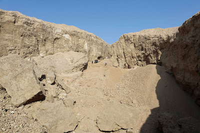
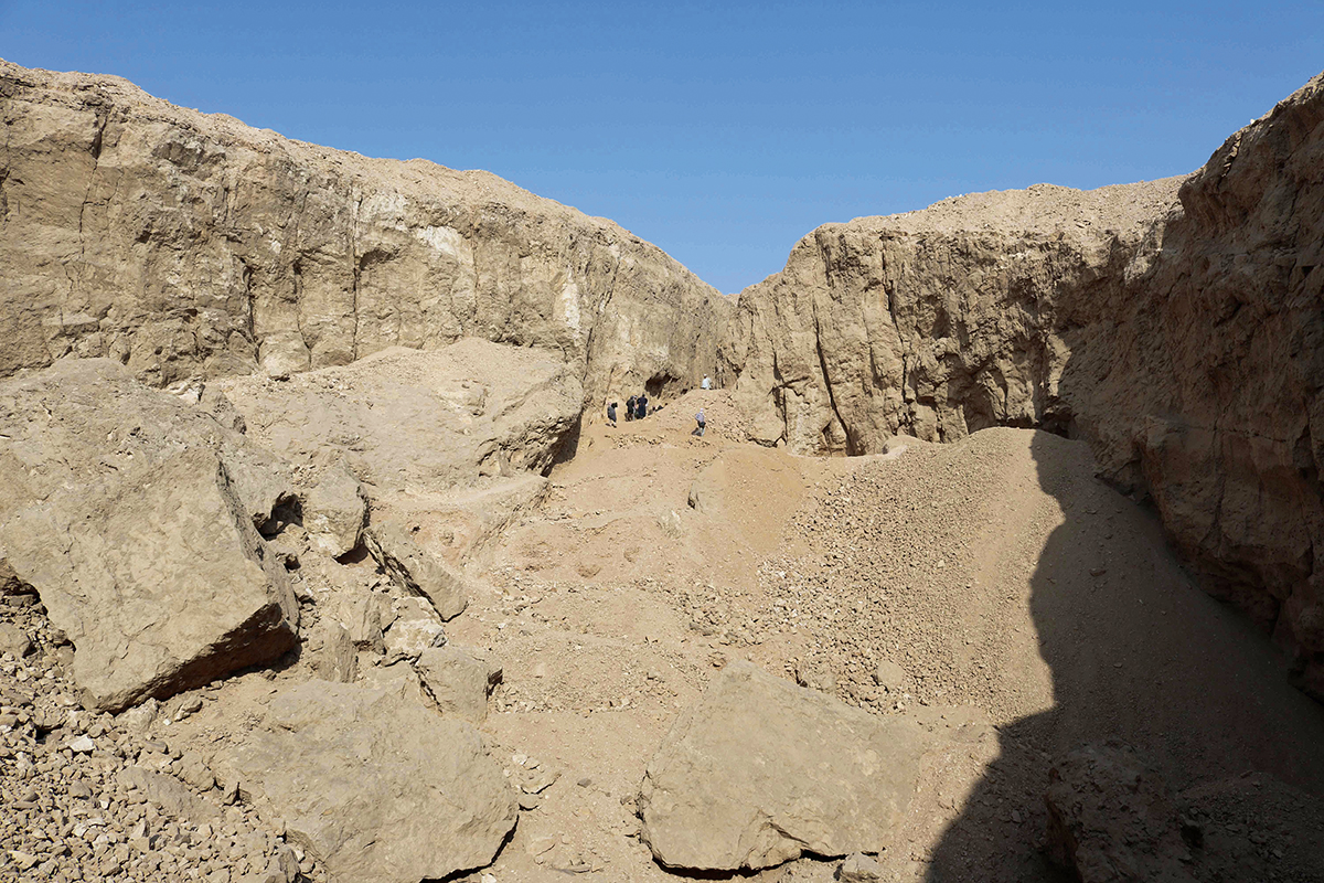
Aerial view of P Quarry.

View of the open-cast oval pit of the P Quarry.
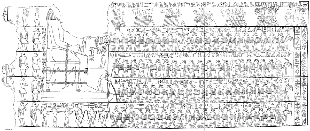
Scene of the transport of the colossus of Djehutyhotep.
One of the new inscriptions of P Quarry after processing with DStretch software.

View of the hauling system of the blocks of P Quarry.

© Ifao/O. Lavigne.
Hatnoub, un site prestigieux dans la documentation pharaonique
Utilisé, dès l’époque prédynastique, dans la production artisanale comme dans l’architecture, l’albâtre calcite a très tôt été associé à la région de Hatnoub. Parmi les milliers de vases en pierre trouvés dans les galeries souterraines de la pyramide à degrés de Djéser, plus d’une centaine réalisée en albâtre porte des inscriptions mentionnant Hatnoub, ce qui indique que ce site fut exploité au plus tard au début de la IIIe dynastie.
Avant la découverte de la carrière P et de ses inscriptions, l’autobiographie d’Ouni – un très haut fonctionnaire de la VIe dynastie – était la plus ancienne source relatant une expédition conduite à Hatnoub, sous le règne de Mérenrê Ier. Ce texte, qui présente Hatnoub comme la région d’extraction de l’albâtre, ne fournit aucune indication quant à la localisation exacte de ce site. C’est grâce à la célèbre représentation du transport du colosse en albâtre et au texte qui l’accompagne dans la tombe du gouverneur Djéhoutyhotep à Deir el-Bercheh que l’on put, pour la première fois, établir un lien entre Hatnoub et le nome de la Hase. Ce récit d’expédition laissait entendre que les carrières se situaient dans la région de l’antique Hermopolis, capitale du nome de la Hase.
Cette hypothèse fut vérifiée le 22 décembre 1891, date à laquelle la carrière P de Hatnoub et ses inscriptions rupestres furent découvertes par l’égyptologue Percy Newberry et son jeune dessinateur Howard Carter, à 18 km au sud-est de l’ancienne Tell el-Amarna.
Les travaux épigraphiques et archéologiques à Hatnoub
Dès 1894, Marcus Blackden et George Fraser publièrent 32 de ces inscriptions. Mais c’est véritablement le travail réalisé par Georg Möller à l’été 1907 qui révéla la richesse épigraphique et historique de ce site qui comptait alors 61 inscriptions rupestres et stèles. Celles-ci furent publiées, après sa mort prématurée, par Ruldolph Anthes en 1928.
Il fallut attendre une soixantaine d’années pour que l’on s’intéresse à nouveau à Hatnoub. Entre 1985 et 1994, Ian Shaw (University of Liverpool) a mené les premiers travaux archéologiques dans la région ; il a ainsi prospecté et documenté les nombreuses structures environnant la carrière P.
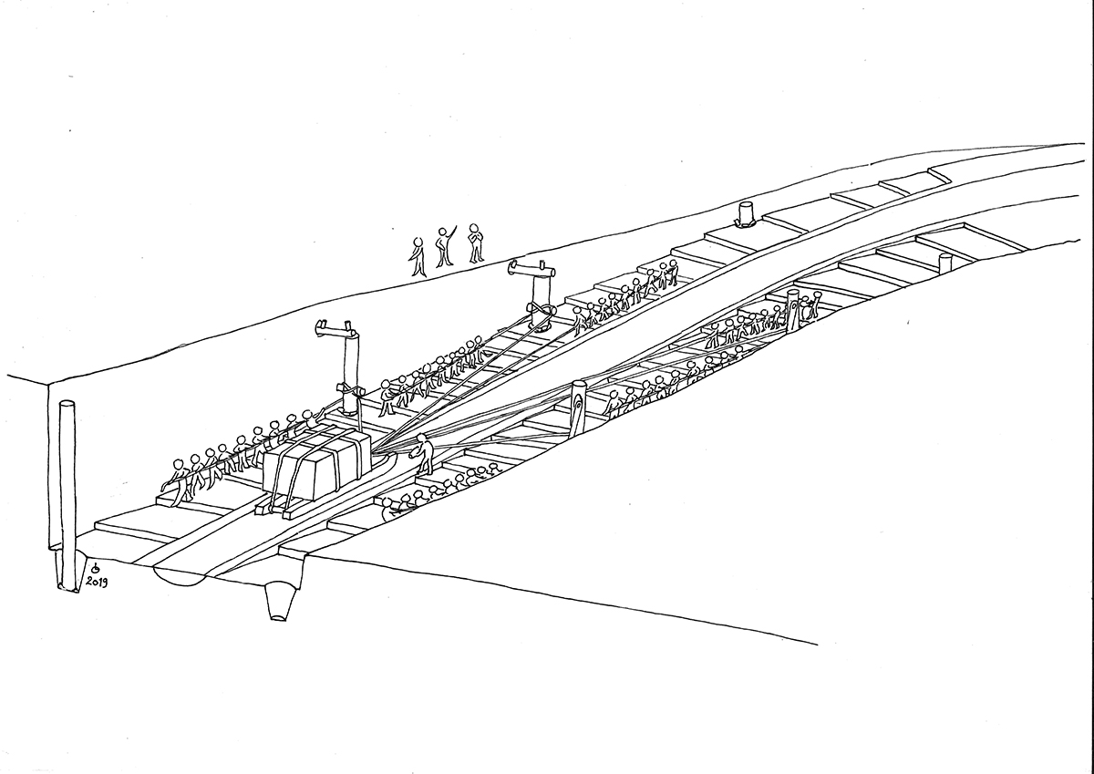
Fondée en 2012 et codirigée par Yannis Gourdon (Ifao) et Roland Enmarch (University of Liverpool), la mission épigraphique et topographique de Hatnoub visait en premier lieu à republier ces textes selon les normes épigraphiques en vigueur. Après 7 saisons dans la carrière P et sur le plateau de Hatnoub, cette mission est aujourd’hui un chantier archéologique à part entière, qui a déjà donné des résultats remarquables. En plus d’apporter des corrections et des ajouts substantiels aux textes déjà connus, nous avons considérablement augmenté le nombre d’inscriptions, qui est passé de 61 à 160. Nos fouilles ont également mis au jour des niveaux d’ateliers du Nouvel Empire, et nous avons découvert un système de halage de blocs exceptionnel comprenant notamment une rampe ascendante inclinée en certains endroits jusqu’à 22 % et qui pourrait être un jalon décisif pour comprendre la construction des grandes pyramides de Giza.
La carrière P de Hatnoub et ses inscriptions
La carrière P est au cœur d’un vaste réseau de voies antiques, de sentiers, et de pistes reliant à la fois les carrières entre elles et les carrières au Nil, le lieu d’embarquement des blocs d’albâtre pour des destinations variées. Près d’un millier de structures jalonnent ces voies et les abords de la carrière P. Ces installations très diverses vont du simple marquage topographique par des cairns à des abris semi-circulaires, des ateliers de taille de la pierre jusqu’à des structures cultuelles et des bâtiments administratifs.
La carrière P se présente sous l’aspect d’une gigantesque excavation à ciel ouvert, remplie de débris. Une descenderie, longue d’une centaine de mètres et large de 6 à 9 m, s’ouvre sur un cirque ovoïde d’environ 75 m sur 45 m et profond d’une vingtaine de mètres. Ce cirque constitue la partie principale de la carrière d’où l’albâtre était extrait durant l’Antiquité.
Réparties en différents secteurs de la carrière, les inscriptions présentent une grande variété, tant dans leur réalisation que dans leur contenu. Elles sont soit incisées, gravées et/ou peintes à l’encre rouge, inscrites en hiératique ou en hiéroglyphes, principalement sur les parois de la carrière et plus rarement sur des stèles commémoratives. Leur datation s’étend de l’Ancien au Nouvel Empire, avec un pic situé entre les VIe et XIe dynasties. Leur contenu va de la simple représentation anonyme d’un personnage, à des panneaux affichant le protocole d’un roi, aux récits développés d’expéditions en passant par des autobiographies idéalisées d’un individu.
Grâce à de nouvelles techniques de relevés permettant de distinguer des détails invisibles à l’œil nu, comme la Reflectance Transformation Imaging (RTI) ou le plugin DStretch développé par Jon Harman, nous avons apporté des corrections et des compléments notables à la quasi-totalité des 61 textes déjà connus et découvert plus d’une centaine de nouvelles inscriptions royales ou privées.
Parallèlement à ces actions, nous menons une vaste campagne de relevés photogrammétriques de la carrière P et de photographies en très haute définition de chacune de ses gravures et inscriptions, qui permettront de produire des relevés épigraphiques de qualité. À terme, l’ensemble de ces données seront intégrées dans des modèles généraux en trois dimensions, à l’échelle de la carrière et du plateau tout entier.
Yannis Gourdon
Hatnub, a site made famous in pharaonic documentation
Used from the Predynastic period in craft production such as in architecture, calcite alabaster had been associated early on with the region of Hatnub. Among the thousands of stone vessels found in the subterranean galleries in the Step Pyramid of Djoser, more than a hundred of alabaster bear inscriptions with the name of Hatnub – indicating that the site was exploited at the latest from the beginning of the 3rd Dynasty.
Before the discovery of Quarry P and its inscriptions, the autobiography of Weni, a high official of the 6th Dynasty, was the most ancient source we had relating to an expedition to Hatnub during the reign of Merenre I. This text, which shows Hatnub as a region where alabaster was extracted, provided no indicated as to the location of the site. It is thanks to the famous depiction in the tomb of governor Djehutyhotep at Deir el-Bersheh of the transportation of a colossal statue of alabaster, and the text accompanying it, that enabled, for the first time, a link to be established between Hatnub and the Hare nome. The expedition narrative gave us to understand that the quarries were located in the region of ancient Hermopolis, the capital of the Hare nome.
This theory was verified on December 22, 1891, the date at which Quarry P at Hatnub and its rock inscriptions were discovered by Egyptologist Percy Newberry and his young illustrator, Howard Carter, 18 km to the south-east of ancient Tell el-Amarna.
Epigraphic and archaeological work at Hatnub
In 1894 Marcus Blackden and George Fraser published 32 of its inscriptions. But it was the work conducted by Georg Möller in the summer of 1907 which revealed the epigraphic and historical richness of this site, including 61 rock inscriptions and stelae. These were published in 1928, after Möller’s premature death, by Rudolph Anthes.
It was 60 years before interest was shown again in Hatnub. Between 1985 and 1994 Ian Shaw (University of Liverpool) conducted the first archaeological excavations in the area, surveying and documenting numerous structures around Quarry P.
The epigraphic and topographic mission of Hatnub, established in 2012 and co-directed by Yannis Gordon (IFAO) and Roland Enmarch (University of Liverpool), aimed firstly to republish the texts according to strict epigraphic standards. After 7 seasons in Quarry P and on the plateau of Hatnub, this is today revealed as an exceptional archaeological site which has already furnished remarkable results. As well as making corrections and substantial additions to the already-known texts, we have increased considerably the number of inscriptions from 61 to 160. Our excavations have also revealed levels with New Kingdom workshops, and we have discovered an exceptional system of haulage of blocks comprising a ramp with, at some points, a rising elevation of 22 %. This could be a significant breakthrough in helping to understand the construction of the pyramids at Giza.
Quarry P of Hatnub and its inscriptions
Quarry P is at the heart of a vast network of ancient roads, tracks and trails which link the quarries to each other, and the quarries to the Nile, and the place where blocks of alabaster would have been shipped to a variety of destinations. Nearly a thousand structures mark out these ways and the approaches to Quarry P. These constructions vary from simple topographic landmarks marked out by cairns to semi-circular shelters, workshops for cutting stone, to cult places and administrative buildings.
Quarry P seems like a gigantic, open-cast oval pit which has been filled with debris. A descending route, about a hundred metres long and 6-9 m wide, opens out onto an open-cast oval pit about 75 m by 45 m and about 20 m deep. This open-cast oval pit is the main part of the quarry where the alabaster was extracted in antiquity.
Spread throughout different locations of the quarry, the inscriptions show great variety, as much in how they were made as in their contents. They are either incised, engraved and/or painted in red ink; written in hieratic or in hieroglyphs; they are applied mainly to the quarry walls, though more rarely to commemorative stelae. Their date extends from the Old to the New Kingdom, with a peak between the 6th and 11th Dynasties. Their contents varies from the simple, anonymous representation of a person, to panels stating the protocol of a king, to detailed accounts of expeditions through idealised autobiographies of an individual.
Thanks to new techniques which enable details invisible to the human eye to be seen, like Reflectance Transformation Imaging (RTI) and the plugin DStretch developed by Jon Harman, we have been able to make corrections and add supplementary data to almost all of the 61 texts already known and more than one hundred royal and private inscriptions newly discovered.
At the same time, we are conducting a huge campaign of photogrammetric documentation of Quarry P, and by taking photographs in very high definition of each of the engravings and inscriptions, a high-quality, epigraphic record can be produced. At the end, these data will be combined to generate 3D models, showing the quarry and the entire plateau to scale.
Yannis Gourdon
حَتْنُوب مُوقعٌ مُهمٌّ يوثِّق للعصرِ الفِرْعَونيّ
ارتبط المرمرُ كالسيت المستخدمُ منذ عصرِ ما قبلِ الأُسْراتِ في المنتجاتِ الحِرَفيِّةِ كما في العمارة - منذ القِدَم - بمنطقة حَتْنُوب، ومن بين آلافِ الأواني الحجريَّةِ التي عُثر عليها في سراديبِ هرمِ زُوسِر المٌدَّرج، ما يفوق المائةَ إناء من المرمر تحملُ نقوشًا تُشيرُ إلى حَتْنُوب؛ مما يعنى أن الموقعَ بدأ استغلالُه منذ بدايةِ الأسرةِ الثالثةِ على أقصى تقدير.
وقبل اكتشافِ المَحْجَرِ P ونقوشِه، كانت السيرةُ الذاتيَّةُ لـ «أوني» وهو موظفٌ كبيرٌ من عصر الأسرةِ السادسة، تُعدُّ أقدم المصادر التي وصفت تنظيمَ إحدى الحملاتِ إلى حَتْنُوب في عصرِ مرن-رع الأول. ويتحدثُ النصُّ عن حَتْنُوب باعتبارها منطقةَ استخراجِ المرمر؛ لكنه لا يعطي أيَّة تفاصيلَ عن موقعها الدقيق. لكن بفضلِ الجداريَّةِ الشهيرةِ لمنظر كيفيَّةِ نقلِ التمثالِ الكبير والنَّصِّ المصاحبِ له، والموجودة في مقبرةِ الحاكمِ جحوتي حتب، بدَيْر البَرْشا، استطعنا للمرةِ الأولى الربطَ بين حَتْنُوب والإقليمِ الخامس عشر. وكان نصُّ وصفِ الحملةِ يُشيرُ إلى أن المحاجرَ كانت تقعُ في منطقةِ هِرمُوپُوليس القديمة (الأشمونين)، عاصمة الإقليم الخامس عشر. تأكَّدت هذه الفرضيَّةُ في 22 ديسمبر عام 1891، وهو التاريخُ الذي اُكتُشف فيه المَحْجَرُ P في حَتْنُوب ونقوشُه الحجرَّية، على يدِ عالمِ المصريَّات پيرسي نيوبيري، ومساعدِه الرسَّامِ الشابِّ هوارد كارتر، على بُعد 18 كيلومترًا، جنوبَ شرقِ تَلِّ العَمَارِنَة القديمة.
الدراساتُ الإبيجرافيَّة والأثَرِيَّة في حَتْنُوب
منذ عام 1894، نشر كُلٌّ من ماركوس بلاكدن وﭼورﭺ فريزر 32 من بين هذه النقوش، ولكن في الواقع كانت أعمالُ ﭼورﭺ مولر، في صيف 1907، هي التي كشفت عن الثراءِ الإبيجرافّي والتاريخيَّ لهذا الموقع الذي يحتوي على 61 نقشًا صخريًّا ولوحةً حجريَّة، والتي نشرها رودولف أنتس عام 1928 بعد وفاة مولر في سِنٍّ صغيرة.
وكان علينا الانتظارُ ٠٦ عامًا حتى يبدأ الاهتمامُ بحَتْنُوب من جديد. ففيما بين عامَيّْ ٥٨٩١ و٤٩٩١، أجرى إيان شو، من جامعة ليڨرپول، أولَ الأعمالِ الأثَرِيَّةِ في المنطقة حيث قام باستكشافِ وتسجيلِ الهياكلِ الكثيرةِ المحيطة بالمَحْجَر P.
أمَّا البعثةُ المختصةُ بدراسةِ كتاباتِ وطُبُوغرافيا حَتْنُوب، والتي تأسَّست عام ٢١٠٢ تحت قيادة كُلٍّ من يانيس جوردون (المعهد الفرنسيَ للآثار الشرقيَّة)، ورولان إنمارش (جامعة ليڨرپول)، فكانت تستهدفُ في المقام الأول إعادةَ نشرِ هذه النصوص طبقًا للقواعدِ الإبيجرافيَّة المُتَّبعة.
وبعد 7 بعثات في المَحْجَر P، أضحتِ البَعْثةُ ساحةَ عملٍ أثريٍّ متكاملة قدمت بالفعل نتائجَ مُهمًّة. علاوةً على أنها تمكَّنتْ من تصحيحِ وإدخالِ إضافاتٍ جوهريَّةٍ على النُّقُوشِ المعروفة، اكتشفت عددًا كبيرًا آخر منها؛ ليقفزَ عددُ النقوشِ المُكتشفَة من ١٦ إلى ٠٦١ نَقْشًا.
كما أسفرت الأعمالُ التنقيبيَّة للبعثةِ عن الكشفِ عن مستويات من الورشِ تعودُ للدولةِ الحديثة. كما اكتشفنا تقنيَّةً فريدةً لسحبِ الكُتل الحجريَّة، أهم ما تتضمَّنه هو طريق صاعد تصل درجةُ المَيْل فيه في بعض الأماكِن إلى نسبة 22%. وقد يمثلُ هذا الاكتشافُ خطوةً حاسمةً لفهمِ كيفيةِ بناءِ أهرام الجيزة.
المَحْجَر P في حَتْنُوب ونُقُوشُه
يقعُ المَحْجَرُ P في قلبِ شبكةٍ واسعةٍ من الطرق القديمة، والدروبِ، والمساراتِ التي تربطُ المحاجرَ فيما بينها، وتربطُها في الوقتِ ذاتهِ بالنيلِ حيث يتمُّ تحميلُ كُتلُ المرمر، وإرسالُها إلى وجهاتٍ مختلفة. وهناك ما يقربُ من ألف مبنًى على طولِ هذه المساراتِ والمناطقِ المحيطةِ بالمَحْجَر P. تتنوعُ هذه المنشآتُ ما بين علاماتٍ طُبُوغرافيَّةٍ بسيطة، وهُرَيْماتِ، ومغاراتِ نصف دائريَّة، وورشِ تقطيعِ حجارة، وأماكن عبادة، ومبانٍ إداريَّة.
والمَحْجَرُ P على شكلِ تجويف عميق ضخمٍ مكشوف، كان مليئًا بالرَّدِيم، به منحدر بطولِ ما يقربُ من المائة متر وعرضٍ يتراوحُ ما بين 6 و9 أمتار، يقودُ إلى مُدرَّجٍ بَيْضويّ (75 م × 45 م)، يُقدرُ عُمقُه بقرابة ٠٢ مترًا. وهو يمثلُ الجزءَ الرئيسَ من المَحْجَرِ الذي كان يُستخرج منه المرمر في العصورِ القديمة.
والنقوشُ الموزعةُ في مختلفِ قطاعاتِ المَحْجَر تمثلُ تنوعًا كبيرًا، سواء في طريقةِ تنفيذها أم محتواها فهي إما محفورةٌ أو منحوتةٌ و/أو مرسومةٌ بالحبر الأحمر، ومكتوبةٌ بالكتابة الهيراطيقيَّة أو الهيروغليفيَّة. وهي موجودةٌ بشكلٍ أساسٍ على جدرانِ المَحْجَر، وبعددٍ أقل كثيرًا على لوحاتٍ تذكاريَّة. وبالنسبة إلى تأريخها، فهي تمتدُّ من الدولةِ القديمةِ إلى الدولةِ الحديثة، والعددُ الأكبر منها يعودُ إلى الفترةِ ما بين الأسرتين السادسة والحاديةَ عشرةَ. أما مضمونُها فيتراوحُ بين التمثيلِ البسيطِ لشخصيَّةٍ غير معلومة، إلى لوحاتٍ تحوي القواعدَ الخاصَّةَ (بروتوكول) بأحدِ الملوك، إلى الرواياتِ المُفصّلةِ للحملاتِ مُرورًا بالسِّيَرِ الذاتيَّةِ التي تُمجِّدُ أحدَ الأشخاص.
بفضل التِقْنيَّاتِ الجديدةِ للمسحِ الأثريّ التي تسمحُ بالتمييزِ بين التفاصيلِ غير المرئيَّةِ بالعينِ المُجرَّدة، مثل تقنيَّةِ التصوير (Reflectance Transformation Imaging (RTI، أو برنامج الدَّعم DStretch الذي طوَّره ﭼـون هارمان، أدخلنا تصحيحات، وقمنا باستكمالِ أجزاء مُهمَّةٍ على مجملِ النصوصِ الـ ١٦ المعروفةِ سَلفًا، واكتشفنا أكثرَ من ٠٠١ من النقوشِ المَلَكيَّةِ أو الخاصَّة.
جنبًا إلى جنبٍ مع هذه الأعمال، نقومُ ببعثةٍ واسعةٍ للمسحِ التصويريّ للمَحْجَرِ P، والتصويرِ عالي الجودةِ لكُلِّ منحوتةٍ أو نَقْش، وهو ما يسمحُ بإجراءِ عمليَّاتِ رفعٍ للكتاباتِ بجودةٍ عالية. وفي نهايةِ المطافِ، سوف نُدرِجُ مجملَ هذه البياناتِ في نماذجَ عامَّةٍ ثلاثيَّةِ الأبعاد، بالقياساتِ الحقيقيَّةِ للمَحْجَر، وكاملِ الهضبة.
يانيس جوردون
Bibliographie
- R. Anthes, Die Felseninschriften von Hatnub, Untersuchungen zur Geschichte und Altertumskunde Ägyptens, UGAÄ 9, Leipzig, 1928.
- I. Shaw, Hatnub: Quarrying Travertine in Ancient Egypt, EES Excavation Memoirs 88, Londres, 2010.
- R. Enmarch, Y. Gourdon, « The son of a Chief of Sculptors Thutmose at Hatnub », JEA 103/2, 2017, p. 173-177.
- Y. Gourdon, R. Enmarch, « Some unpublished inscriptions from Quarry P at Hatnub », in G. Rosati, M.C. Guidotti (éd.), Proceedings of the XI International Congress of Egyptologists, Florence Egyptian Museum, Florence, 23-30 August 2015, Archaeopress Egyptology 19, Oxford, 2017, p. 237-243.