Ermant
| Noms anciens | Jwnw, Jwnw Šmʿ, Jwnw Mnṯw, Hermonthis |
| 10.34816/ifao.8e5d-40bf | |
| 068949952 | |
| Missions Ifao depuis | 2002 |
Mission archéologique et épigraphique des temples d’ErmantOpération de terrain 17149
Responsable(s)
![]() Christophe Thiers (IFAO,CNRS, UMR 5140-ASM)
Christophe Thiers (IFAO,CNRS, UMR 5140-ASM)
Partenaires
![]() 🔗 Institut français d’archéologie orientale (IFAO)
🔗 Institut français d’archéologie orientale (IFAO)
![]() 🔗 Archéologie des sociétés méditerranéennes : milieux, territoires, civilisations (CNRS, UMR 5140, ASM/ ASMMTC)
🔗 Archéologie des sociétés méditerranéennes : milieux, territoires, civilisations (CNRS, UMR 5140, ASM/ ASMMTC)
![]() 🔗 Laboratoire de Métallurgie et Cultures - Centre de recherches Ernest Babelon (IRAMAT-LMC, UMR 7065)
🔗 Laboratoire de Métallurgie et Cultures - Centre de recherches Ernest Babelon (IRAMAT-LMC, UMR 7065)
![]() 🔗 Histoire et sources des mondes antiques (HiSoMA, CNRS, UMR 5189)
🔗 Histoire et sources des mondes antiques (HiSoMA, CNRS, UMR 5189)
![]() 🔗 Centre franco-égyptien d’étude des temples de Karnak (CFEETK, CNRS, USR 3172)
🔗 Centre franco-égyptien d’étude des temples de Karnak (CFEETK, CNRS, USR 3172)
Cofinancements
![]() 🔗 Archéologie des sociétés méditerranéennes : milieux, territoires, civilisations (CNRS, UMR 5140, ASM/ ASMMTC)
🔗 Archéologie des sociétés méditerranéennes : milieux, territoires, civilisations (CNRS, UMR 5140, ASM/ ASMMTC)
🔗 Archéologie et histoire de la Méditerranée et de l’Egypte ancienne, ANR-11-LABX-0032-01 (LabEx ARCHIMEDE)
🔗 Fonds Khéops pour l’archéologie
Dates des travaux
octobre - décembre
Rapports de fouilles dans le BAEFE
2022 : 10.4000/baefe.8844
2021 : 10.4000/baefe.5700
2019 : 10.4000/baefe.972
➣ Site(s) de la mission
https://www.asm.cnrs.fr/les-fouilles/ermant/330-ermant
Participants en 2024
| Christophe Thiers | égyptologue, directeur de recherche | IFAO,CNRS, UMR 5140-ASM | |
| Sébastien Biston-Moulin | égyptologue | CNRS | |
| Yasmine Bourhim | Archéologue | ||
| Hassân El-Amir | restaurateur | IFAO | |
| Mohamed Gaber | topographe | IFAO | |
| Ayman Hussein | dessinateur | IFAO | |
| Sylvie Marchand | céramologue | IFAO | |
| Lilian Postel | égyptologue, professeur des universités | Université Lumière - Lyon 2, UMR 5189 HiSoMA | |
| Emilie Saubestre | photographe | USR 3172-CFEETK | |
| Pierre Zignani | architecte archéologue, ingénieur de recherche | UMR 5060 du CNRS - IRAMAT/LMC |
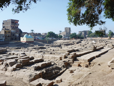
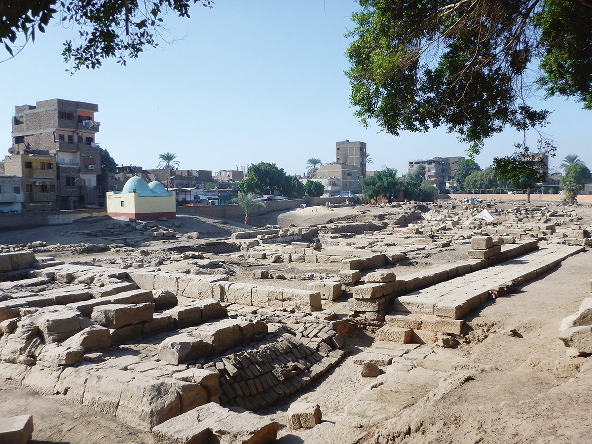
General view of the site of Armant.
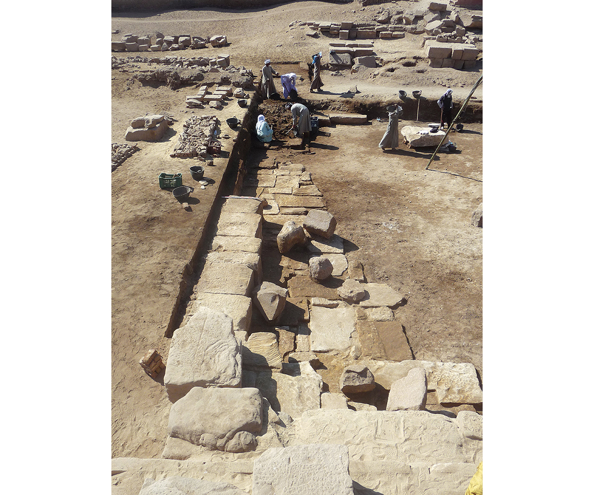
Façade of the “pronaos” during excavation.
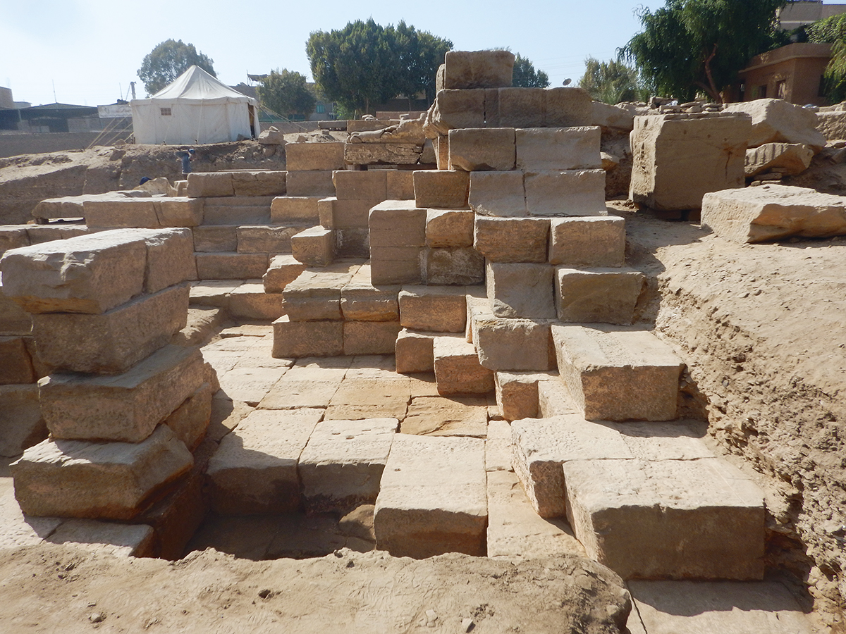
Foundation layers of the Ptolemaic naos, at the back of the temple.
Movement of blocks in the central area of the temple.
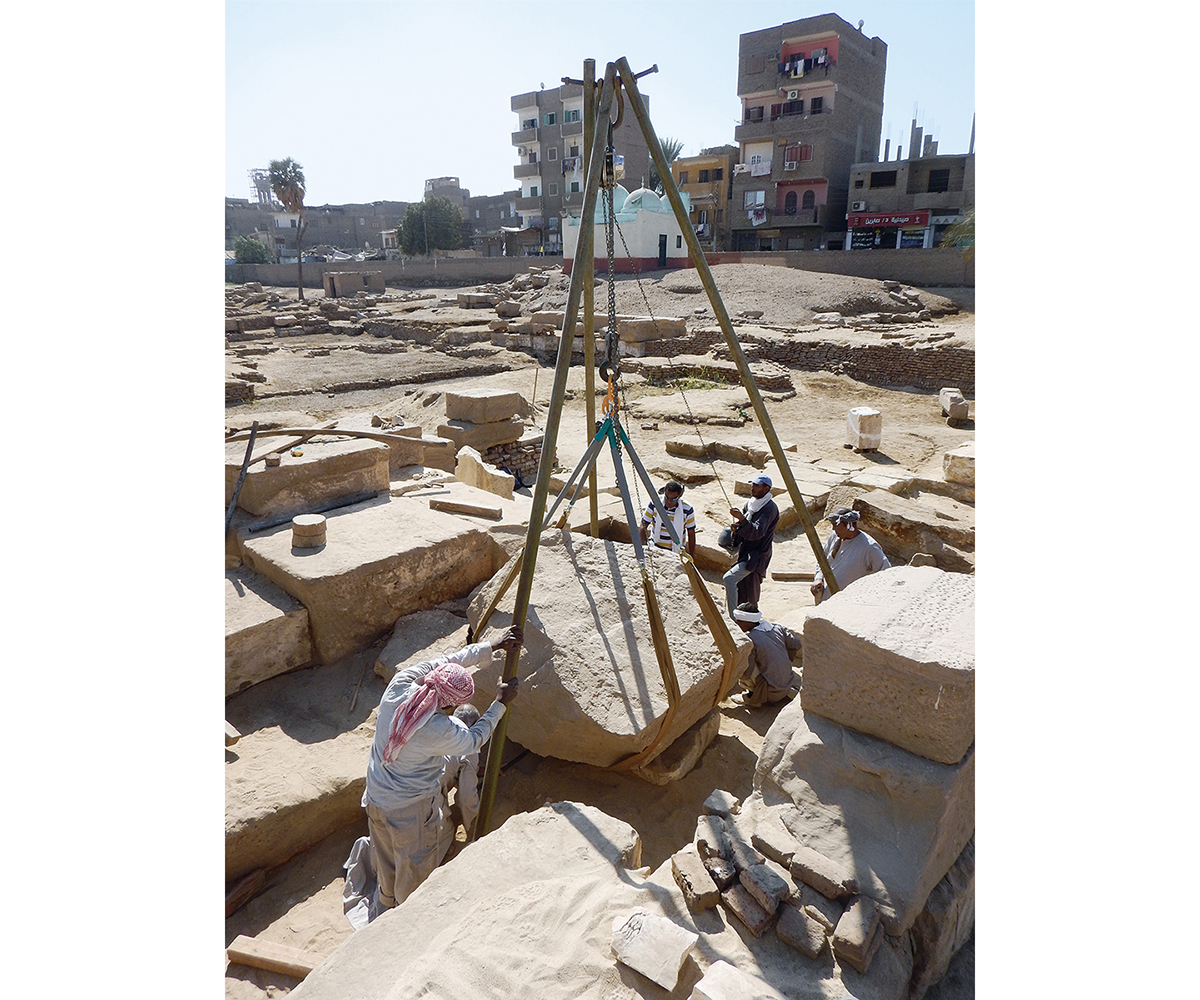
© J. Maucor.
Royal and private statues after restoration.
Les premières investigations archéologiques à Ermant ont été menées sous les auspices de l’Egypt Exploration Society par Robert Mond et Oliver Humphrys Myers dans les années 1930-1940, au Buchéum d’une part (catacombes des taureaux sacrés) et sur le site du temple majeur de Montou-Rê d’autre part. À l’arrière du pylône du Nouvel Empire, ils fouillèrent un village copte et mirent partiellement au jour une vaste plateforme de fondation du temple ptolémaïque, résultat de l’épierrement massif de l’édifice conduit dès le Ve s. Les travaux furent ponctuellement poursuivis par le Conseil suprême des antiquités (CSA) dans les années 1980 et 1990, faisant en particulier apparaître un ensemble de cryptes. Sous les auspices de l’Institut français d’archéologie orientale du Caire (Ifao), en 2002 et 2003, deux courtes campagnes menées par Christophe Thiers et Youri Volokhine permirent de copier et de publier les textes de ces cryptes datées de Ptolémée XII Néos Dionysos (80-51 av. J.-C.). Ce n’est qu’à partir de 2004-2005 que les travaux se sont développés pour tenter d’appréhender dans leur globalité les vestiges disséminés dans la ville et proposer une analyse architecturale, topographique et épigraphique des ruines du temple principal du dieu Montou. Parallèlement étaient initiés l’inventaire des blocs disséminés sur le site et un programme de restauration et de conservation des vestiges.
Principaux résultats
La principale originalité de la partie ptolémaïque (naos) du temple d’Ermant est qu’elle présente un niveau de circulation souterrain, dont les espaces (salles, cryptes, couloir mystérieux et caissons de fondation) et les murs principaux permettent d’appréhender l’agencement des salles du temple. Suite à la réalisation d’un plan topographique général, il s’est donc agi d’entreprendre l’analyse de la plateforme de fondation de l’édifice ptolémaïque et romain. Un long processus d’évacuation des débris a conduit à la réalisation d’un premier plan du temple par Pierre Zignani et à son analyse dans le cadre plus général de la construction des derniers grands temples de Haute Égypte. Le plan ainsi que les rapports de proportions sont ainsi étonnamment similaires à ceux du temple de Dendara.
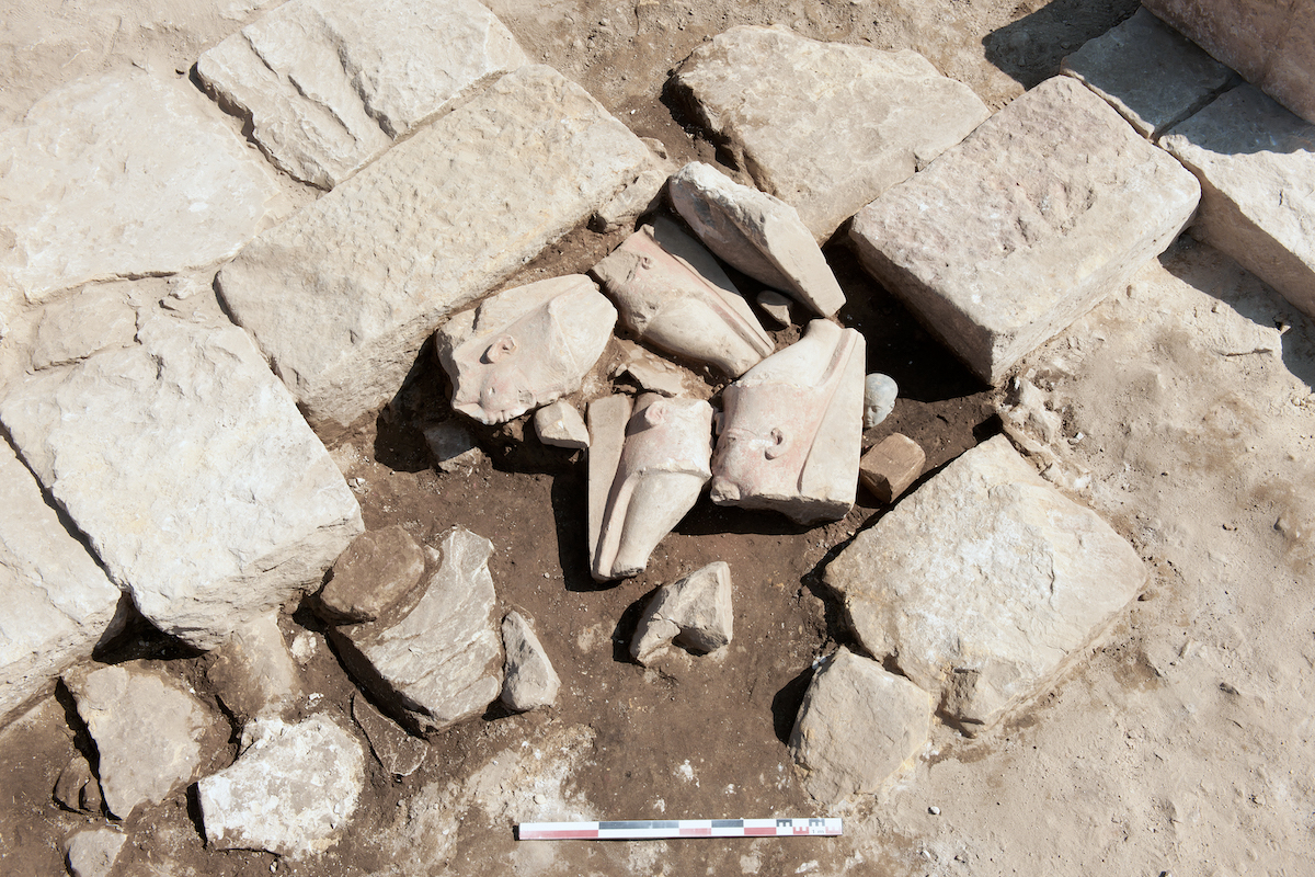
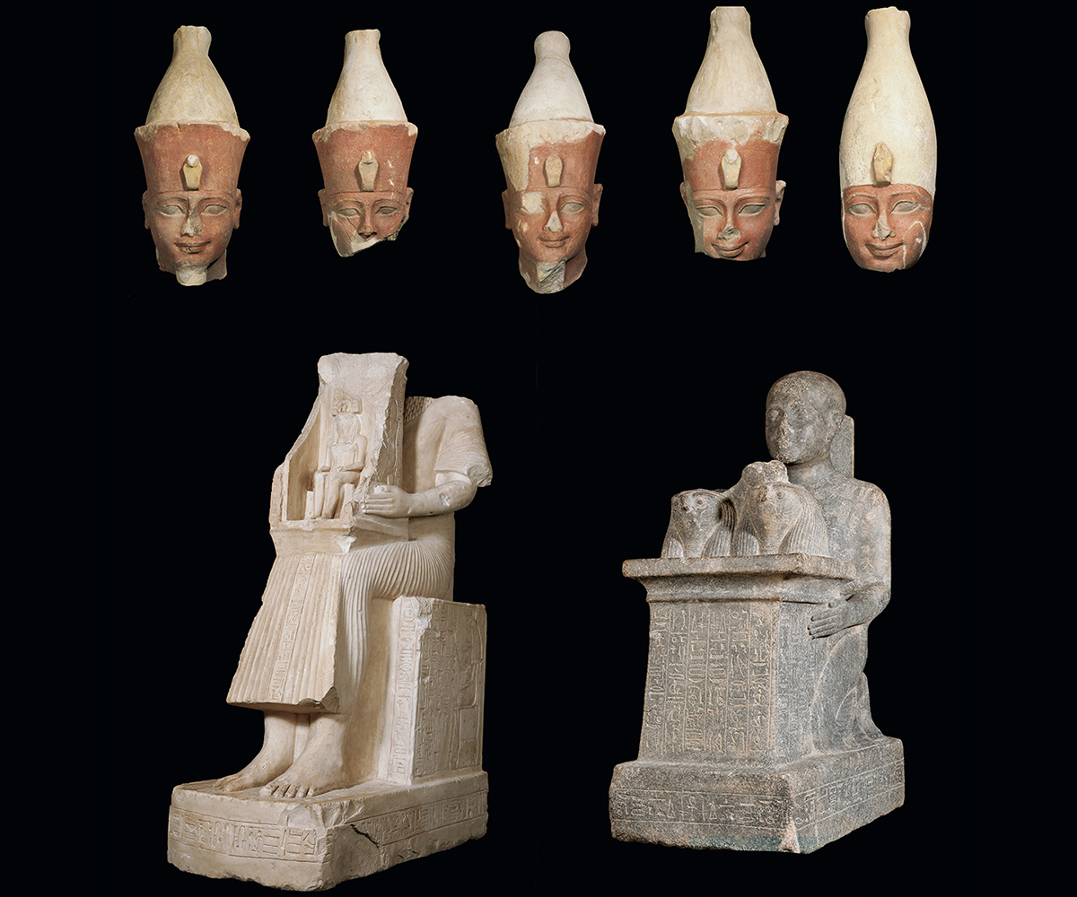
La fouille des niveaux de destruction et d’épierrement a également conduit à la découverte de nombreux blocs inscrits et éléments statuaires royaux et privés remployés dans les fondations. Ainsi, nombre de pierres appartenant aux temples du Moyen Empire (étude menée par Lilian Postel) ont été mises au jour ; elles datent principalement d’Amenemhat Ier et constituent le plus important ensemble lapidaire au nom de ce souverain. De nombreux blocs apportent un éclairage sur les développements architecturaux et théologiques du site à la fin de la XVIIe dynastie (stèle au nom de Kamosis) et au Nouvel Empire (étude par Sébastien Biston-Moulin) : monuments de Thoutmosis III et d’Hatchepsout (martelée), texte annalistique, piliers osiriaques de Thoutmosis III et de Séthi II, statuaire privée de la fin de l’époque amarnienne-début de l’époque ramesside, programme de restauration du pylône Nouvel Empire sous Ramsès Ier. En outre, plusieurs blocs aux noms d’empereurs romains (Auguste, Néron, Vespasien, Hadrien) ont été mis au jour.
Les niveaux archéologiques atteints au fond des fosses de fondations respectives du naos et du « pronaos » ont révélé la présence de structures en briques crues et de foyers, largement entamés lors de la mise en place des premières assises de fondation. Les ensembles céramiques datent cette occupation de l’Ancien Empire (IVe-VIe dynasties). En bordure du temple, des niveaux du Moyen Empire ont également été repérés.
À l’extérieur de l’emprise moderne du site, les travaux concernent la porte d’Antonin le Pieux (« Bab el-Maganîn ») et les nombreux blocs gisant à proximité, de même que l’étude archivistique du mammisi aux noms de Césarion et Cléopâtre VII détruit en 1860-1861.
Perspectives
L’étude d’un site sur la longue durée, de l’Ancien Empire à la période romano-byzantine, c’est-à-dire sur près de trois millénaires, constitue une formidable opportunité pour saisir les évolutions topographiques, architecturales et théologiques d’un temple égyptien majeur de la région thébaine. Les résultats extrêmement stimulants obtenus ces dernières années conduisent à envisager la poursuite du programme Ermant, dont les objectifs se déclinent ainsi :
– la poursuite des fouilles apportera une meilleure connaissance de l’histoire d’un temple majeur de Haute Égypte et du territoire qui l’a accueilli ; les analyses architecturales, épigraphiques et céramologiques produiront des données essentielles sur l’évolution du site ;
– les ensembles épigraphiques déjà réunis et ceux qui ne manqueront pas d’être révélés par la poursuite des fouilles assureront la production et l’édition de sources hiéroglyphiques inédites (à verser aux études sur l’histoire et les théologies thébaines, la prosopographie, etc.) ;
– le projet d’étude du site d’Ermant est volontairement inscrit dans une dimension géographique, au niveau local mais également au niveau régional, en lien avec les sites voisins de la région thébaine, en particulier Tôd, Karnak et Médamoud, trois autres sites majeurs consacrés au dieu Montou-Rê ;
– enfin, les recherches épigraphiques et archéologiques sont intimement associées à la préservation et à la mise en valeur du site ; le programme de restauration des blocs épars et des structures en place sera poursuivi, l’accent pouvant être porté sur des projets ponctuels d’anastylose d’ensembles lapidaires.
Christophe Thiers (CNRS, UMR 5140)
During the years 1930-1940, the first archaeological investigations at Armant were led by Robert Mond and Oliver Humphrys Myers under the auspices of the Egypt Exploration Society. They were conducted both at the Bucheum (the catacombs of sacred bulls) and at the site of the main temple of Montu-Ra. Behind the New Kingdom pylon, they excavated a Coptic village and partially exposed a vast foundation platform of the Ptolemaic temple, the remains which followed the massive removal of the structure’s stonework from the 5th century. Work there was conducted intermittently by the Supreme Council of Antiquities (SCA) in the 1980s and 1990s, exposing in particular a set of crypts. In 2003 and 2004, under the auspices of the IFAO, the two short seasons led by Christophe Thiers and Youri Volokhine enabled the texts of these crypts, which date to Ptolemy XII Neos Dionysos (80-51 BC), to be copied and published. It was only after 2004-2005 that work was undertaken to attempt to understand the scattered remains in the city in their entirety and to propose an architectural, topographic and epigraphic analysis of the ruins of the main temple of the god Montu. At the same time an inventory of blocks scattered over the site and a programme of restoration and conservation was initiated.
Principal results
The most striking feature of the Ptolemaic part of the Armant temple (the naos) is that it reveals the foundational level where subterranean activities took place. These areas (rooms, crypts, a corridor around the holy of the holies and the foundations of now vanished temple rooms) and main walls enable us to gain an idea of the temple’s layout. After producing a general topographic plan, an analysis of the foundation platform of the Ptolemaic and Roman structure was then carried out. A long process of removing debris enabled Pierre Zignani to produce the first plan of the temple and an analysis in the framework of the general construction layout of the last great temples of Upper Egypt. The plan, as well as temple dimensions, are astonishing similar to those at the temple of Dendara.
Excavation of the levels of destruction and removal of stone led also to the discovery of numerous inscribed blocks and fragments of royal and private statuary reused in the foundations. Numerous stones belonging to Middle Kingdom temples (being studied by Lilian Postel) were brought to light. Dating principally to Amenemhat I, they comprise the most important inscribed assemblage with the name of this ruler. Many blocks cast light on the architectural and theological developments at the site at the end of the 17th Dynasty (e.g. a stela with the name Kamose) and during the New Kingdom (being studied by Sébastien Biston-Moulin). These include monuments of Tuthmosis III and Hatshepsut (chiselled out), an Annales text, Osirian pillars of Tuthmosis III and Seti II, private statuary from the end of the Amarna period to the beginning of the Ramesside period, and a restoration inscription of the New Kingdom pylon under Ramesses I. Blocks with the names of Roman emperors (Augustus, Nero, Vespasian and Hadrian) have also been uncovered.
Archaeological levels reached at the base of foundation pits relating to the naos and to the “pronaos” revealed the presence of mud-brick structures and dwellings which were mostly damaged during the digging of foundations in the Ptolemaic and Roman periods. The ceramic assemblages date this occupation to the Old Kingdom (4th-6th Dynasties). At the edge of the temple, Middle Kingdom layers have similarly been located.
Outside the modern extent of the site, work is being conducted at the gateway of Anoninus Pius (“Bab el-Maganin”) and the numerous blocks in its vicinity, and an archival analysis of the mammisi (destroyed in 1861-1862) with the names of Caesarion and Cleopatra VII is being carried out.
Perspectives
The study of a site which survived so long, from the Old Kingdom to the Roman-Byzantine period (nearly three millennia) constitutes an important opportunity for comprehending the topographic, architectural and theological evolution of a major Egyptian temple in the Theban region. The very thought-provoking results reached during the last few years have encouraged us to continue the Armant programme, whose objectives are as follows:
– A better understanding of the history of a major temple in Upper Egypt and its surrounding area will be achieved through excavation. Architectural, epigraphic and ceramic analyses will produce essential data concerning the evolution of the site;
– The epigraphic items already recovered, and those that will undoubtedly be revealed during further excavations, will ensure the production and publication of new hieroglyphic texts which will benefit studies on Theban history and theologies, prosopography etc.;
– The project relating to the site of Armant is undoubtedly set within a geographical context, at a local but also regional level, as it is linked with neighbouring sites in the Theban region, in particular with Tod, Karnak and Medamud, three other major sites dedicated to the god Montu-Ra;
– Finally, the epigraphic and archaeological research is closely connected to the preservation and enhancement of the site. The programme of restoration of scattered blocks and structures in situ will continue, focusing on specific projects relating to the reconstruction of sets of blocks.
Christophe Thiers (CNRS, UMR 5140)
أُجريت الحفائِر الأثريَّة الأولى في أرْمَنْت تحت رعاية جمعية استكشاف مصر بمعرفة روبرت موند وأوليڨر همفريز مايرز في أعوام ١٩٣٠-١٩٤٠، أولًا في بوخيوم (مدافن الثيران المُقدَّسة)، ثم في موقع المعبد الرئيس لمونتو-رَعْ. وفي الجزء الخلفيّ من الصَّرح الذي يعود للدولة الحديثة، قام الأثريَّان بالتنقيب في قرية قِبْطيَّة وكشفا جزئيًّا عن أرضيَّةٍ واسعةٍ لأساس المعبد البطلميّ؛ كنتيجة لعمليَّة إزالة الأحجار الهائلة للبناء، والتي تمَّت بِدءًا من القرن الخامس. تابَع المجلس الأعلى للآثار أعمال البحث خلال ثمانينيَّات وتسعينيَّات القرن الماضي؛ مما كشف بصفةٍ خاصَّةٍ عن مجموعة من السراديب. وفي عامَيّْ ٢٠٠٢ و٢٠٠٣، تحت رعاية المعهد الفرنسيّ للآثار الشرقيَّة، ومن خلال بعثتين قصيرتين بقيادة كريستوف تيير ويوري ﭬولوكين، تم نَسْخ ونَشْر نصوص هذه السراديب المُؤرَّخة من عصر بطليموس الثاني عشر، نيوس ديونيسوس (٨٠-٥١ ق. م.). غير أنه بِدءًا من ٢٠٠٤-٢٠٠٥، تطوَّرت الأعمالُ في محاولةٍ لمعاينةِ وفهمِ مُجمَل الآثارِ المنتشرةِ في المدينة، واقتراح تحليلٍ معمارىّ وطوبوغرافىّ وإبيجرافي لبقايا المعبد الرئيس للإله مونتو. وبالتزامن مع هذه الأعمال، تم البِدْءُ في جردِ الكُتَلِ المتناثرةِ المنتشرةِ في الموقعِ مع برنامجِ ترميمٍ وحفظٍ للبقايا الأثريَّة.
النتائج الرئيسة
السمة الفريدة الأساسيَّة للجزء البطلميّ («ناووس») من معبد أرمنت هو أنه يقدم مستوًى من المرور أسفل الأرض؛ حيث تسمح مساحاته (القاعات، السراديب، المَمَرّ السِّرِّيّ وتجاويف الأساس) والجدران الرئيسة بمعاينة وفهم تنظيم قاعات المعبد. فبعد رسم خريطة طُبُوغرافيَّة عامًّة، كان لزامًا الاضطلاع بتحليل الأرضيَّة الواسعة الخاصَّة بأساس المبنى البطلميّ والرومانيّ. وقد قادت عملية طويلة من إزالة الأنقاض إلى وضعِ خريطة أوليَّة للمعبد بمعرفة پيير زينياني، وتحليل المعبد في السياق العام لبناء آخرِ المعابدِ الكبرى في مصر السفلى. وهكذا تشابهت الخريطة ونِسَب الأبعاد بشكلٍ مذهلٍ مع خريطة ونسبِ أبعادِ معبدِ دَنْدَرَة.
كما أسفر التنقيب في مستويات الهدم وعملية إزالة الأحجار عن اكتشاف العديد من الكُتَل المنقوشة، وعناصر تماثيل مَلَكيَّة وخاصة أُعيد استخدامها في الأساسات. وهكذا، تم اكتشافُ عددٍ من الأحجار التي تخصُّ معابد الدولة الوسطى (ليليان پوستيل)؛ يرجع تاريخها أساسًا إلى أمنمحات الأول وتُشكِّل أهمَّ مجموعةٍ حجريَّةٍ باسم هذا الملك. تُسلِّط الكثيرُ من الكُتَل الضوءَ على التطوُّرات المعماريَّة واللاهوتيَّة للموقع في نهاية الأسرة السابعة عشرة (لوحة باسم كامُس) وكذلك في عصر الدولة الحديثة (سباستيان بيستون-مولان)، ألا وهي آثار لتحتمس الثالث ولحتشبسوت، وأعمدة أوزيريَّة لتحتمس الثالث ولـ «سيتى الثاني»، وتماثيل خاصَّة من نهاية فترة العَمَارِنَة-بداية الرَّعَامِسَة، وبرنامج ترميم الصَّرح الذي ينتمي للدولة الحديثة تحت حكم رمسيس الأول. كما تم اكتشاف الكثير من الكتل التي تحملُ أسماءَ الأباطرةِ الرومان الذين لم يكن قد أُشير إليهم حتى الآن في الموقع (أغسطس، نيرون، ﭬيسپاسيان، هادريان).
أتاح لنا الإظهار الجُزْئيّ لنطاقِ «مُقدِّمة المعبد» والناووس، ملاحظةَ المستوياتِ الأثريَّة التي تمَّ بلوغُها أثناء نَقْب حُفَر الأساس لكُلٍّ من الكيانيْن المعماريَّيْن. كشفت هذه المستوياتُ عن وجودِ هياكلَ من الطوبِ اللَّبِن ومساكن، تمَّ البِدْءُ فيها إلى حَدٍّ كبير مع وضع قواعد الأساس الأولى. وتُؤرِّخ مجموعاتُ الخَزَفْ هذا الإشغال لعصر الدولة القديمة (الأسرتان الخامسة والسادسة).
أما خارج النطاق الحديث للموقع، تركَّزت الأعمالُ أيضًا على بوَّابة أنطونيوس پيوس («باب المجانين») وعلى الكثير من الكتل المتناثرة المُلقَاة على مقربة منها، بالإضافة إلى الدراسة الوثائقيَّة الخاصة ببيت الولادة الذي يحمل اسمَيّْ قيصرون وكليوپاترا السابعة والذي تهدَّم في ١٨٦٠-١٨٦1.
الآفاق
دراسةُ موقعٍ ما على المدى الطويل، من الدولة القديمة إلى الفترة الرومانيَّة-البيزنطيَّة، أى ما يقرب من ثلاثة آلاف سنة، هي فرصة عظيمة لفهم التطورات الطبوغرافيَّة والمعماريَّة واللاهوتيَّة لمعبدٍ مصريٍّ رئيسٍ في منطقة طِيبَة. وقد دفعتنا النتائج المُحفِّزة للغاية التي توصلنا إليها في السنوات الأخيرة إلى النظر في مواصلة برنامج أرمنت، والذي يمكن إيجاز أهدافه فيما يلي:
– استمرارُ الحفائِر، والتي سوف تتيحُ معرفةً أفضلَ لتاريخِ معبدٍ رئيسٍ في مصر السفلى والإقليم الذي قام باستقباله؛ كما ستقدمُ التحليلاتُ المعماريَّة والإبيجرافيَّة والخَزَفيَّة (رومان ديڤيد وسيلڤي مارشان) بياناتٍ أساسيَّةً عن تطور الموقع؛
– المجموعات الإبيجرافيَّة التي تمَّ تجميعُها بالفعل وتلك التي لن نتأخر في الكشف عنها من خلال استمرار الحفائِر، سوف تضمن إنتاجَ ونشرَ المصادرِ الهيروغليفيَّةِ غير المعروفة (لدفع الدراسات الخاصَّة بالتاريخ واللاهوت الطِّيبِيّ، إلخ)؛
– مشروعُ دراسةِ موقع أرمنت مُدرَجٌ في نطاقٍ جغرافيّ، ليس فقط على المستوى المحليّ ولكن أيضًا على المستوى الإقليميّ لاتصاله بالمواقع المجاورة لمنطقة طِيبَة؛ وعلى الأخصِّ طود والكرنك ومَدَامُود، وهي ثلاثةُ مواقع رئيسة أخرى مُخصَّصة للإله مونتو رع؛
– أخيرًا، ترتبطُ الأبحاثُ الإبيجرافيَّة والأثريَّة ارتباطًا وثيقًا بالحفاظ على الموقع وتطويره؛ سوف يستمر برنامج ترميم الكتل المتناثرة والهياكل القائمة، مع التركيز على مشروعات دقيقة لإعادة تركيب مجموعات صقل الأحجار.
كريستوف تيير (المركز الوطنيّ للبحث العلمي، UMR 5140)
Bibliographie
- C. Thiers, Y. Volokhine, Ermant. I. Les cryptes du temple ptolémaïque. Étude épigraphique, MIFAO 124, Le Caire, 2005.
- Y. Volokhine, P. Sanchez, P. Schubert, « Une dédicace grecque de l’époque impériale tardive trouvée à Hermonthis (Ermant, Haute Égypte) », ZPE 174, 2010, p. 127-132.
- C. Thiers, « Armant: recent discoveries at the temple of Montu-Re », EgArch 44, 2014, p. 32-35.
- P. Zignani, « L’architecture du temple de Montou à Ermant. Essai d’approche typologique et proportion du plan », BIFAO 114, 2014, p. 589-606, en ligne, https://www.ifao.egnet.net/bifao/114/23/.
- S. Lippert, « Varia demotica d’Hermonthis », BIFAO 115, 2015, p. 231-264, en ligne, https://www.ifao.egnet.net/bifao/115/10/.
- L. Postel, « Nouvelles données sur le temple d’Amenemhat Ier à Ermant », BSFE 191-192, 2015, p. 24-38.
- Page web Ermant archivée (2012)